skip to main |
skip to sidebar
 Although Council Grove in western Oklahoma County has a venerable history and tradition much older than Oklahoma City, it's not often mentioned as part of our early-day legacy. The above image from Charles Robert Goins and Danney Gobles' Historical Atlas of Oklahoma, 4th Ed (University of Oklahoma Press 2006) shows the region at page 125.
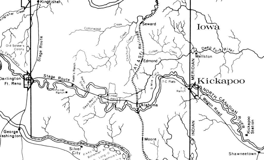
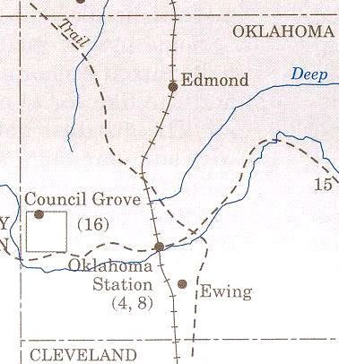
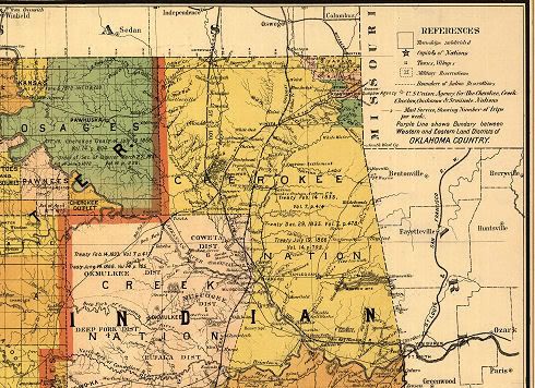
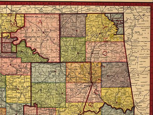
The map below is a crop from a map contained in The Oklahoma Land Rush of 1889 by Stan Hoag (Oklahoma Historical Society 1984). The map shows the complete area embraced in the April 22, 1889, Land Run, but this crop focuses on the area discussed in this article. Notice the area identified as "Timber Res" -- that is Council Grove. The map shows that a stage route ran through it from El Reno. If you'd like to see a 2827 x 3444 pixel version of the entire map, click here.
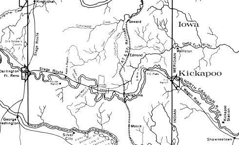
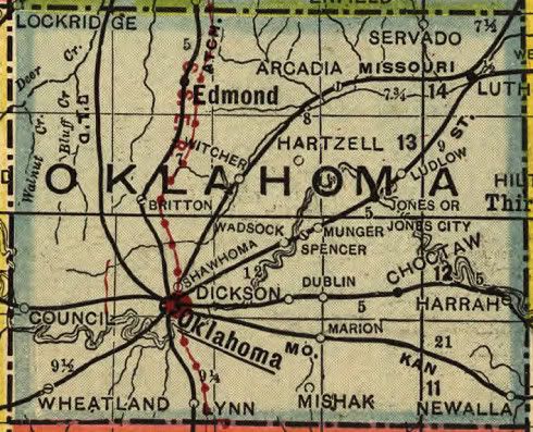
A pair of post-land run maps show the Council Grove area:
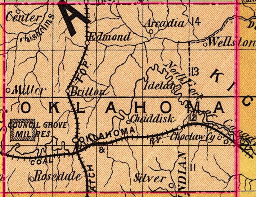
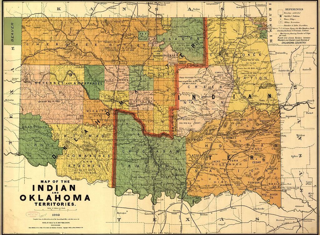
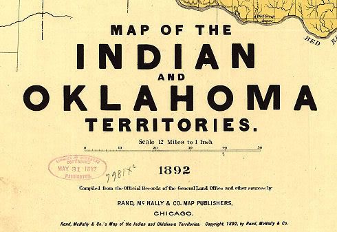
1892 Rand McNally Oklahoma Map
(see this article here for much more about that map)

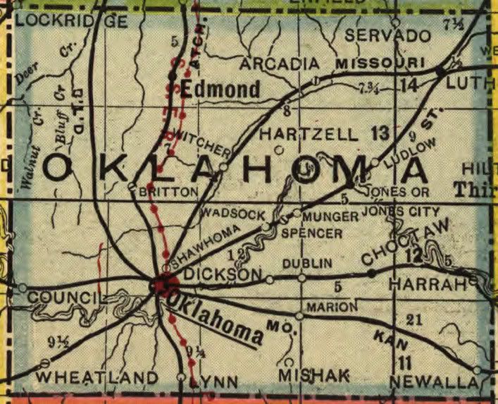
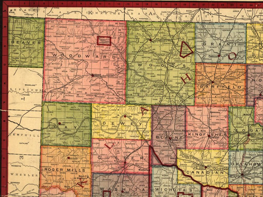
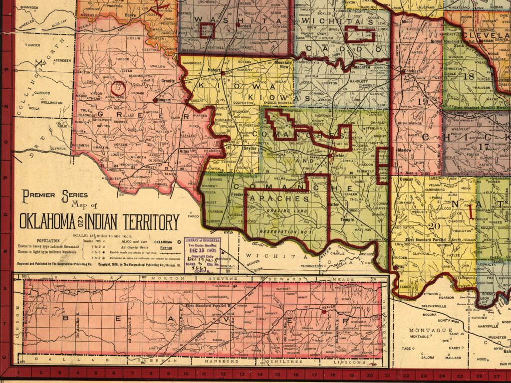
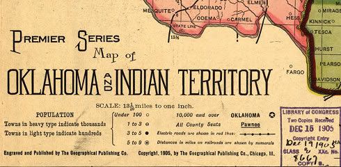
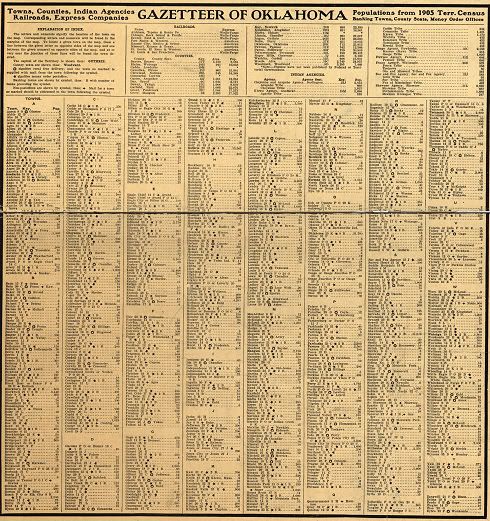
1905 Geographical Publishing Company Map
(see this article here for much more about that map)
(The gazetter with this map shows a population of 18)
Those living in Oklahoma City are familiar with "Council Road" which runs north-south along the east side of Lake Overholser one mile east of the western Oklahoma County boundary. The road gets its name from the historic "Council Grove" area which no longer exists as such even though schools and street names bear all or some parts of the name. But, what was "Council Grove?"
The Bethany, Oklahoma, website contains the most information and says this:
Council Grove was an important part of the “Unassigned Lands.” Although it was in the Creek Nation, it was a gathering place for many of the Plains Indians. Its good spring water and its large grove of cottonwood, elm and oak trees made it an attractive spot for Indian Councils. It was here that the Confederate Indians decided to hold a council with the Plains Indians when it became obvious that the tide had turned against them in the Civil War. Because Union armies were too near this area, they moved to Camp Napoleon in what is now Verden, Oklahoma.
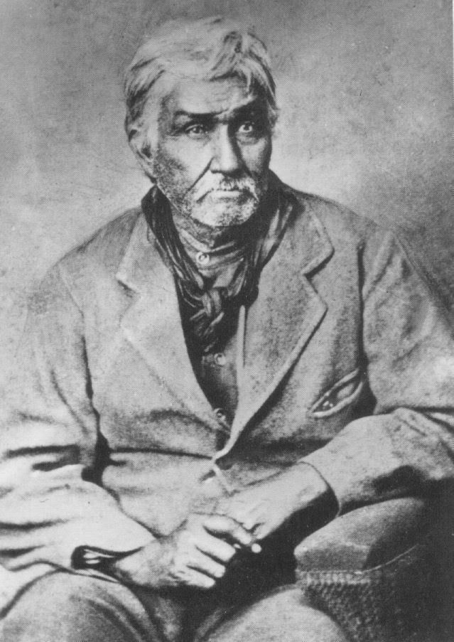
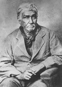 Just before the Civil War (1858), Jesse Chisholm opened a trading post at Council Grove. This great trader is remembered for the famous cattle trail named for him although he was never a part of the cattle business. He was also a nephew of Tiana Rogers, the Cherokee wife of Sam Houston. (One writer says: “Chisholm’s part in the history of Oklahoma . . . is fully as important and no less romantically picturesque than that of Daniel Boone in Kentucky.”) Council Grove had famous visitors in 1859. One of these, Colonel B.L.E. Bonneville who as a youth had been a close friend of LaFayette, but had been exiled to America because he found himself on the losing side when Napoleon came into power. He graduated from West Point in the same year that Napoleon started his sojourn at St. Helena. With Bonneville were Congressman J.S. Phelps of Missouri, and Superintendent of Indian Affairs Collins. These leaders came with 180 troops to have a conference with the Comanches in which they hoped to establish more friendly relations between these Plains Indians and nearby white settlers. But the expedition contained just 180 too many soldiers; so the Comanches, mindful of the attack upon their camp while on a peaceful mission in 1858, broke their camp at Council Grove and fled northward in great confusion. Just before the Civil War (1858), Jesse Chisholm opened a trading post at Council Grove. This great trader is remembered for the famous cattle trail named for him although he was never a part of the cattle business. He was also a nephew of Tiana Rogers, the Cherokee wife of Sam Houston. (One writer says: “Chisholm’s part in the history of Oklahoma . . . is fully as important and no less romantically picturesque than that of Daniel Boone in Kentucky.”) Council Grove had famous visitors in 1859. One of these, Colonel B.L.E. Bonneville who as a youth had been a close friend of LaFayette, but had been exiled to America because he found himself on the losing side when Napoleon came into power. He graduated from West Point in the same year that Napoleon started his sojourn at St. Helena. With Bonneville were Congressman J.S. Phelps of Missouri, and Superintendent of Indian Affairs Collins. These leaders came with 180 troops to have a conference with the Comanches in which they hoped to establish more friendly relations between these Plains Indians and nearby white settlers. But the expedition contained just 180 too many soldiers; so the Comanches, mindful of the attack upon their camp while on a peaceful mission in 1858, broke their camp at Council Grove and fled northward in great confusion.
The first attempt at a permanent settlement was a result of ignorance of the geography of the region. Thinking that he was in Chickasaw country, Montford Johnson started ranching operations that included “ground covered with acorns, a paradise for hogs in the fall of the year.” His discovery of error seems to have coincided with a proclamation by President Hayes that warned homesteaders to keep out of the “Unassigned Lands.” He, therefore, had to abandon his Council Grove Ranch. Johnson continued his ranching activities south of the Canadian River that was safely in Chickasaw territory and is credited with starting the first bank in Minco.
In 1889, the United States Government set aside the equivalent of nine sections as a source of timber needed for Fort Reno. The area included all of Bethany south of N.W. 42nd Street and extended southward to a half mile south of N.W. 10th Street and from Council Road eastward for about three miles. It was soon deemed practical to move a sawmill from Darlington (near Fort Reno) to near the present N.W. 10th Street Bridge.
When the “Unassigned Lands” were opened in 1889, this part of Council Grove was exempted from settlement. People in the surrounding area were permitted to take fallen timber for fuel. Those who knew how to avoid the spirit, but live up to the letter of the law quickly abused this permission. One day they would cut down timber and the next day they returned to take this as “fallen timber.”
The coming of what is now the Rock Island Railroad relieved the government’s need for the timber reserve so this area was opened for settlement. Homesteaders who were a part of the “run” of 1889 purchased much of the land. The first sale was on December 1, 1896. Among the purchasers was I.F. Melrose, who obtained forty acres at $2.00 per acre. This title had the signature of President Grover Cleveland. The next sale occurred in 1901, but this time, the price was $17.50 per acre. Mr. Melrose purchased another forty acres but he decided to stop with this amount because that was too much to pay for land even if it did have the signature of President William McKinley on the papers. From this Oklahoma Historical Society Chronicles of Oklahoma article, we read:
William Darlington who was a cousin of Edwin F. Williams, and who was an experienced engineer and mechanic, was placed in charge of the removal and reinstallation of the engine, boiler and saw-mill and he directed its operation thereafter. The plant was set up just north of "Dead Man's Crossing," now better known as the West Tenth Street Bridge, about half a mile below the Oklahoma City Water-works dam, in Council Grove Township, west of Oklahoma City. There, most of the best post-oak and whiteoak timber in the Council Grove area was sawed up into the heavier grades of lumber to be hauled to Fort Reno. Council Grove was later set aside as a wood reserve to supply Fort Reno with fuel and fence posts and, as such, it was reserved from settlement when Oklahoma was opened to homesteaders, in 1889. Its lands were not thrown open for sale until in December, 1899. Judging by the other references already identified in this article, the OHS's "December 1899" date for the property becoming available "for sale" appears to be inaccurate. Also, see Jesse Chisholm: Ambassador Of The Plains by Stan Hoig (University of Oklahoma Press 2005) at Amazon. Chisholm died of food poisoning in March 1868 at Geary and he is buried near Left Hand Spring, northeast of Geary.
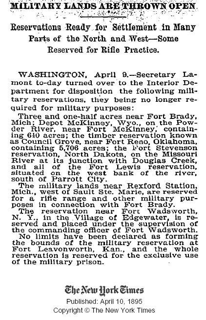
As noted above, the area became open to settlement in 1889. This authorization apparently occurred in 1885, as evidenced by this brief article in the New York Times ...
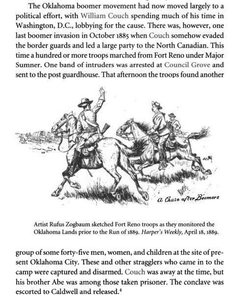
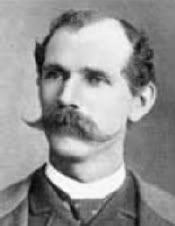 Before the April 22, 1889, Land Run and before he became Oklahoma City's first mayor (provisionally), William L. Couch led a group of "Boomers" into Oklahoma County, establishing a presence at Council Grove before being escorted back to Kansas, probably by Ft. Reno's black cavalry group known as the Buffalo Soldiers, as said by Larry Johnson in this article at the Oklahoma City Metropolitan Library website (you may have to press your refresh key - F5 - for the link to load). There, he said, Before the April 22, 1889, Land Run and before he became Oklahoma City's first mayor (provisionally), William L. Couch led a group of "Boomers" into Oklahoma County, establishing a presence at Council Grove before being escorted back to Kansas, probably by Ft. Reno's black cavalry group known as the Buffalo Soldiers, as said by Larry Johnson in this article at the Oklahoma City Metropolitan Library website (you may have to press your refresh key - F5 - for the link to load). There, he said,
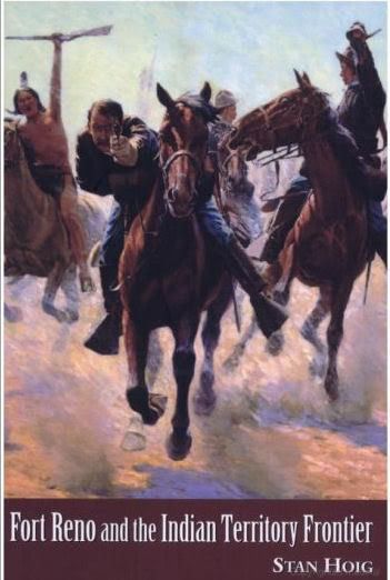
In 1880 settlers from Kansas, known as Boomers because they loudly pushed for opening, attempted to settle in Oklahoma land. Led by David L. Payne and William Couch, the Boomers arrived at land near what is now west of Trosper Park and tried to begin farming, but they were arrested by soldiers from Fort Reno and sent back to Kansas. They made many more attempts to settle: once near what is now Stiles Park; once they laid out a townsite called Ewing (Ewing Cemetery is still on Northeast 63rd Street); and they even tried to settle near Council Grove in 1885 and killed some of Montford Johnson´s hogs and cows! Each time they were run out of "Oklahoma City" by the 9th and 10th Cavalry (Buffalo Soldiers) from Fort Reno. Another illustration is given in Fort Reno And the Indian Territory Frontier by Stan Hoig (University of Arkansas Press 2005), available at Amazon. The book cover and an excerpt are shown below.
See my Cops & Robbers Boomers/Sooners article for a little more on the topic.
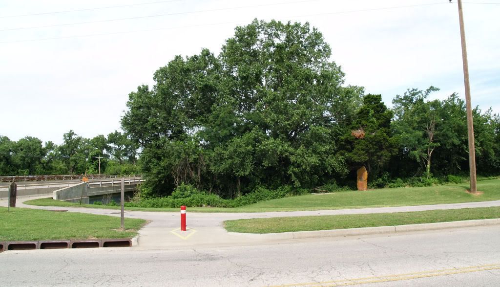
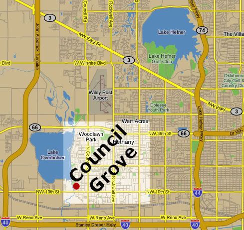
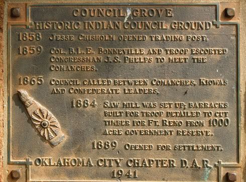
In this Chronicles of Oklahoma article, I learned that the Council Road Chapter of the Daughters of the American Revolution established a historical marker for Council Grove in 1941, near Northwest 10th at the North Canadian River. Not being aware of that until yesterday, Sunday morning, June 29, 2008, I decided to see if it was still there. It was.
Approximate location and area of Council Grove
The red spot by NW 10th is the marker location
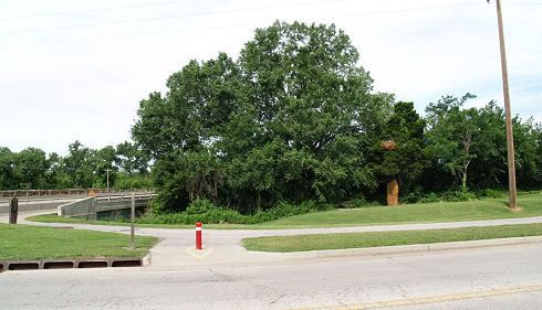
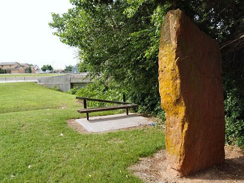
Here are a few photos taken that morning.
Looking West at NW 10th From East of Council Road
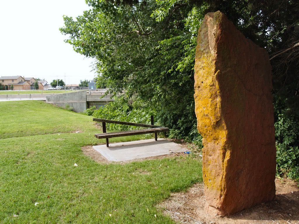
A closer look at the marker
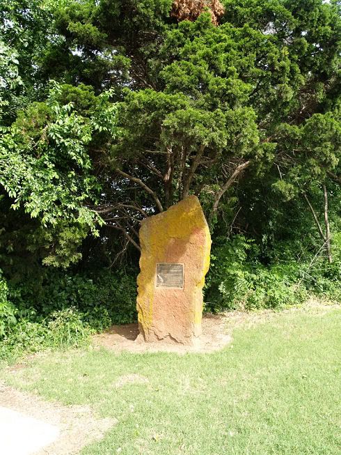
The Commemorative Plaque
The Site Needs Maintenance
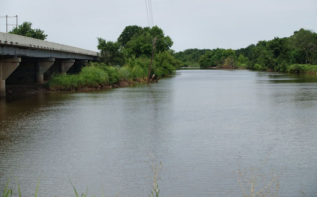
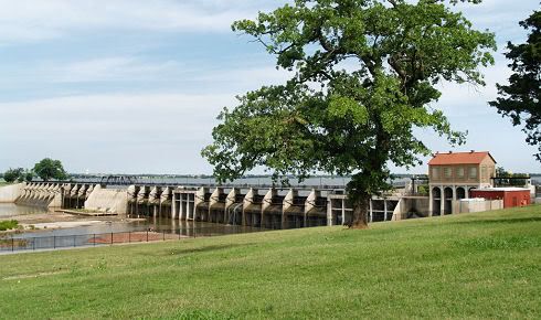
Council Grove Included Lake Overholser's Dam Area at NW 16th
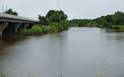
The area extended north to about this location,
looking west at the North Canadian, just north of the westbound bridge
For further reading, see Ray Asplin's "A History of Council Grove," Chronicles of Oklahoma, XLV (Winter 1968), 433-450, apparently not available on-line.
Go To Top
... Click here to read the full article and any comments ...
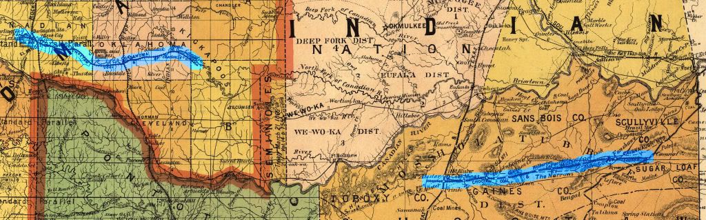
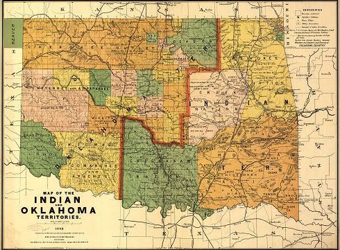
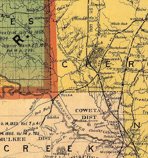
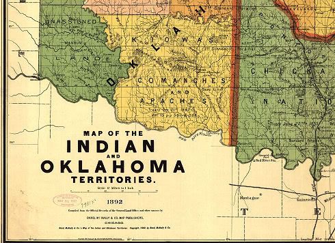
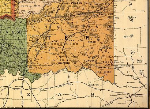
 In addition to the 1905 Oklahoma Map by Geographical Publishing Company of Chicago, another very high resolution map located in the Library of Congress map files is the 1892 Oklahoma and Indian Territories map made by Rand, McNally & Company, also of Chicago. This map has no "gazetter" or other index of populations and/or towns, at least, not in its LOC version. However, it does contain some information that the 1905 map does not -- occasional "road" trails, Indian treaty information, and it also presents a clearer demarcation between Oklahoma and Indian Territories.
Quick Links In This Article:
State Map Oklahoma County Vicinity Tulsa Vicinity
Quadrants: Northwest Southwest Southeast Northeast
A Preliminary Word of Caution: A spot-check of the Oklahoma County section of the map gives cause to think that Rand McNally did not take as much care with this map as Geographical Publishing Company did with its 1905 map -- at least a pair of towns shown to be in Oklahoma County are not -- Wellston, located in Lincoln County, and Rosedale, located in McClain County -- barring the unlikely event that those towns secretly pulled up stakes and moved from Oklahoma County after the 1892 map was prepared and about which possible exodus I could find no basis in fact.
So, while this map should apparently be viewed with a critical eye, it nonetheless presents an interesting comparison between the territories during the 13 year time-span between 1892 and 1905. As with the 1905 map article, high resolution images are available here for download for them that wants. You can also download the map for yourself at the Library of Congress website. If you do, the LOC file format is a "MrSid" file and you will need to download and install the free MrSid viewer from the LOC website, here, as I did. It's a small and efficient program that allows conversion to a different file format, as I've done with the images presented in this article. The downloaded file is very large -- 9774 x 7200 pixels!
The Full State Map. One of the most useful items in this map is its presentation of railroads and comparing that with the 1905 file. Keeping in mind that this map was prepared only three years after the 1889 Land Run, that change is astonishing and remarkable. If Rand McNally did its job reasonably well, it is also apparent that the number of towns increased dramatically between the production of this map and the 1905 rendition.
Click on the image for a 1024 px wide view, or
Click here for a 3000 x 2210 px view, or
Click here for a 4000 x 2947 px view, or
Click here for a 8624 x 6353 px view
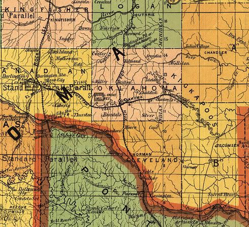
Oklahoma County Vicinity. Below, look closely and see the "Stage Road" running south of El Reno. Remember, in 1892, cars didn't exist. Also note that Chickasha, which would come to be located in Indian Territory directly south of El Reno, apparently did not then exist.
At the time of the 1889 Land Run, Oklahoma (City) had only one railroad passing through it, the north/south Atchison, Topeka & Santa Fe. By 1892, it had one other, a small piece of the Choctaw Coal & Railway Company east/west line, running from slightly west of El Reno to slightly east of Choctaw in what would become Pottawatomie County.
Click the image for a larger view, or
Click here for a 2068 x 1896 px view
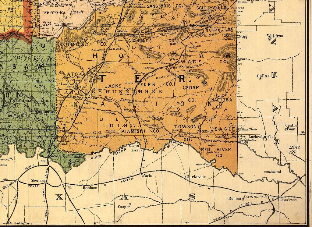
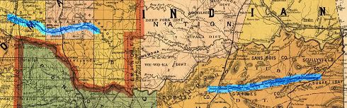
While the Choctaw Coal & Railway Company railroad line terminated east of Choctaw in what would become Pottawatomie County, if you look at the state map or the southeast quadrant, below, another segment of the same railroad is visible running from near the eastern border of Oklahoma through just west of McAlester, shown in small form below:
Click the image for a larger view
In 1902, this railroad became part of the fondly remembered "Rock Island" line, the Chicago, Rock Island and Pacific, and ran from Little Rock to Amarillo and points west. About this railroad, the OHS's Encyclopedia says this:
In 1885, after a field survey disguised as a turkey hunt, Edward D. Chadrick, a financier from Minneapolis, persuaded another titan of the railroad industry, the Lehigh Valley Railroad, to build a line that would tap the coal fields around Wilburton. The result was the incorporation of the Choctaw Coal and Railway Company in 1887 and the construction of a sixty-seven-mile line between Wister and South McAlester that was completed in 1890. This road permitted development of the coalfields at Wilburton, Alderson, and Hartshorne. Reorganized in 1894 as the Choctaw, Oklahoma, and Gulf Railroad Company, the line remained the territory's largest producer until acquired by the Chicago, Rock Island, and Pacific Railroad in 1902. Its mining subsidiary, the Rock Island Coal and Mining Company, continued to be one of the most powerful entities in Oklahoma's coal industry until the Great Depression. Also, see this website and this one which states,
Choctaw, Oklahoma and Gulf Railroad Company - Incorporated by act of Congress, provided "that the purchasers of the rights of way, railroads, mines, coal lease-holds, estates, and other property, and the franchises of the Choctaw Coal and Railway Company at any sale made under or by virtue of any process or decree of any court having jurisdiction thereof, shall be, and are hereby, constituted a corporation and shall be vested with all the right, title, interest, property, property, possession, claim and demand in law and equity, of, in, and to such rights of way, railroads, mines, coal leasehold estates, and property of the said Choctaw Coal and Railway Company, and with all the rights, powers, immunities, privileges, and franchises which have been heretofore granted to or conferred upon said Company by any Act or Acts of Congress, or which it possesses by virtue of its charter under the laws of Minnesota."
In 1894, The Choctaw, Oklahoma and Gulf Railroad took over the Choctaw Coal and Railway Company and immediately launched a large scale expansion program. The gap between McAlester and Oklahoma City was closed in October, 1895. The El Reno to Weatherford extension was completed in 1898. Oklahoma County and Then Some. As this is initially written, I've not "spot checked" any part of this map other than Oklahoma County for accuracy. Unfortunately, that spot-check shows at least two towns being located in Oklahoma County which were actually located elsewhere -- Rosedale was and is located in McClain County and Wellston was and is located in Lincoln County. Whether the results of this one-county spot check would be similar in other parts of the map, I can't say since I've made no attempt to do that elsewhere -- but I'd be surprised if similar errors aren't present in other parts of the map. So, as said at the outset of this article, look at this map "critically" and don't assume that what it presents is necessarily exactly accurate. Here's a close look at Oklahoma County in this map:
Click on the image for a larger view
Aside from Wellston and Rosedale, this map shows other towns not located in the 1905 map: Center, Idelah, Chaddisk, Miller, and Silver. I've found nothing about them -- I'm fully expecting that Charles G. Hill will help out with this as he did with the 1905 map concerning Oklahoma County towns!
As to Council Grove, I've just done an article on that important piece of Oklahoma County history. As is developed in that article, at least a pair of famous names associated with early Oklahoma County and City history are associated with this early day site, Jesse Chisholm and our 1st provisional mayor, William C. Couch.
The Tulsa Vicinity. According to this website,
It wasn't until the establishment of the Post Office in March 1879 that the name Tulsa was adopted as the growing city's name.
In 1882, Tulsa's population was about 200. But, by the time the city was incorporated on January 18, 1898, the population had sprouted to 1,100. So, presumably, when this 1892 map was made, Tulsa's population would have been between those two numbers. For Tulsa history buffs, see the Tulsa Historical Society website for much more.
Click the map for a larger image, or
Click here for a 1718 x 1838 px view
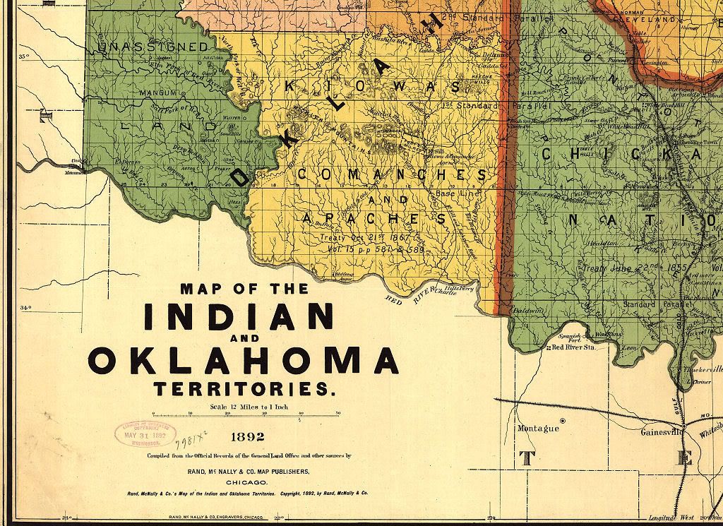
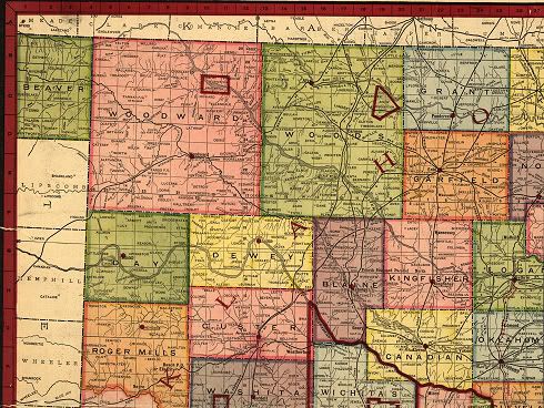
Northwest Quadrant. This map was received at the Library of Congress on May 31, 1892, but it doesn't bear an exact date. But, from the drawing, it appears that only two of the six land openings in Oklahoma Territory had occurred: (1) Land Run of 1889 on April 22 (Logan, Kingfisher, Oklahoma, Payne, and Cleveland counties); and (2) Land Run of 1891 on September 22 (Lincoln and Pottawatomie counties). The third, the 1892 Land Run on April 18 (Blaine, Dewey, Day – obsolete county combined with Ellis, Roger Mills, Custer, and Washita), does not appear to have occurred when this map was made.
Click the map below for a larger image, or
Click here for a 2400 x 1745 px view, or
Click here for a 4400 x 3200 px view
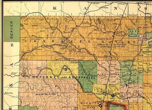
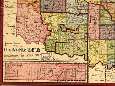
Southwest Quadrant. As is evident from the 1892 map's southwest quadrant, no land openings had occurred which affected this area. Ft. Sill is present, but neither Chickasha nor Lawton yet exist. Aside from the Atchison, Topeka & Santa Fe railroad along the east side, rail lines were not present in the southwest.
Click the map below for a larger image, or
Click here for a 2400 x 1745 px view, or
Click here for a 4400 x 3200 px view
Southeast Quadrant. Several rail lines are present and McAlester appears to be the focal point, including a segment of the Choctaw Coal & Railway line discussed in the Oklahoma County vicinity, above.
Click the map below for a larger image, or
Click here for a 2400 x 1745 px view, or
Click here for a 4400 x 3200 px view
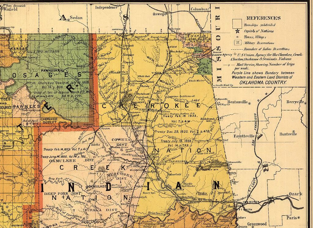
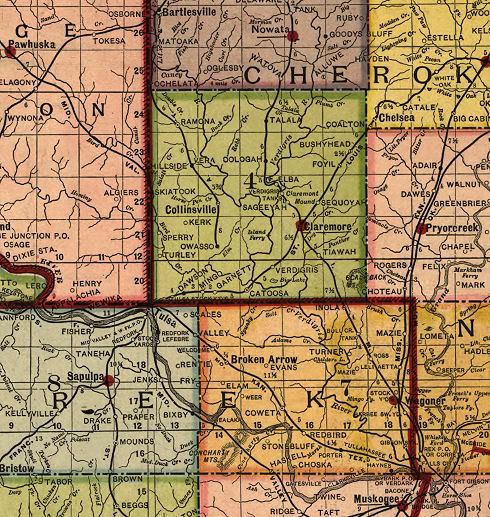
Northeast Quadrant. Fairly heavily populated with rail lines, concentrations were in Vinita, Claremore, and Wagoner.
Click the map below for a larger image, or
Click here for a 2400 x 1745 px view, or
Click here for a 4400 x 3200 px view
Go To Top
... Click here to read the full article and any comments ...
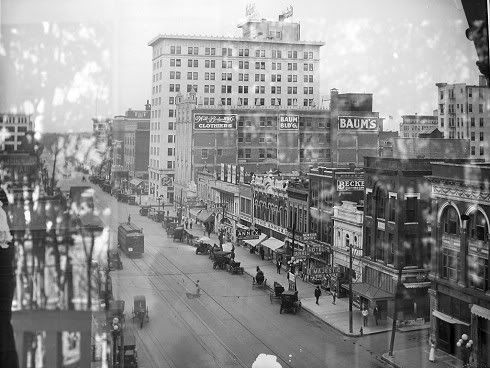
 Every now and then, one runs across something really special on the internet, something you've not seen before and just gotta have. When browsing through the Library of Congress stuff this past weekend, I ran across just such a thing, a marvelous high resolution map of Oklahoma in 1905, following a census which had just occurred, published by the Geographical Publishing Company of Chicago, Illinois.
Quick links in this article:
State Map Oklahoma County Vicinity Tulsa Vicinity
Black Towns State Quadrants Gazetter
ABOUT THIS MAP. The map was received by the Library of Congress in December 1905 and consists of two parts: (a) the map; and (b) the gazetter. City and town population is stated to be taken from a 1905 census however it is evident that county populations are from the 1900 census, as pointed out by Charles G. Hill, below.
For comparison with this map, see the 1892 Rand, McNally & Company high resolution map.
For a 4,096 pixel wide version of the map & gazetter below, click here
For a 2,048 pixel wide version of the map & gazetter below, click here
For a 1,024 pixel wide version of the map & gazetter below, click here
If you want to go the Library of Congress website and download your own copy, aside from what is presented here, feel free -- just click here. There, at the bottom of that page, you'll see that the very high resolution map can be downloaded, but you'll also see that the download is in JPG2000 format (JP2) -- and not a lot of us have graphic software that can read that format, particularly in its most recent iteration. Also, the JP2 file is HUGE -- 16.6 MB, measuring 8,624 x 13,422 pixels -- whoa!
Before locating this file, I didn't have graphic software that could read late versions of JP2 files, but I found some free software that would and would also convert it to more traditional graphic formats such as TIFF, etc. It works great and is totally free, and I recommend it. The software is IrfanView and can be downloaded here. After downloading and installing it, I learned that separate "plug-ins" were also required to read the LOC map file -- so, to save you such steps, after downloading and installing IrfanView, go here to download and install the plug-ins that are needed to read the LOC JP2 file. After doing both of those steps, after downloading the humongous LOC file, you will be able to view and/or convert the Library of Congress JP2 file, which has apparently become the "default" LOC graphic format for its more recent postings.
Either do the above, or read on here and copy and save what you want to your own computer of the product of my work with this file today. It's all gratis.
Despite the prominent Daily Oklahoman item at the top of this map, it is not the product of the Daily Oklahoman -- in this instance, the Oklahoman was buying advertising space in someone else's product and did not produce the map. Instead, the map was made in 1905 by the Geographical Publishing Company, located in Chicago. About such maps, a page at the LOC says this: Copyright and Restrictions
Most maps in the Map Collections materials were either published prior to 1922, produced by the United States government, or both (see catalogue records that accompany each map for information regarding date of publication and source). A few have permission from the copyright holders as noted in the descriptive record. The Library of Congress is providing access to these materials for educational and research purposes and is not aware of any U.S. copyright protection (see Title 17 of the United States Code) or any other restrictions in the Map Collection materials.
Note that the written permission of the copyright owners and/or other rights holders (such as publicity and/or privacy rights) is required for distribution, reproduction, or other use of protected items beyond that allowed by fair use or other statutory exemptions. Responsibility for making an independent legal assessment of an item and securing any necessary permissions ultimately rests with persons desiring to use the item. Gladly, this map was produced in 1905 and appears to have no current copyright restrictions and so, within the above definition, it appears to be freely usable by anyone that wants -- aside from selling the map as one's own, which I'm not doing. What I do in my blog is always free for the taking.
Now, let's get to the map. This article doesn't have much further text and the graphic images below are presented either as research tools for those so inclined or for those who "just like maps." You may have noticed that a horizontal white line or seam exists in the original LOC map -- I don't know if that was because it was "torn" or because it had been broken into segments. In the "map only" images below, I've edited the original graphic file to eliminate, as much as possible, the "white line" in the original map, taking care not to change the map itself.
THE MAP. The following images present sections of the LOC map, first for the entire state, then central Oklahoma, the Tulsa vicinity, Black Towns, and then map sections for each quadrant of the state. Gazetter elements follow the maps, showing populations and locations within the map.
THE STATE MAP. After the "state" map below, each "quadrant" state map is also show below in more particular detail. In all following maps, the "tear line" has been edited out to show better maps, even though though the original was not that way.
The Whole Map
Click the map for a 1,024 px wide view of the map, or
For a 3,000 px wide view of the map below, click here
For a 4,000 px wide view of the map below, click here
For a huge 8,367 px wide view of the map below, click here
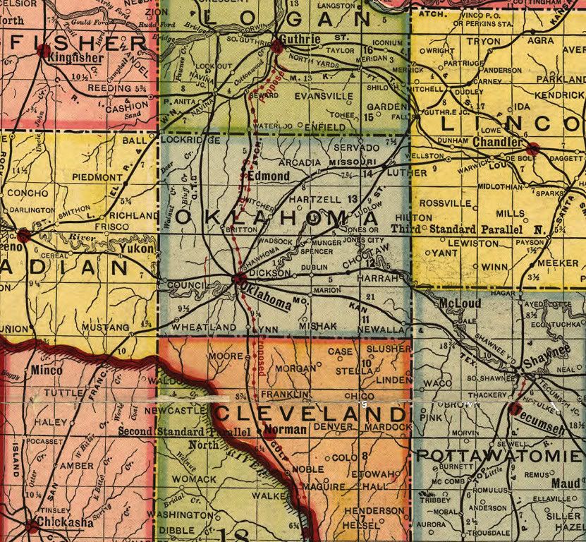
OKLAHOMA COUNTY & ENVIRONS. While all parts of the state map are presented below, Doug Dawgz focal interest is, of course, Oklahoma City. You will see no "road maps" in this 1905 map -- they didn't exist in 1905, at least not officially. But railroads did, big time -- they were the "roads" of the day.
The Oklahoma County Environment
Click the map for a larger view

Oklahoma County Only
Click Map for Larger View
Will you look at all of those rail lines converging on Oklahoma City in 1905! I'm going to ask my friend and railroad aficionado Dean Schirf to identify what all of them are after this original article is written! Notice the "red" dotted north-south line running through Oklahoma City -- that shows the location of the then proposed Oklahoma Railway Company interurban electric train line, proposed to run from Guthrie all the way down to Davis and over to Sulphur! While such a line was established, it didn't go south of Norman, but it did extend from Oklahoma City to El Reno in a part of the interurban not shown on the map. Look closely and you'll also see a short actual interurban line between Shawnee and Tecumseh, the latter then being the county seat.
A problem exists in the Gazetter which I was initially at a loss to explain. The Gazetter shows Oklahoma County's population as 25,915 but shows Oklahoma (City) to be 31,700. Charles G. Hill's Dustbury to the rescue! In a comment there, he said,
The problem with the Gazetteer is actually pretty simple: the county figures are from the 1900 Census — I verified the 25,915 figure from Census data — but the individual cities and towns are given 1905 estimates. (Population of OKC in 1900 was 10,037.) In 1910 Oklahoma County would have 85,232 people, which should give you an idea of how fast things were growing in those days. So, apparently comparing county v. city/town populations is like comparing apples and oranges.
Notice that quite a number of towns most of us have never heard of are present ... at least, I hadn't. In Oklahoma County, beginning in the northwest corner and going clockwise (more or less), notice: Lockridge, Servado, Hartzell, Ludlow, Wadsock, Munger, Dublin, Shawhoma, Dickson, Marion, Mishak, Lynn, and Wheatland. What happened to those communities?
Master-blogger Charles G. Hill provides at least some of the answers to the above -- see his nicely done Dustbury blog article to learn more about "Servado" and the rest! There, he says,
Obviously I don't know all these, but I'll take a stab at a couple of them, armed with some genealogical data, some 1900 Census numbers, and a little bit of experience. (I used to live near what used to be Dickson.) The grid on the Oklahoma County map shows township lines; each township is six miles square. The north-south lines, west to east, are present-day May Avenue, Bryant Avenue, Post Road and Indian Meridian; the west-east lines, north to south, are 164th, Wilshire and Reno.
Wheatland still exists, sort of: it has a post office (boxes only: 73097) and a Main Street, which is the extension of Newcastle Road southbound right before it runs into Council Road. Most of the telephones between Mustang and Will Rogers World Airport were considered by AT&T to be in the Wheatland zone (prefix: SHadyside 5).
Dickson was formerly Chaddick, and was located along the Rock Island line east of town. All that remains of the name, I think, is the Dickson Baptist Church at 2000 N. Spencer Road, within current Midwest City limits. (1900 population: 23.)
The Munger townsite, then four years old, was renamed Spencer in 1903, perhaps after the railroad (Santa Fe) came through, but apparently both sidings were retained. (This probably also explains Wadsock, just to the southwest.) These are all in the Crutcho township. (1900 population for Munger: 18.)
Hartzell was the name of the township just north of Crutcho; there was a post office there until 1906. It was named for its postmaster, as was Mishak, 13 miles to its south. There exists a Mishak Cemetery, between Douglas and Post along SE 59th; Mishak Baptist Church is nearby. (1900 population: Hartzell, 22; Mishak, 14.)
Lynn is almost, but not quite, in the right place for present-day Valley Brook. It's not listed in the Census.
Servado (1900 population: 42) lost its post office after 1905, and the mail went to Luther instead; this area appears to be unincorporated, and Luther has extended a half-mile-wide finger of its city limits as far west as Henney Road, presumably to prevent Oklahoma City from annexing it.
All the references I've seen to Shawhoma (not many) mention a railyard, which suggests that this might have been the stretch along the Santa Fe between 23rd and 36th. It never had a post office of its own, so far as I can tell.
Lockridge was technically in Logan County; it survived as a post office until 1928.
If I come up with anything else, I'll tack it onto the bottom. Good job, Chaz!
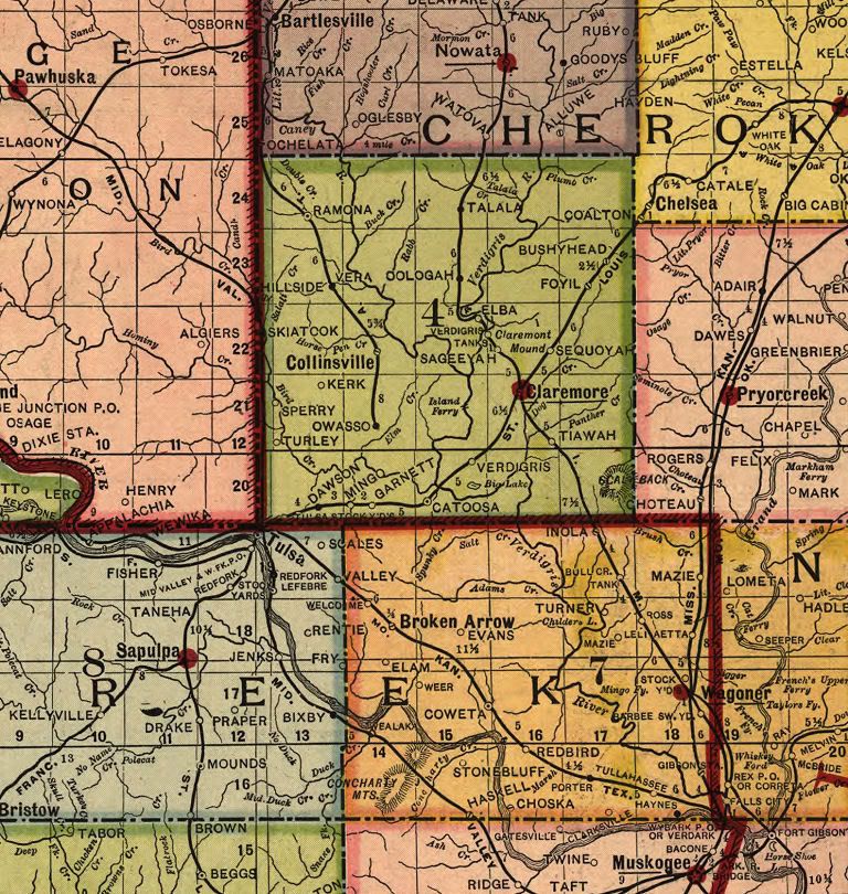
TULSA VICINITY. Unlike western Oklahoma with its six land openings between 1889 and 1901 in which Indian lands were opened for settlement and which resulted in a mass influx of mainly white but some black settlers -- (1) Land Run of 1889 on April 22 (Logan, Kingfisher, Oklahoma, Payne, and Cleveland counties); (2) Land Run of 1891 on September 22 (Lincoln and Pottawatomie counties); (3) 1892 Land Run on April 18 (Blaine, Dewey, Day – obsolete county combined with Ellis, Roger Mills, Custer, and Washita); (4) Land Run of 1893, also known as the Cherokee Strip Land Run of 1893, on September 16 (Garfield, Grant, Kay, Noble, Pawnee, Woods and Woodward counties); (5) Kickapoo Land Run of 1895, on May 3 (parts of Lincoln, Oklahoma, and Pottawatomie counties); and (6) the Land Lottery in 1901, August 1 (Comanche, Cotton, Tillman, Caddo, and Kiowa counties) -- eastern Oklahoma had no such experience. So, there were no explosive "born grown" cities or towns in Indian Territory, nor were the cities there as largely populated at this point in time, compared to Oklahoma Territory.
The Tulsa area was relatively small in population, except for Muskogee. The populations shown for the principal cities in the Tulsa vicinity were as follows: Bartlesville, 3,400; Nowata, 1,200; Collinsville, 1,600; Claremore, 2,150; Pawhuska, 2,500; Pryorcreek (Pryor), 875; Broken Arrow, 950; Wagoner, 2,500; Sapulpa, 2,600; Tulsa, 5,680; and Tulsa Stock Yards, 5,000. Note that Pawhuska was part of Oklahoma Territory, not Indian Territory. The largest city in the area was Muskogee with 14,200.
Tulsa Vicinity
Click the Map for a Larger View or
click here for a higher resolution view
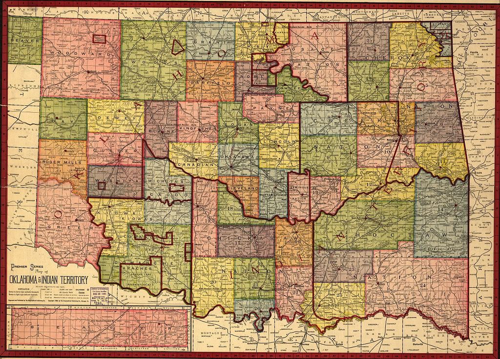
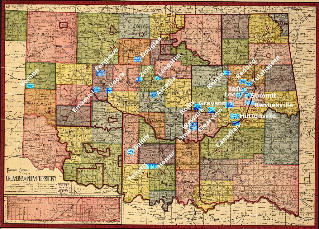
PREDOMINANTLY BLACK TOWNS. Many such towns existed in Indian Territory before that territory was divided into two territories. Later, during the various land openings in Oklahoma Territory several more predominantly African American towns came into existence, some of which survive to this day. The 1905 map and gazetter identifies the location and population of many but not all of these towns. In identifying the towns, I have relied on two sources: (1) The Oklahoma Historical Society's Encyclopedia of Oklahoma History & Culture in its article All-Black Towns, and (2) the African-Native American History & Genealogy Web Pages, more particularly its African Towns and Settlements of Indian and Oklahoma Territories page. While I'm not able to vouch for the accuracy of either, I have no cause to believe that either contains glaring errors – even though the OHS article does contain at least a few obvious mistakes, such as saying that Bailey and Boley were located in Oklahoma and not Indian Territory, the latter being correct. This New York Times article claims that 50 such towns existed, but does not name them or provide any corroborating data and the claim appears to be an exaggeration. Also, see this article by Hannibal Johnson. This Tulsa County Library web page contains some additional information and images.
The following edited version of the 1905 map shows the predominantly black towns that I've been able to identify. If I've made mistakes or omissions, comments would be appreciated and welcome.
Click on the map for a larger view
Click here for a 3000 x 2155 pixel view
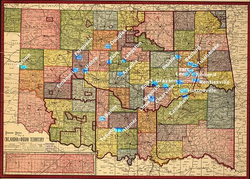
The following table identifies the towns contained in both the OHS and Genealogy Web Page sources. An ‡ indicates the OHS source; a pair of ** indicates the other; and a pair of ?? means I'm unsure of the location being the same as I've shown in the map - the only one is for Canadian Colored, not necessarily shown in the map, which merely shows "Canadian." However, the location of Canadian Colored is very near Eufaula, as shown in the map. All identified towns are not in both resources. The table indicates whether a town is shown in the 1905 map and/or 1905 gazetter, and, if stated in the gazetter, its population.
| Town | Terr | County or District or General Location | In Map | In Gaz | Population | | Arcadia ** | OT | Oklahoma | Yes | Yes | 125 | | Arkansas Colored ‡ ** | OT | Oklahoma | Yes | Yes | 125 | | Bailey ‡ ** | IT | 19 | Yes | Yes | 12 | | Boley ‡ ** | IT | 19 | Yes | Yes | 45 | | Bookertee ‡ ** | IT | NE of Weleetka | No | No | | | Canadian Colored ‡ ** ?? | IT | 12 | Yes | Yes | 522 | | Chase ** | IT | SE of Muskogee | No | No | | | Cimarron City ‡ | OT | Logan | No | No | | | Clearview ‡ | IT | 9 | Yes | Yes | 11 | | Douglas ‡ | OT | Garfield | Yes | Yes | 100 | | Emanuel ‡ | OT | Blaine | Yes | Yes | 10 | | Ferguson ** | OT | Blaine | Yes | Yes | 100 | | Grayson ‡ | IT | 9 | Yes | Yes | 15 | | Homer ‡ ** | IT | 21 | Yes | Yes | 75 | | Huttonville ‡ | IT | 12 | Yes | Yes | 7 | | Langston ‡ ** | OT | Logan | Yes | Yes | 300 | | Lee ‡ | IT | 10 | Yes | Yes | 20 | | Lima ‡ | IT | 13 | Yes | Yes | 33 | | Lincoln City ‡ ** | OT | Kingfisher | Yes | No | | | Mabelle ‡ | IT | Could not locate | No | No | | | Marshall Town ‡ ** | IT | NE near Verdigris River | No | No | | | North Fork Town ‡ ** | IT | Near Eufaula | No | No | | | Old Vinita ** | IT | 2 | No | No | | | Redbird ‡ | IT | 7 | Yes | Yes | 8 | | Rentie ‡ | IT | 8 | Yes | Yes | 7 | | Rentiesville ‡ | IT | 10 | Yes | Yes | 7 | | Sanders ‡ | IT | Could not locate | No | No | | | Summit ‡ | IT | 10 | Yes | Yes | 75 | | Taft ‡ | IT | 10 | Yes | Yes | 8 | | Tatums ‡ | IT | 20 | Yes | Yes | 25 | | Tullahassee ‡ | IT | 7 | Yes | Yes | 12 | | Udora ‡ | OT | Blaine | Yes | Yes | 7 | | Vernon ‡ | OT | Day | Yes | Yes | Not stated | | Wewoka ** | IT | 13 | Yes | Yes | 600 | | Wybark ** | IT | N of Muskogee | No | No | | | Zion ‡ | OT | Kingfisher | Yes | Yes | 8 |
STATE QUADRANT MAPS. The following images "quarter" the LOC map into Northwest, Southwest (including the Panhandle), Northeast, and Southeast quadrants. In addition to clicking on a map for a somewhat larger (1024 pixel wide) view, higher resolution version links are also presented.
Northwest
Click the map for a 1,024 px wide view or
For a 2,400 px wide view, click here.
Southwest & Panhandle
Click the map for a 1,024 px wide view or
For a 2,400 px wide view, click here
Southeast
Click the map for a 1,024 px wide view or
For a 2,400 px wide view, click here

Northeast
Click the map for a 1,024 px wide view or
For a 2,400 px wide view, click here
THE GAZETTER. As noted earlier, an obvious discrepancy exists when comparing county v. city or town population data in the Gazetter (Oklahoma County v. Oklahoma [City] population). As already said, Charles G. Hill of Dustbury fame provided the reconciling information in a comment to his own article -- that "county" data is from the 1900 census but that city and town data is from the 1905 census. So, take care when comparing county and city/town populations. The Gazetter shows locations and 1905 populations for those cities and towns reflected in the map. The map presents that information by the existing federal territories, Oklahoma and Indian Territory. Railroads within each territory, Native American tribal and other information are also shown.
OKLAHOMA TERRITORY. In these days, Oklahoma County or City (actually, "City" was not part of the city's name in 1905) may not have been the big kid on the block, although, as mentioned above, the Gazetter shows Oklahoma (City's) population as of 1905 was 31,700 but shows Oklahoma County's population as 25,915, but Mr. Hill informs that the county population was based on the 1900 census. It was a surprise to see that the county shown as having the largest population was Woods County (which would be in 1900, according to Mr. Hill)!
| Counties over 20,000 | 1900 Population - see above | | | Woods County (Alva) | 34,975 | | | Lincoln County (Chandler) | 27,007 | | | Pottawatomie County (Tecumseh) | 26,412 | | | Logan County (Guthrie) | 26,563 | | | Oklahoma County (Oklahoma) | 25,915 | | | Kay County (Newkirk) | 22,530 | | | Garfield County (Enid) | 22,076 | | | Payne County (Stillwater) | 20,909 | |
Railroad companies serving the territory are shown to be: Atchison, Topeka & Santa Fe; Chicago, Rock Island & Pacific; Denver, Enid & Gulf; Fort Smith & Western; Kansas City, Mexico & Orient; Missouri, Kansas & Western; and St. Louis & San Francisco.
Click the image below for a readable view
INDIAN TERRITORY. Indian Territory was not then divided into "counties" -- instead, numbered "districts" are shown, 26 of them. District populations are not shown but city and town populations were. Strictly speaking, only one, Muskogee, was above 10,000 at 14,200. Tulsa was 5,680, though nearby "Tulsa Stock Yards" (between Tulsa and Sapulpa) had 5,000. McAlester had 2,500, but nearby South McAlester added another 7,000. Tribal populations were quite large, those over 40,000 being shown below:
| Indian Nations Over 40,000 | 1905 Population | | | Chickasaw (Tishomingo) | 139,260 | | | Cherokee (Tahlequah) | 101,754 | | | Choctaw (Tuskahoma) | 99,781 | | | Creek (Okmulgee) | 40,674 |
After the Creek Nation, the drop off was pretty steep -- next was the Seminole Nation at 3,786. The Gazetter does not make clear whether the tribal populations were from the 1905 census estimates or were based on the 1900 census.
An abundance of railroad companies was present: Arkansas & Western; Atchison, Topeka & Santa Fe; Chicago, Rock Island & Pacific; Fort Smith, Poteau & Western; Kansas City Southern; Kingston & Choctaw Valley; Midland Valley; Missouri, Kansas & Texas; Misouri, Oklahoma & Gulf; Missouri & Louisiana; Poteau Valley; St. Louis, Iron Mountain & Southern; and St. Louis & San Francisco.
Click the image below for a readable view
That's it! Enjoy the map!
Go To Top
... Click here to read the full article and any comments ...
This article received a major revision on 6/11/2008 to add several new pics and newspaper articles on downtown theaters gone by. It was earlier updated on 11/5/2006; 4/28/2007 (added links and some Midwest images); and 9/24/2007, a major revision which replaced many pics with better scans and added many not previously included. The focus of this major revision is movie houses and movies beyond the memories of most everyone alive today.
Overholser/Warner Criterion Midwest
Liberty/Harber/Cooper State Centre Older Theaters
Metropolitan/Palace Folly Dreamland/Capitol Empress Majestic Rialto
Others Ads In The 1920s Ads In July 1943 Bricktown Harkins
Unless otherwise stated, you can click on the pics below for larger images – they will open in a separate window.
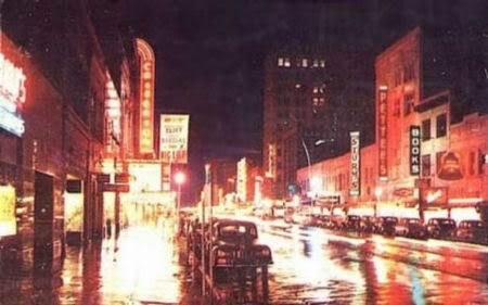
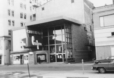
Before urban shopping centers and before the Pei Plan, downtown Oklahoma City was the center of shopping ... and, of course, the movies! If you'd want to see 2001: A Space Odyssey, that's where you'd go – downtown, and, in this instance, the Cooper Cinerama (immediately north of the Colcord Hotel).
So, step back about 30-35 years and even further back in time while you still could, and let's go downtown to the movies! OK! But, where to go?
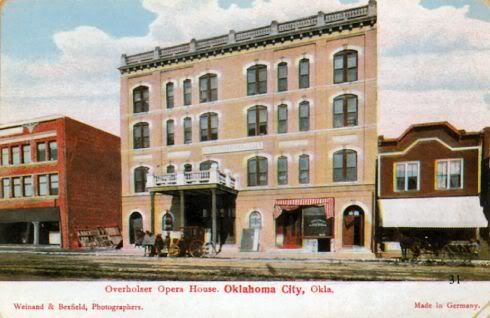
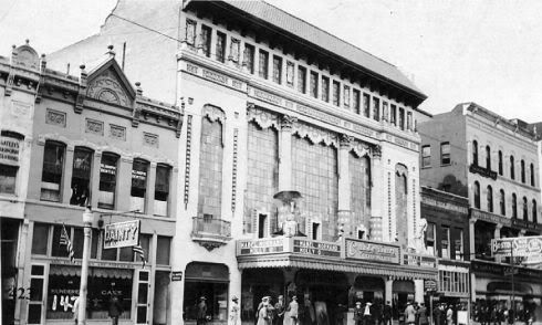
The Overholser Opera House/Orpheum/Warner. Originally the 1903 Overholser Opera House at 217 W. Grand (Sheridan), notables such as Sarah Bernhardt and Lillian Russell performed there.
From Vanished Splendor (I) (next 2 pics)
The Overholser Opera House (1903)
Around 1911, to the West (left) of the Colcord

From Vanished Splendor II
A 1921 Renovation Made It the Orpheum
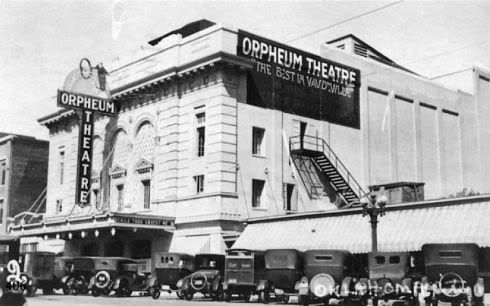
From Historic Photos of Oklahoma City, around 1925

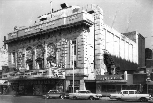
In 1928, being aquired by Warner Brothers, it became the Warner. In the mid-1950s, Warner Bros. renovated the building to become Oklahoma City's first Cinerama theater, as show in the pic from http://cinerama.topcities.com/warnerok.htm), below. Internet sources vary as to when this was done – compare http://cinerama.topcities.com/warnerok.htm with http://cinematreasures.org/theater/12888/ ... Cactus Jack's remarks).
The Cinerama "Extreme Makeover"
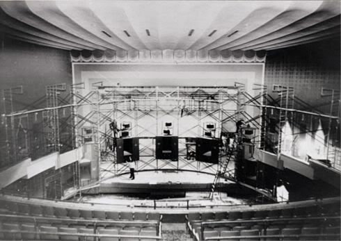
The original seating is reported to have been about 2,400 ... the Warner Brothers changeover (with wider seats) dropped it to about 2,000 and the Cinerama make-over reduced it more. Sad to say, it was not my privilege to have set foot in this, the granddaddy of downtown movie houses. Below, it is shown featuring the 1956 Lowell Thomas' Seven Wonders of the World Cinerama production. The theater closed in 1964 and today it is part of the Center City Parking garage and lot.
From my photo collection, image in 1957
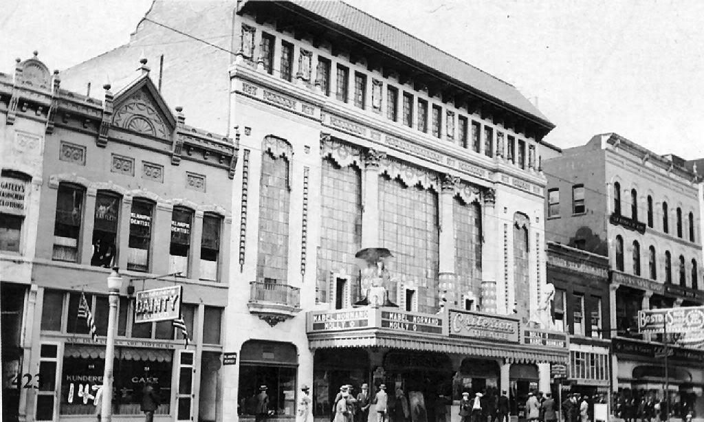
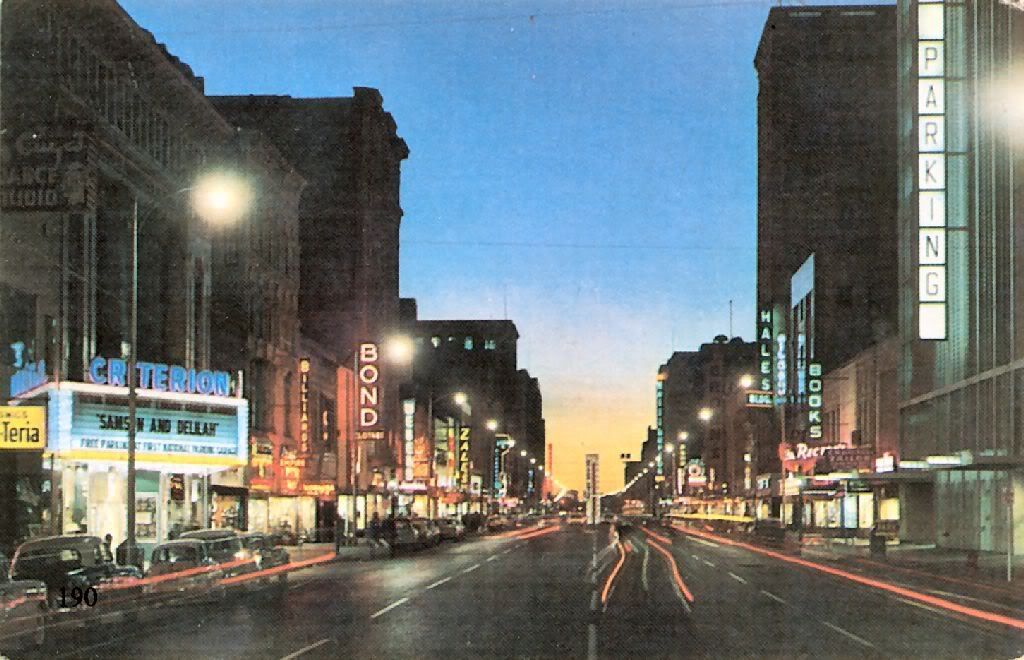
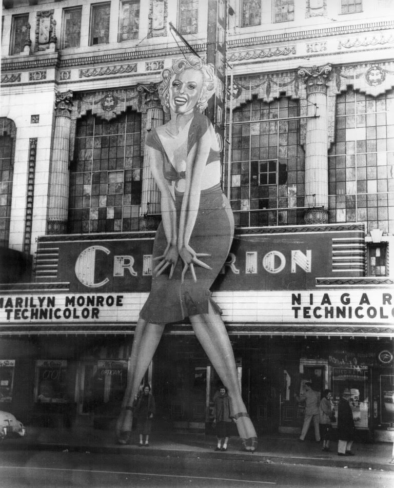
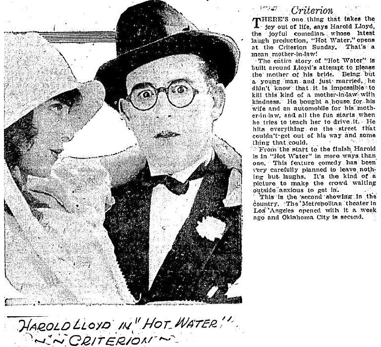
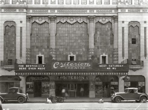
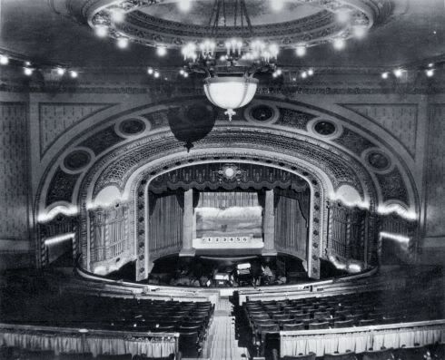
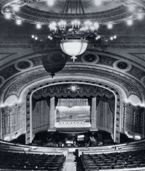
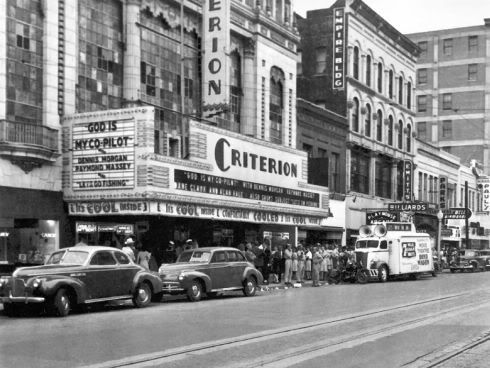
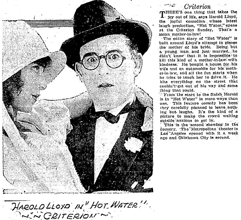
The Criterion. The Criterion, designed by Boller Brothers and featuring a French style lobby and auditorium with an art deco mezzanine, was operated by the Paramount/Publix Theatre Circuit. Built in 1921 at 118 W. Main, it originally seated 1,900 but later remodelings reduced its size to 1,650. It was destroyed in 1973. For some nice interior and exterior pics, see Jeff Chapman's CinemaTour Criterion Page. Several other images appear below.
From Vanished Splendor III in 1922
From the Okc Metropolitan Library System in 1928
From Oklahoma City: 2nd Time Around (next 2 pics)
The date is not stated but I'm guessing in the 1930s
A cropped view of the same image
From Historic Photos of Oklahoma City in 1945
From Vanished Splendor II in 1949

Here's a pic from 1950 (click on the pic for a larger cropped view)
On February 17, 1953, Marilyn Monroe in Niagara
From my photograph collection (next 2 pics)

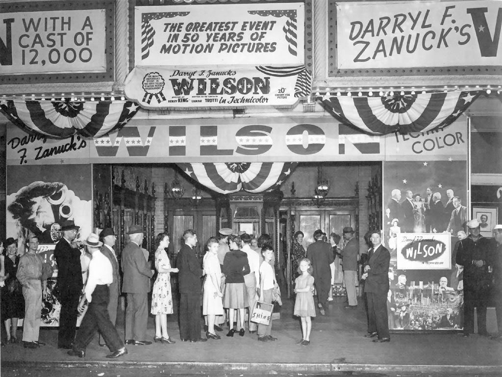
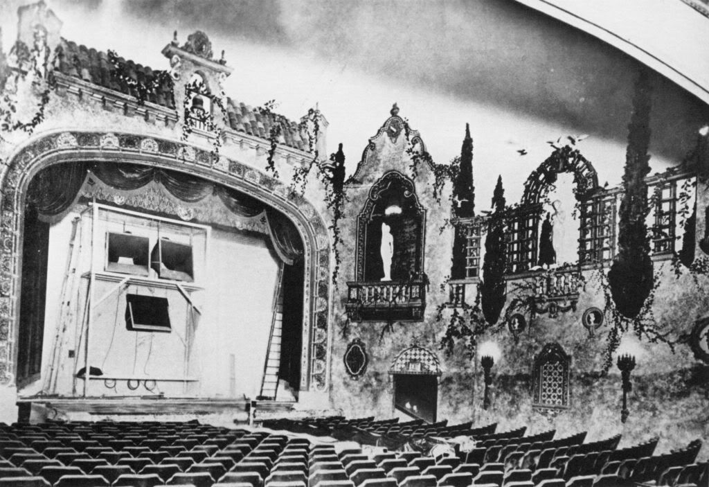
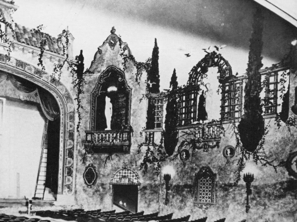
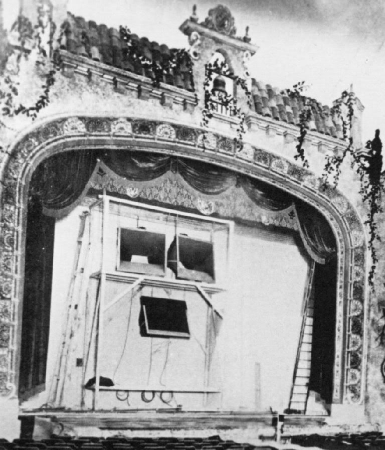
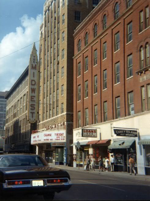
The Midwest. Ahhh ... visiting Oklahoma City in the mid-to-late 1950's as a teenager, my favorite was the Midwest, 16 N. Harvey, with its multiple balconies ... 5, I think, but certainly at least 4 (note: I've not been able to confirm the comment by John (that the Midwest had only one balcony) in the Comments, below, but I can't say that he is wrong, either, even if my childhood memory is different). Like the Warner, the Midwest was owned by Warner Brothers. It opened in 1930, seating capacity was around 1,600 - 1,700, and closed in 1975.
From Historic Photos of Oklahoma City (next 3 pics), 1st in 1946
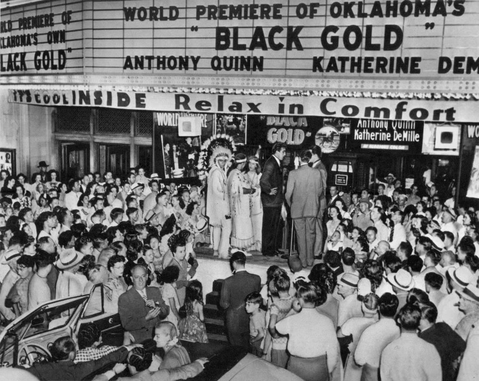
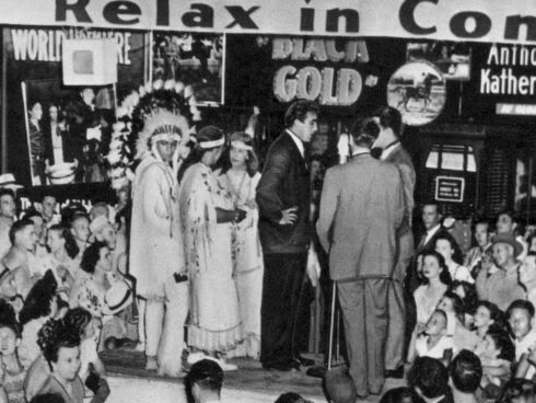
1947's World Premier of "Black Gold", Anthony Quinn in the middle
It's about the Oklahoma horse that won the Kentucky Derby

A cropped view showing Anthony Quinn
From Jeff Chapman's CinemaTour Midwest Page
Click the above link for many nice images, inside and out
The Midwest in 1970
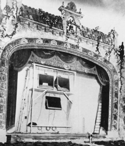
From Oklahoma County: Heart of the Promised Land (next 3 pics)
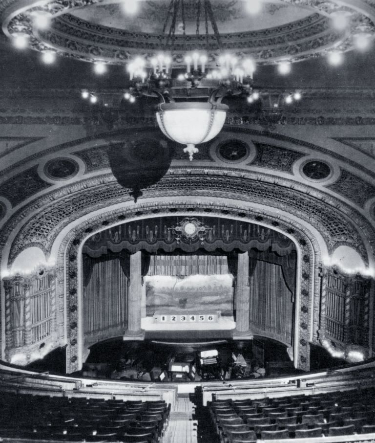
Auditorium Views, Probably during the 1920s-1930s (new scans 10/22/2007)


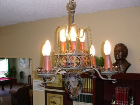
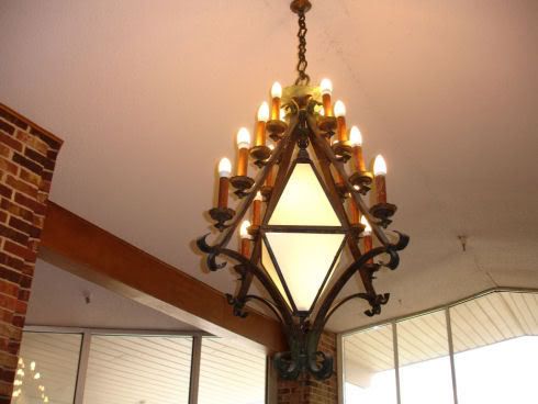
Some Preserved Lighting Fixtures
Norman Thompson kindly supplied these images to me.
His mom purchased the fixtures from the Midwest before it was demolished.
The 1st image shows a fixture from the theater's mezzanine
but I'm not sure where the 2nd was located.
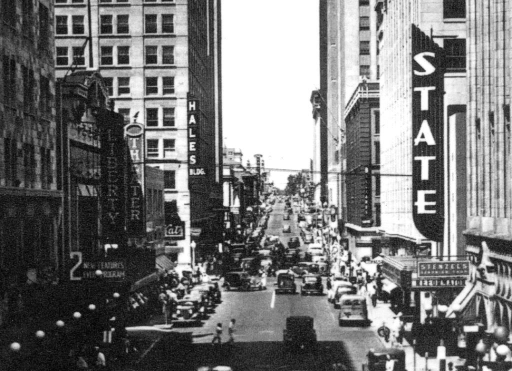
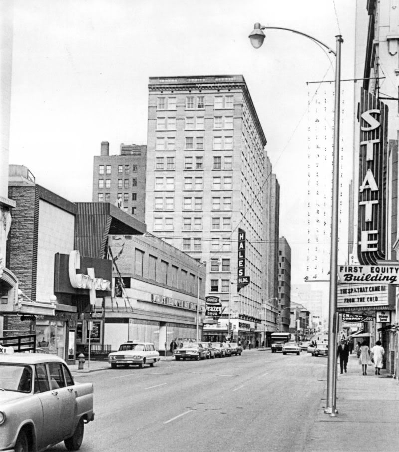
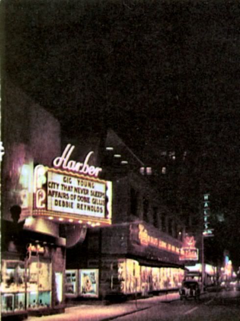
The Liberty/Harber/Cooper Cinerama and The State. These theaters were in the 100 block of North Robinson and faced each other, the Harber on the west and the State on the east, as shown in the images below.
From Historic Photos of Oklahoma City (next 2 pics)
Around 1937, after the State was constructed

A cropped view of the above pic

Same general view from Vanished Splendor III in 1953
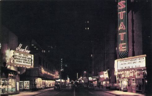
From Oklahoma City: 2nd Time Around
Around 1966 (The Spy Who Came In From The Cold
was released in December 1965)

The Liberty/Harber/Cooper. The theater on the left, above, was originally the Liberty, built in 1915. It eventually became the Harber, and, finally, the Cooper Cinerama in 1960, seating 1,200. It closed in 1975.
From My Photo Collection, 1926 (rescanned 9/22/2007)
From Historical Photos of Oklahoma City around 1928
The oil derrick still sits atop the Petroleum Building
In 1953 (crop from the Vanished Splendor III pic, above)
From Jeff Chapman's Liberty Theater Collection in the 1960s
(Larger image not available)
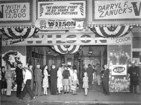
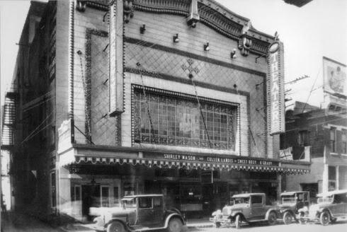
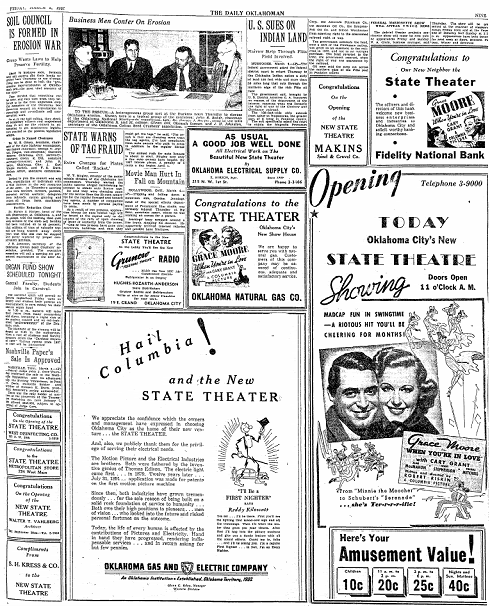
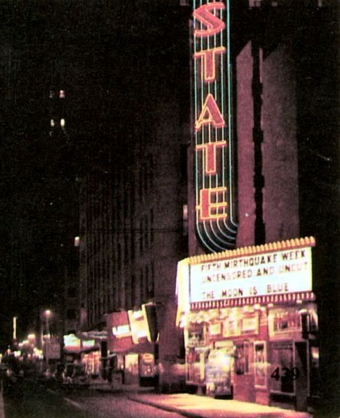
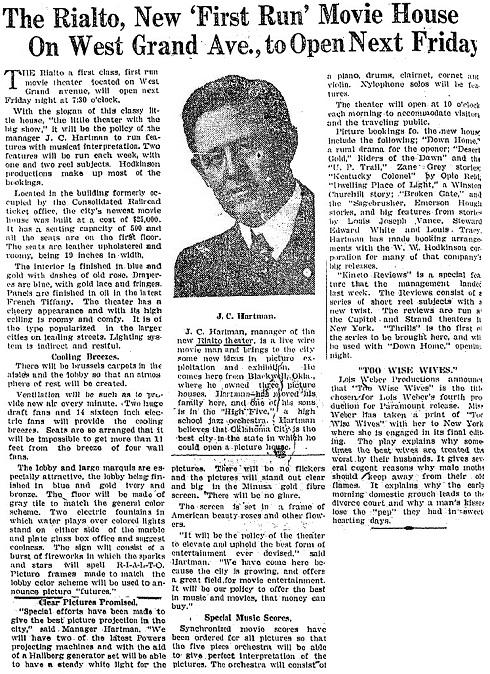
The State. The State opened on March 5, 1937, as shown by the Oklahoman article below. A Columbia movie house, its first movie was When You're In Love with 1st billing to Grace Moore, 2nd to Cary Grant.
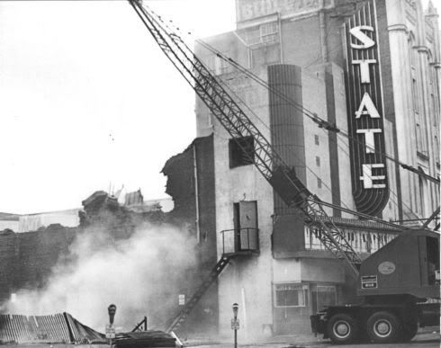
According to internet sources, it seated 1,100 to 800 (reports vary). As said above, it was initially a Columbia movie house but the historical references I've found are pretty sketchy so I don't know if linkage lasted until the State closed in 1970 and was demolished in 1971 during urban renewal (see below). Aside from a couple of postcards along Robinson (already shown which really serve no purpose other than to show the theater's location), the only half-way decent image I've found while the State was alive is the same image from Vanished Splendor III, cropped below to show the State on the east side of Robinson.
Sadly, the best image of the State's entry I've found when it was being demolished in 1971 as part of the massive urban renewal downtown destruction.
From Oklahoma City: 2nd Time Around
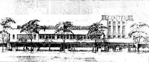
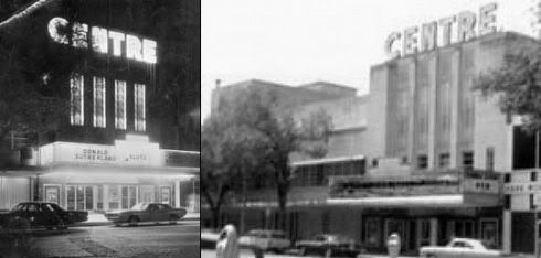
The Centre. The 1,600 seat Centre Theater designed by the Kansas City Boller Brothers firm was built in 1947. Eventually, after it closed (reports vary as to date, mid to late 1970's), it became the kernel for the Oklahoma City Museum of Art (but as part of a much larger structure) and a small nicely done stadium style theater (called the Noble Theater ... see click here for detail ... is present in the complex. That latter-day theater screens independent, foreign language, and classic films on Thursdays through Sundays. For movies about to be shown, click here. I've not found any particularly good images of the Centre so far. But, see Jeff Chapman's Noble Theater Collection at CinemaTours for some interior and exterior views near or at the theater's end.
An artist's rendering in the Oklahoman (with the theater's name misspelled) and a couple of cropped-together smaller images appear below. Larger images are not available.
Older Downtown Theaters. While the above are the theaters most of us old enough often remember, others existed downtown well before almost all of us were born. In more or less chronological order, most of those early-day theaters are shown below.
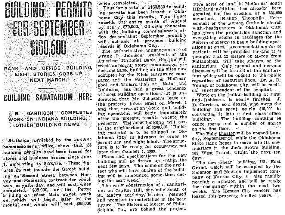
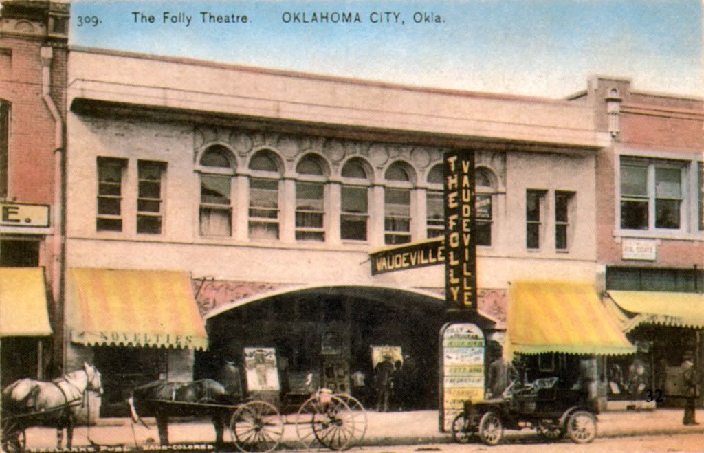
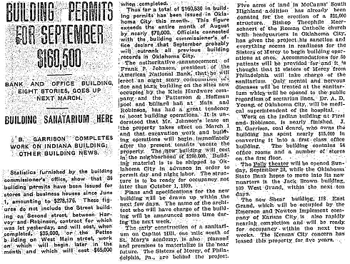
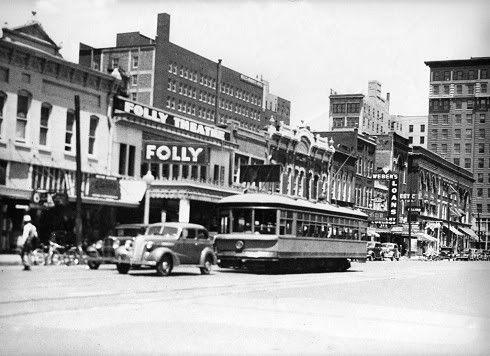
Folly. The Folly opened in 1908, two buildings east of where the Baum building would be built in 1910 on Grand (Sheridan). The September 20, 1908, Oklahoman article gives a description:
Credit Vanished Splendor (I) by Jim Edwards and Hal Ottaway

In the 1940s
Credit Whistlestop Trains/Vintage Rail Photos
Additional images of the Folly are shown in the Majestic Theater photos, below.
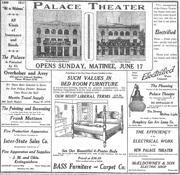
Metropolitan. This theater opened in 1909 at 320-322 W. Main, south of the Terminal Building (Oklahoma Railway Company's building and trolley terminal).
Credit Vanished Splendor (I) by Hal Ottaway & Jim Edwards
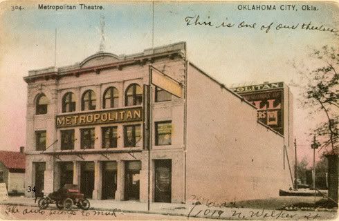
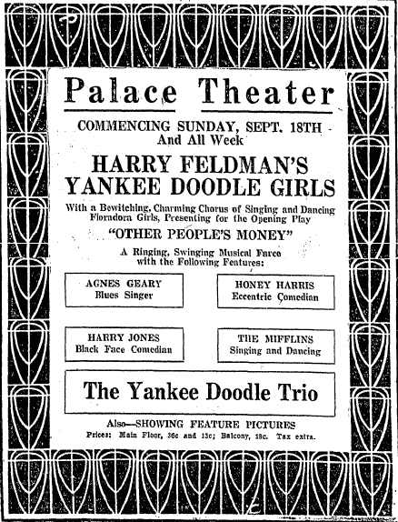
The theater had its own stock company but also engaged early day notable companies like the North Brothers Stock Company. But, in 1917, it became the Palace Theater, as shown below:
A June 17, 1917, ad showing the change

A September 18, 1921, Oklahoman Ad
(larger image not available)
The theater received damage when dynamited in 1929, perhaps arising out of a union shop agreement with other city theaters to which the Palace would not give its assent. A July 7, 1929, Oklahoman article reported as follows:
Larger image not available
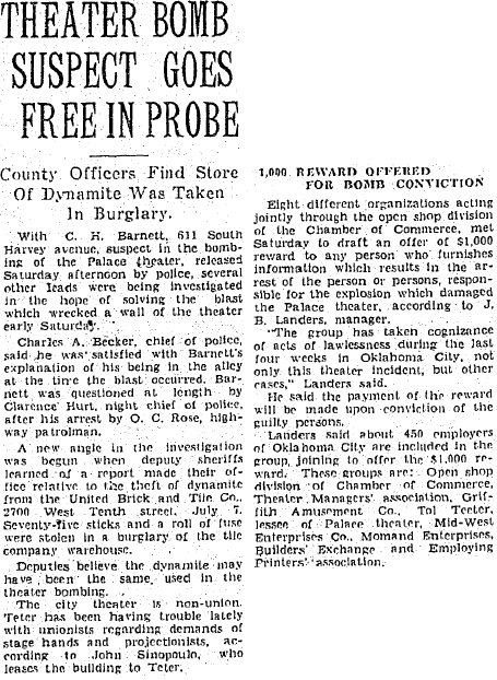
About the theater, Vanished Splendor (I) says,The theater opened in January 1909. One of the early day stage hands was Lon Cheny, who went on from Oklahoma City to leave his mark on the world stage. Labor problems surfaced in 1929 because the Metropolitan was the only non-union theater in town, and in July of that year the structure was badly damaged when it was dynamited. It was condemned and torn down in 1935 as part of the WPA job program in the city. Articles in July 1935 Oklahoman issues confirm that.
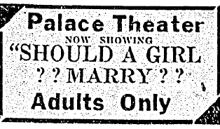
After the dynamiting and before its destruction, at least some movie fare at the Palace had become "adults only" as is shown below - larger images are not available for the next two ads:
February 4, 1930
March 22, 1931 - also see the Rialto, below
The Dreamland (later the Capitol). The earliest version of the Dreamland was around 1907 in a different location. The one which became a downtown fixture, though, opened in September 1911 at 308 W. Main, two buildings west of the Mellon Department Store. In 1920, it was remodeled and became the Capitol Theater.
Credit Larry Johnson's Historic Photos of Oklahoma City
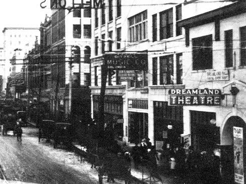
In the 1920s as the Capitol Theater
Credit Whistlestop Trains/Vintage Rail Photos
In the foreground, this photo shows the elegant Mercantile Building and
further away the ornate Patterson Building as Oklahoma Railway Company trolleys exit the downtown terminal
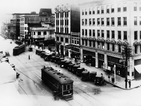
Crop of the above focusing on the Capitol Theater

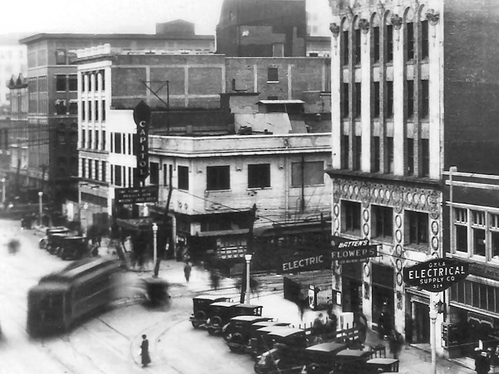
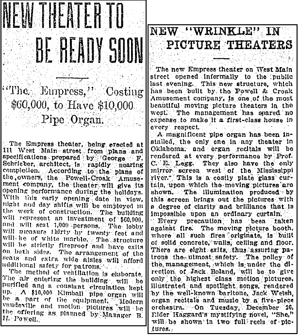
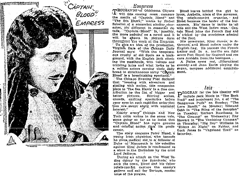
The Empress. This theater was located at 111-113 W. Main (north and across street from the Criterion) and it opened in 1911 as shown by the November 26, 1911 and December 4, 1911, Oklahoman articles below.

From Vanished Splendor III around 1923
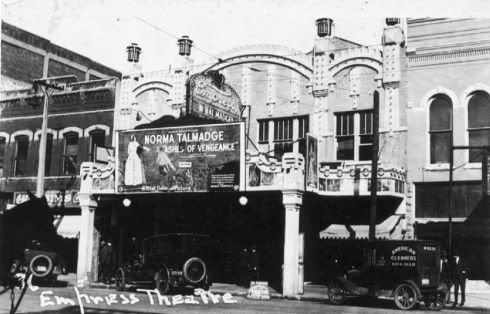
From Historic Photos of Oklahoma City in 1926
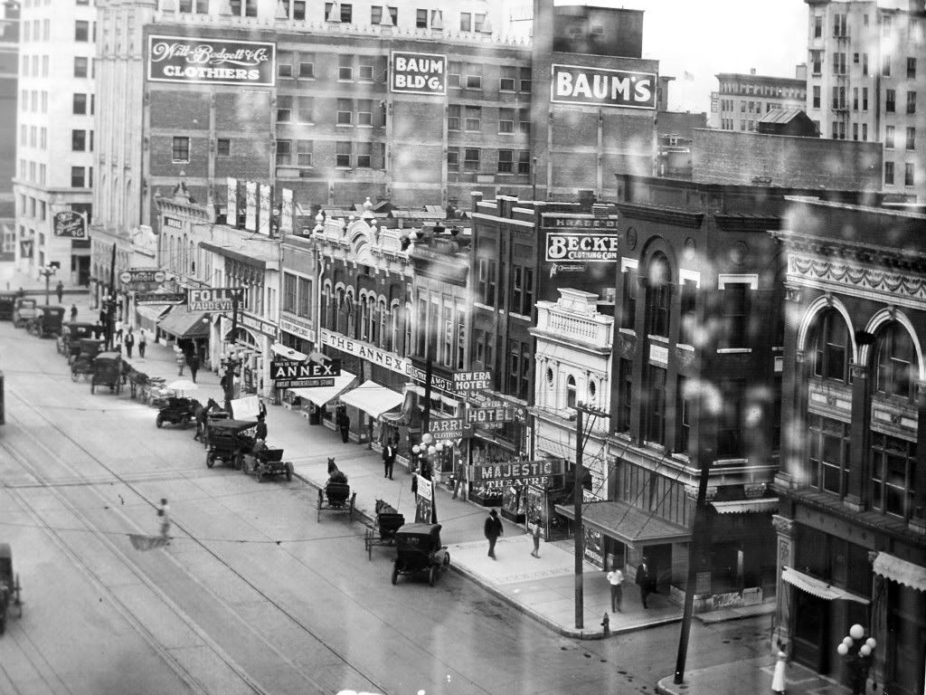
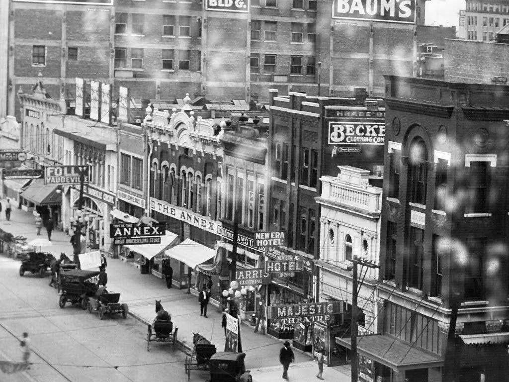
The Majestic. Opening in 1911 along with the Empress, the Majestic was located at 111 W. Grand, two buildings east of the Baum.
Both the Folly and the Majestic are shown on Grand Avenue, looking west, courtesy of Ms. Elaine Schuster, below. I was unable to avoid glare/reflection from the glass when taking the photo, but it's still a great photograph.
The full block showing the Baum Building and Colcord Buildings
Narrowing the view

Focusing on the Folly and Majestic Theaters

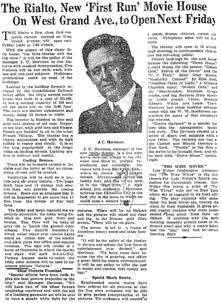
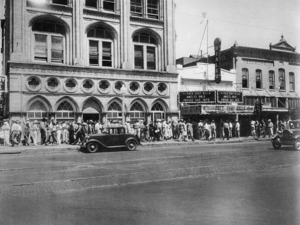
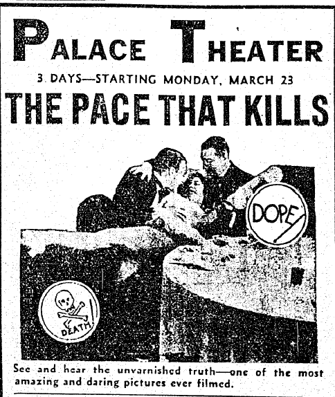
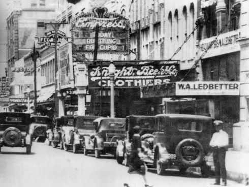
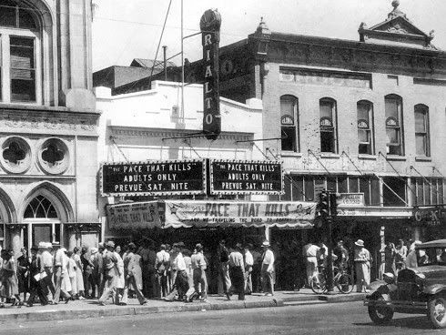
The Rialto opened in April 1921, immediately east of the Baum Building at 131 W. Grand (Sheridan).
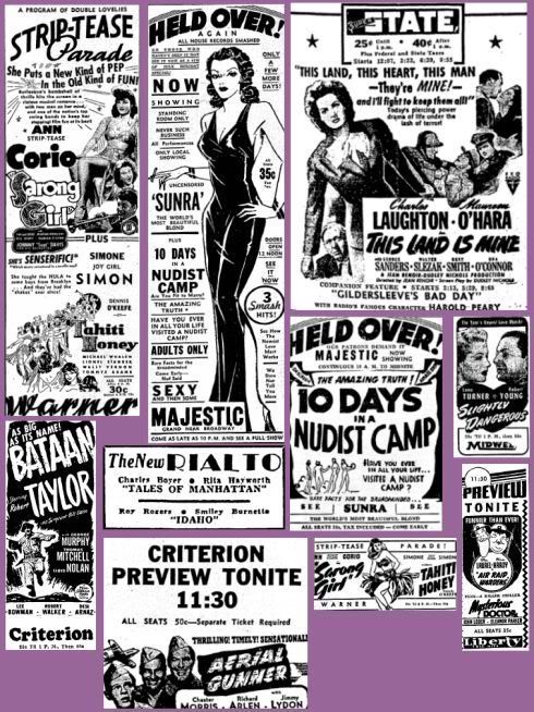
Despite its "first class" origins, by the mid-1930s, that had apparently changed, if the adults only movie, The Pace That Kills, provides an indication - see the last Palace ad, above. Though the movie was not described as particularly uplifting, it drew a good crowd on this day!
Credit Larry Johnson's Historic Photos of Oklahoma City

Zooming In ...
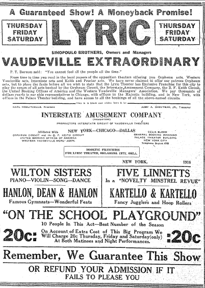
Others - the Lyric & the Isis. These two other downtown theaters shown in various Oklahoman ads during this period. I've not located a photo for the Lyric. The Lyric was described in the following Oklahoman ads as being at the corner of Grand (Sheridan) and Harvey - larger images for the next two pics are not available.
May 24 (left) and May 30, 1908 ads
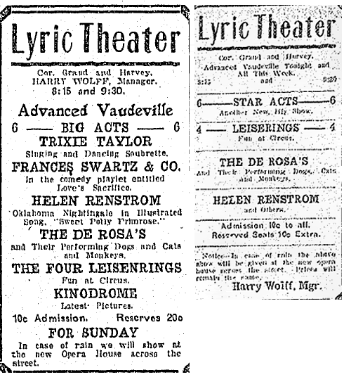
May 4, 1916, ad
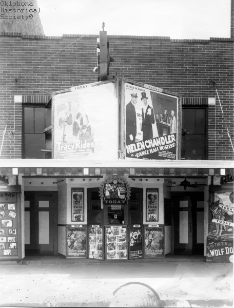
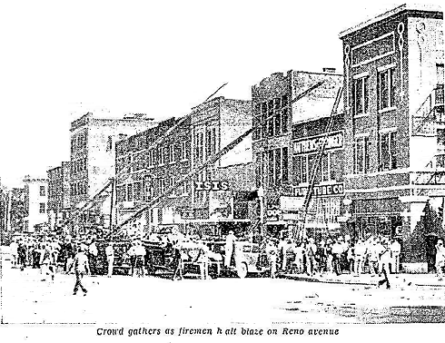
Whether the Lyric played movies, I don't know. It apparently moved at some point to Robinson since a September 1, 1930, Oklahoman article said, "The old Lyric theater was torn down to make way a few years ago for the 12-story Perrine building." The Perrine, now Robinson Renaissance, was built at the southwest corner of Robinson & NW 1st (Park Avenue) in 1927. The Isis was located at 121 W. Reno and existed by September 1921. It apparently ran only "B" or "second-run" movies and perhaps some light porn during its existence -- the last mention that I could locate in the Oklahoman was on January 15, 1947, describing its ownership (Griffith Theaters) and management. I could not find any Isis "ads" after the early 1930s. An Oklahoma Historical Society image shows the frontage and a not-very-good image from the September 11, 1933, Oklahoman shows the building, being next door to another building being attended to by Oklahoma City firemen, both below. Some unsubstantiated discussion about the Isis is at the Cinema Treasures website.
Oklahoma Historical Society circa 1936
(according to this website, Dance Hall Hostess was a 1933 movie,
and this website shows Tracy Rides as a 1935 movie)
(larger image not available)
There are others and I'll be adding them shortly, e.g., the Broadway/Capital, Home State, Gem, Bijou, Reno, Pix, Gaiety, and Strand/Olympic. The Oklahoman's ads do mention other theater names, but they were not located downtown such as the 1928 Ritz (1020 E. 13th - NE 13th & Stonewall), the 1928 Victoria (northwest corner of Classen & NW 18th), the late 1920's Circle (2510 S. Robinson), and the 1919 Aldridge in Deep Deuce at 303-305 N.E. 2nd.
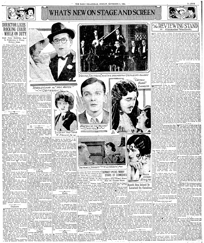
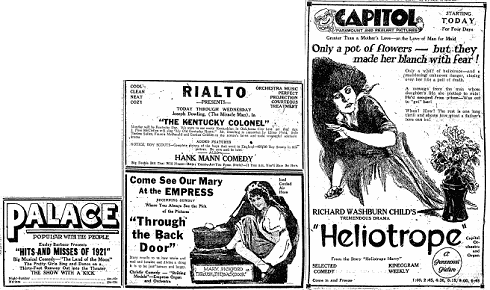
1920s Advertisements. O.K., let's say you are about 100 to 90 years old as this article is written in 2008. What movies would you typically see if you went downtown to the movies in the early 1920s? They weren't "talkies" yet and all was black and white on a small square screen, and they "fickered," but it is evident that such movies without speech were as popular as the color high resolution wide-screen sometimes computer generated with great sound movies are today. A couple of examples are shown below.
May 29, 1921, Daily Oklahoman
(click the image for a readable high resolution view)
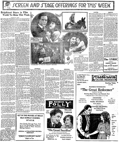
Ads on the page following the above
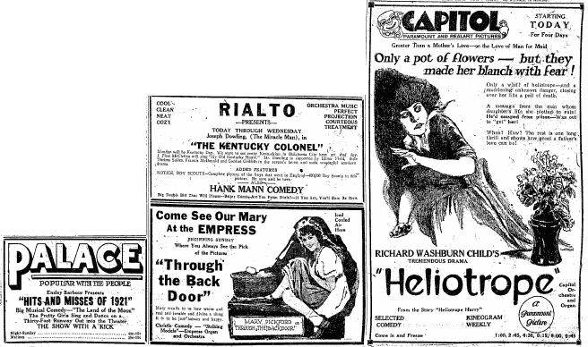
I'll give more detail from the following November 2, 1924, Oklahoman article . . .
Here's the detail
At the Rialto & Folly
(Larger image not available
At the Empress and Isis (to be described later)
At the Criterion
At the Liberty
At the Capitol
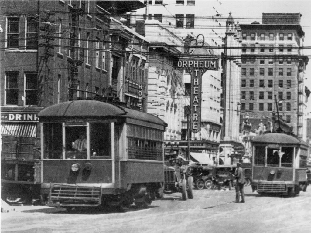
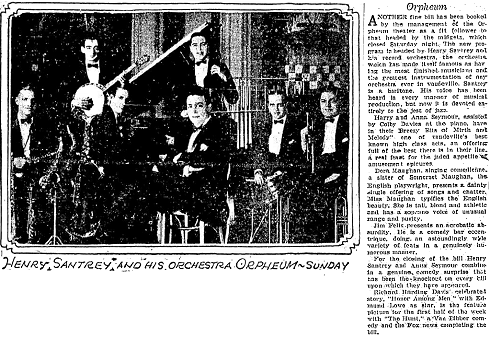
At the Orpheium
Movies On My Birtdhday. O.K. What if you were a young guy like me, born in 1943! Ever diligent in searching for clues that might help explain certain elements of my personality, since I was born at St. Anthonys in early July 1943, I thought that Oklahoman ads as to what was playing downtown might give some insight! And, indeed, they did! Here's what I found — instant karma!
In any event, all of the above theaters were either closed or destroyed at least by the mid-1970's — I can't yet identify which theater was, "The Last Picture Show," but it doesn't matter — there was no place downtown to go.
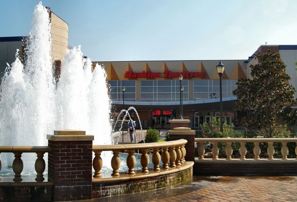
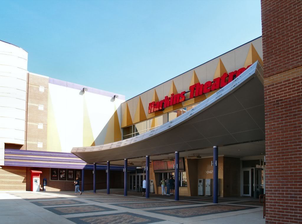
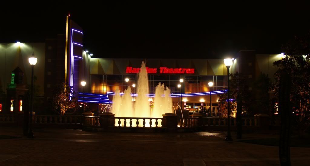
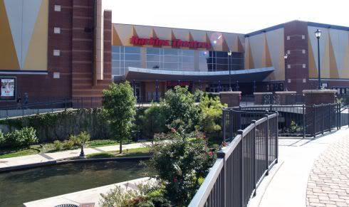
Harkins Cinema & Cine Capri. After the last of downtown's grand or not-so-grand movie houses closed, it would not be until 2004, about 30 years later, that one could say, "Let's go downtown to the movies!" and have any place to go. Enter Harkins Cinema & Cine Capri on October 1, 2004, with the opening of the Harkins Cinema & Cine Capri at 150 E. Reno in Bricktown. Hosting 16 screens, including Cine Capri (with a 70-foot wide screen, 600 seats, 144 speakers and 40,000 watts of power and pure digital sound, the Cine Capri is the largest cinema screen in Oklahoma City — it even has stage curtains and curtains against the walls, for god's sake) — and located in an area that old-time-downtown-movie-goers would never have dreamed possible, that run-down area which was once called, "the warehouse district," in its best day which by the 1960s were well within the rearview mirror.
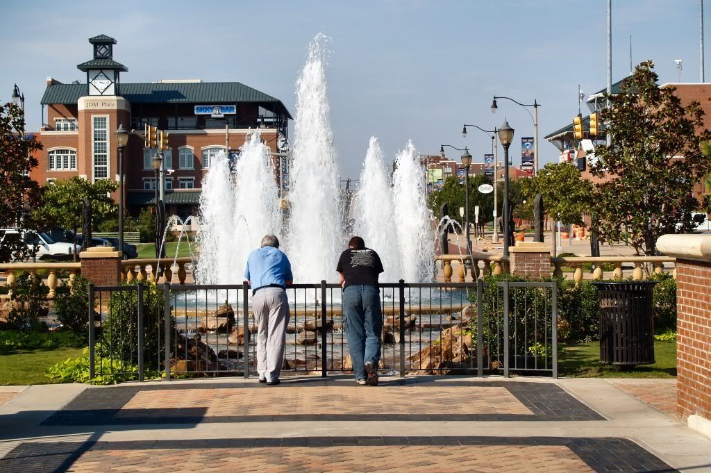
Though a long time coming, patience paid off — this element of Bricktown had been promised to occur 8 years earlier than it did — the Harkins Cinema & Cine Capri has become a great downtown destination. They've even got a child care facility not to mention the other nearby things to do – a walk on the canal, Bricktown entertainment and dining, and the nearby Oklahoma Land Run Monument (saluting the Land Run of 1889 that saw the birth of Oklahoma City which will feature 46 "heroic-size" bronze pieces and will stretch more than 300 feet – it's just south and west a few hundred yards away from the theater). On one occasion, coming out of the theater around 10 pm, a mime who looked remarkably like a bronzed Will Rogers was seen entertaining the kids and wooing the women by the Centennial Fountain which is just north of the Harkins.
The Harkins is a family owned corporation headquartered in Phoenix and I'm mighty glad that it chose Oklahoma City as its first venture beyond the borders of the Grand Canyon State! See http://www.harkinstheatres.com/redharkins.asp and http://www.harkinstheatres.com/danharkins.asp for the history of this fine organization. They've proven to be good local citizens, too, most recently being one of the hosts and sponsors of Oklahoma City's 6th Annual deadCENTER Film Festival, June 7-11, 2006. See http://www.deadcenterfilm.org/venueandpress06.html.
Except for the last, I took the images below on September 24, 2007, in the mid-afternoon when not much was going on.
On Mickey Mantle Drive Looking South Across Reno
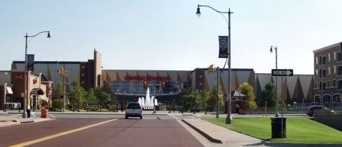
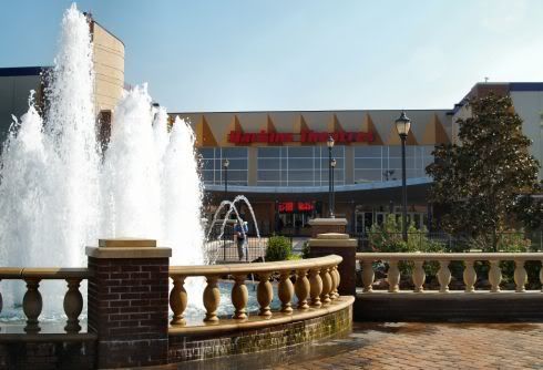
The Centennial Fountain Lies Immediately North of the Harkins
As Does the Bricktown Canal
In Front of the Harkins Looking Southeasterly

Walking North Toward the Centennial Fountain
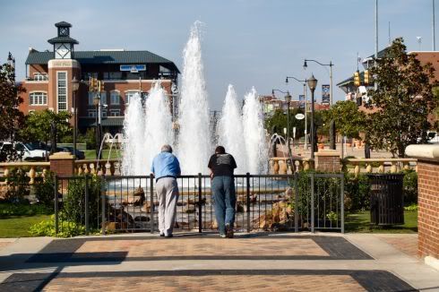
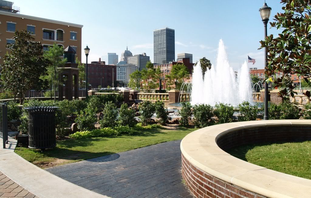
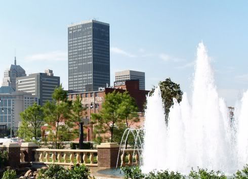
Looking Northwest From the Centennial Fountain

Zooming In Toward Downtown
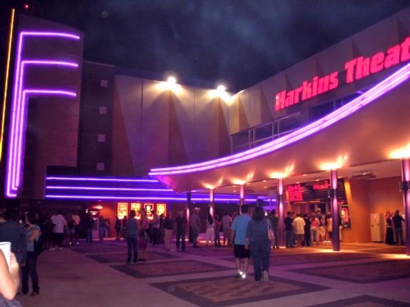
On a Hot August Night, August 2006

On September 26, 2007

So, once again, we can say, "Hey, let's go downtown to the movies!" and have a great place to go!
Top
... Click here to read the full article and any comments ...
|