
to include later information through June 24, 2010. Click here to jump to the June 24 update.
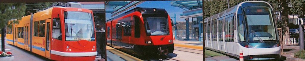
A series of 7 public meetings began on March 29 about the location of and other matters pertaining to the $130 million rail-based transit element of MAPS 3. During the campaign, we were told that the "transit package includes a five to six mile rail-based streetcar. The streetcar will link major employers, businesses, attractions and residents in the downtown area." Hosted by COTPA, the meetings (including yesterday's meetings) are on March 29 (2), April 13, April 29, May 11, and May 27 (2) and have the stated purpose of gaining the public's input on location and perhaps other related matters. Yesterday's meetings were in the City Council chambers, as will be the pair of meetings scheduled for May 27. The others are set to occur in the Civic Center's Hall of Mirrors, 201 North Walker.
All citizens have been invited to participate in these meetings and have also been given the opportunity to participate in an on-line surveys. The 1st survey, the subject being the possible location of the 5-6 mile route, is now done and was responded to by around 250. The results will be presented during the 2nd meeting on April 13. The 2nd survey seeks to identify users of the streetcar, ideal distance between stops and frequency of schedule, and is now in progress.
As another part of that process, five citizens have been asked and have agreed to contribute to the process by writing blog articles for these meetings, they being ...
 Charifa Smith |  Dean Schirf |  Nick Roberts |  Sam Sims |  Me |
Session 2, April 13 Session 3, April 29
Session 4, May 11 Session 5, May 27
The day after the 1st day meetings on March 29, Steve Lackmeyer wrote an article in the Oklahoman which gave his take on the presence of outsider bloggers reporting on the public meetings ...
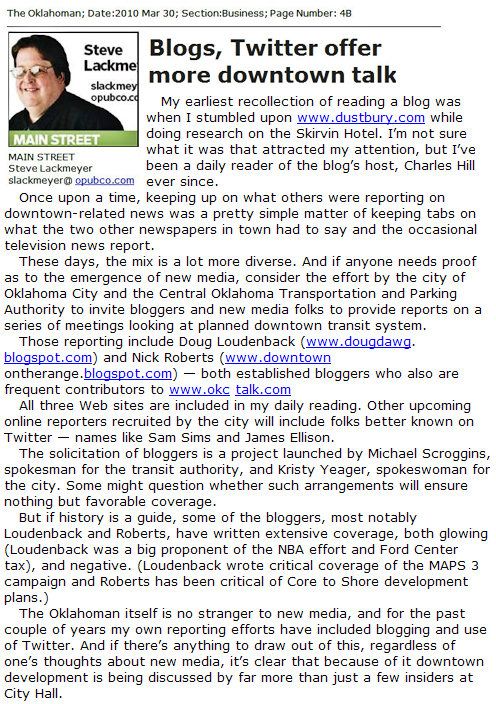
The solicitation of bloggers is a project launched by Michael Scroggins, spokesman for the transit authority, and Kristy Yeager, spokeswoman for the city. Some might question whether such arrangements will ensure nothing but favorable coverage.I hadn't been aware of how the guest bloggers came to be part of the process and that's good to know. As for my own blogging there, if actual discussion does occur in this process and the merits and demerits of alternate routes are seriously presented and publicly discussed, and remembering that "discussion" means "Consideration of a subject by a group; an earnest conversation," I'll be a happy blogger. If not, well, that's another story which will hopefully have no need to be written.
FIRST DAY SESSIONS. Two sessions were held on March 29, at 11:30 a.m. 6:00 p.m. and each lasted about an hour. You can watch each of those sessions below:
Noon Session | Evening Session |
I work with the Central Oklahoma Transportation and Parking Authority (COTPA). We are going to be hosting a series of public discussions to: (1) collect citizen input on where the modern streetcar should go in downtown Oklahoma City and (2) get public input on an Alternatives Analysis looking at other transportation options for the future of downtown Oklahoma City. We’ll gather citizen input through a series of public meetings beginning March 29 and through online forums, discussions and surveys.Her statement, “collect citizen input on where the modern streetcar should go,” caught both my attention and fancy and after speaking with her and agreeing to participate, she gave this definition of my and the other bloggers’ role here: Your role is to serve as a citizen reporter for those who can not attend the meetings. You should report on what happens at the meetings, what questions are being asked by the public and provide your own perspective. The March 29 Evening Public Meeting. The meeting was the second such meeting scheduled today, an earlier meeting having occurred in the City Council chambers at 200 N. Walker. Having time conflicts with its 11:30 a.m. - 1:00 p.m. schedule, I couldn’t make the earlier meeting. The evening meeting was scheduled for 6:00 - 7:30 p.m., and this piece reports on that although I assume that the 11:30 a.m. meeting was much the same. Uncharacteristically, I arrived well before the appointed time to begin and looked around to see who, if any, I knew. Jeff Bezdek, founding member and mover-and-shaker in the Modern Transit Project (I’m sure that he has a more appropriate title but I don’t know what it is) was there; one of my favorite Oklahoma legislators, now retired House member Debbie Blackburn, and friend Casey Cornett were, too, as was Michael Scroggins, Public Information Officer for COTPA, who’d earlier given Steve Lackmeyer and me a most excellent tour of Union Station. The evening meeting was not crowded so you might look over the 40 or so faces to see who you might know: The meeting convened shortly after 6:00 p.m. Jennifer Eve, moderator, introduced the three speakers: Rick Cain, director of COTPA; Mike McAnelly with Jacobs Engineering; and Project 180 engineer and coordinator Laura Story.
As it developed, the meeting was largely expository of the modern streetcar and its potential commercial and other benefits — the subject of possible downtown transit routes never came up at all. If you’d care to peruse the content of this website and compare them with what Cain and McAnelly had to say, I very much doubt that you’d find anything new being said. Of the main presentations, my sense is that McAnelly’s was the most informed and articulately presented although both were fine. That said, the types of topics developed were very fundamental, such as ... • What is the modern streetcar? • How does it work with other traffic? • How is the modern streetcar ADA compliant? • Who are current manufacturers of modern streetcars? • What cities presently and prospectively have them? • What about fares — some free, some not? I’m not developing these and other generic topics here because I don’t see what was presented as being particularly newsworthy and no breaking news was presented during the presentations. Questions from the audience were written upon forms and were then selectively presented to either Cain or McAnelly, and quite a number were presented (I wasn’t counting). That said, no voices were heard during the meeting other than those of Jennifer Eve, Rick Cain, Mike McAnelly, and Laura Story. I will elaborate more if comments request it after this post is done. But, as Bryan Dean said in his Oklahoman article about today’s meetings, “Monday’s meetings were mostly informational,” and he is accurate in that description. Read his report for more than I’m saying here. He doubtless attended the mid-day meeting. This meeting was scheduled to end at 7:30 p.m. but it adjourned at 7:00, lasting less than 60 minutes’ time. I was easily able to return home to eat some soup and tapioca pudding and settle in to watch my all-time favorite TV show at 8:00 p.m., 24, in which I was once again able to voyeuristically participate in Jack Bauer’s endeavors to save us all from hideous acts of international terrorism. Now, to be fair, there aren’t many, if any, that have the capability of topping my hero Jack Bauer in my interest level, and this meeting, while generally informative, gave me nothing new to chew on. Jack Bauer always does. Evaluation. It’s probably fair to give this first meeting a pass on public participation and a discussion of competing ideas, neither of which really occurred today. But since the meeting was apparently designed to be general and not specific in its scope but was merely an informative stage setter, that’s almost OK — except for the fact that we’ve been there and done that during the MAPS 3 campaign. As for me, only one such pass is OK. Future meetings need to provide a place for true public discussion — speakers and voices other than public officials actually need to be heard from the floor — and what about this concept: a meeting wherein ALL presenters would be non-public officials. Speaker 1 would advance and argue for Route #1; Speaker 2 would do the same for Route #2; and so on. If the Mayor or his proxy wants to present a route based on the “spoke system” he referred to during the MAPS 3 campaign, that would be great, too. That’s REAL public discussion. The submission of written questions which are then selectively advanced to a presenter by a question-screener may assure good order and avoid chaos, but that method does not allow for spontaneity and it does not provide for public discussion, not even close. “Discussion.” Look it up in your Webster’s. What we heard today was a general description of the modern streetcar. What we did not hear was a more fundamental description of why these 7 meetings were occurring or why they would matter when all is said and done. Window dressing we don’t want or need. What we do need is bona fide discussion, defined here to be “Consideration of a subject by a group; an earnest conversation.” Future meetings need to definitively define the process — what is the overall process for determining the downtown transit routes; how do these meetings relate to that process; and, if they don’t relate, then why bother? But, like I said, today’s meeting almost gets a pass. As a general information meeting, it was nicely presented, but I’m guessing that the 40 or so in attendance were already primed on the topic and were hoping for a bit more. |
That's it for now, but this article will be updated as each of the scheduled meetings occurs, and, hopefully, we'll see actual discussion and alternative routes seriously discussed before the process is done. I received an e-mail on April 9, part of which reads,
The next round of meetings, including the meeting on April 13, will be interactive, allowing participants to break into groups and offer input regarding possible routes.That is exactly the news that I've been hoping to hear.
Session 1, March 29 Session 3, April 29
Session 4, May 11 Session 5, May 27
| SESSION 2. As it developed, Session 2 lived up to the promise of public participation. The blog article that I've submitted to Let's Talk Transit has been published there and it also appears below. Also posted there are blog articles by Dean Schirf and by Nick Roberts but, frankly, you'll find (in my estimation) a more engaging article by Nick about this meeting in his own blog, here. | Session 2 full video, for as long as available at Wimeo.com |
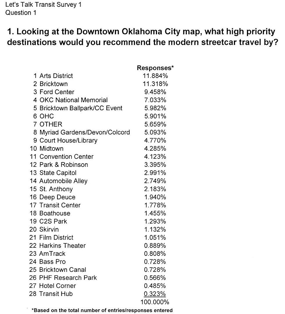
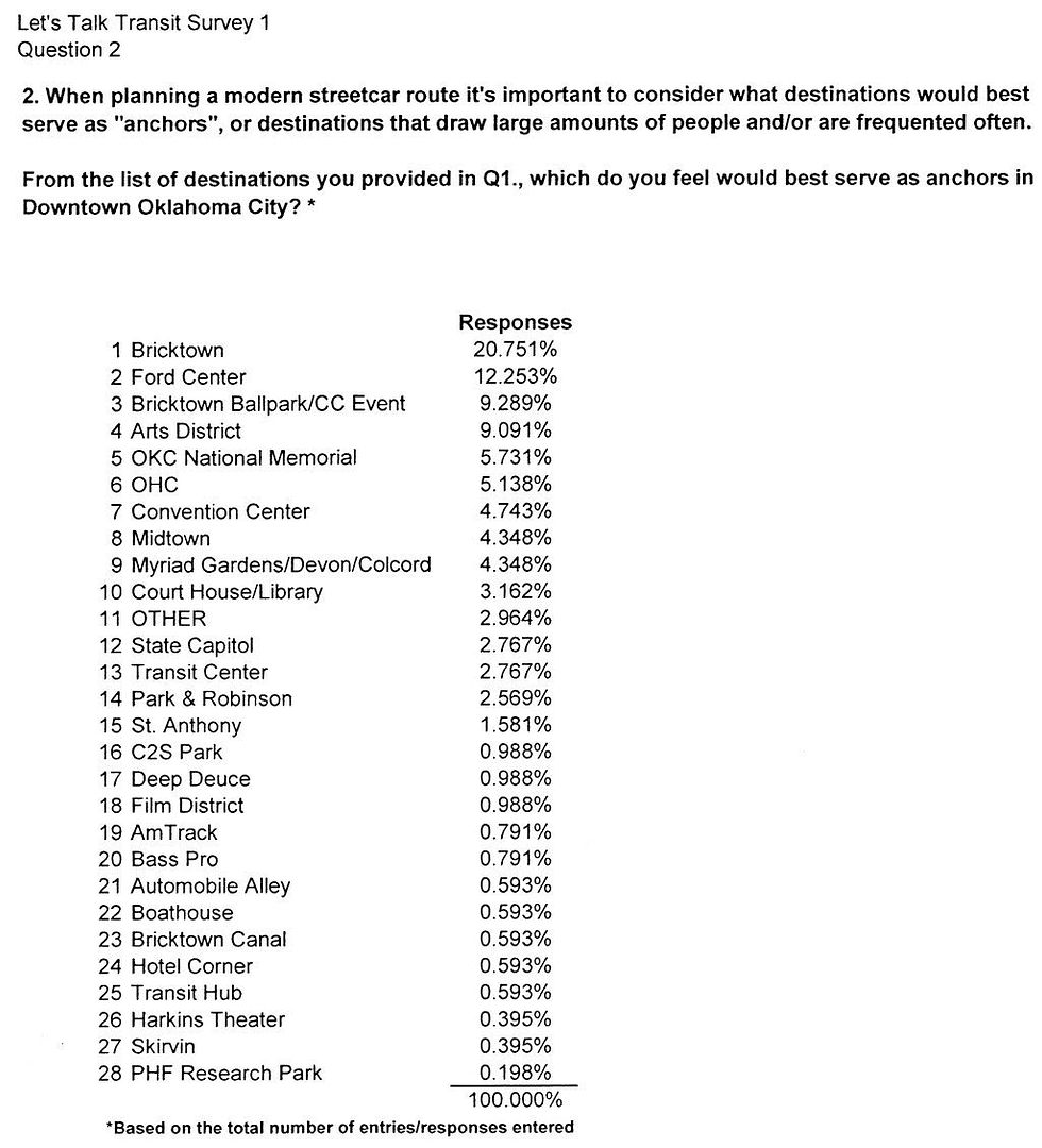
How To Design A Better Railroad The second Let's Talk Transit public meeting began shortly after 6:00 in the Civic Center Music Hall's Hall of Mirrors, a large open space meeting room on the 2nd floor. Unlike the 1st session (which ended sooner than the scheduled time), this session lasted longer than its planned 8:30 p.m. end, not adjourning until shortly after 9:00 p.m., probably because everyone was having so much fun ... either that, or the break-out working groups were just poky in getting their work done. I'll get to that shortly. Around 40-45 or so, including host personnel, were present. This session was intended to allow participants to play-pretend at designing possible routes for the 5-6 (or 2.5-3.0 or something in between) mile downtown transit route. I qualify the mileage length since it was made clear that the total lineal measurement depends upon whether either single or double-track is used during parts or all of the overall system. Single-track is one track shared by cars operating in either direction; double-track includes a separate track for each direction. If single-track construction is used, there need to be periodic passing sidings where a car traveling in one direction can wait while one going in the opposite direction passes. RESOURCES & MATERIALS. As did the 1st session, this one had a packet of materials for those attending. Some or all of these will probably find their way into the resource pages at Let's Talk Transit's website but I'll show most of them below. • Survey 1 Results. Let's Talk Transit is taking on-line surveys as one means of getting the public's input (click that link to see and/or take Survey 2, now in progress). Survey 1 (now closed) asked two questions:
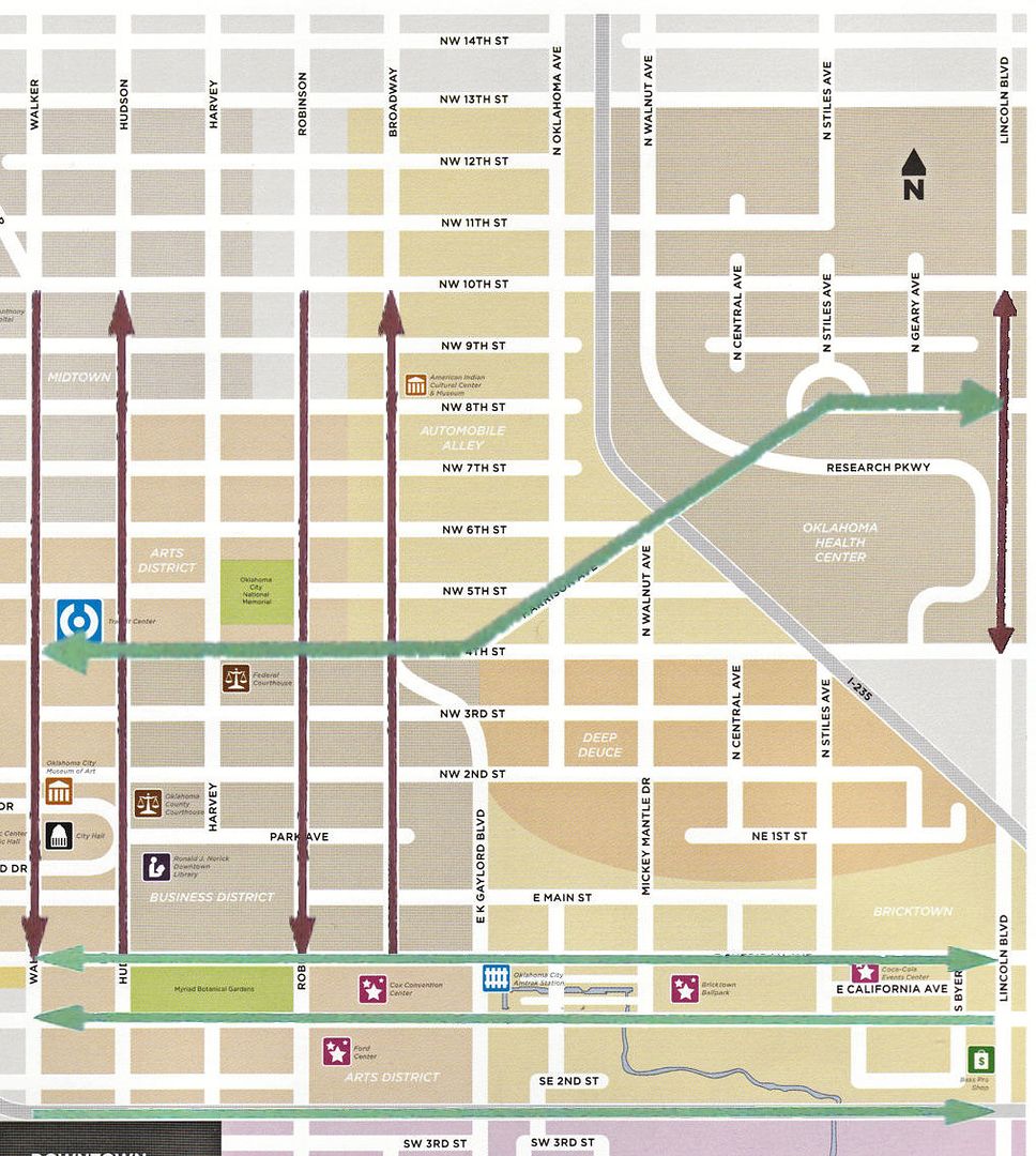
• Area Definition. The package included a general map showing the area being considered for the streetcars. Click the image for a larger view. 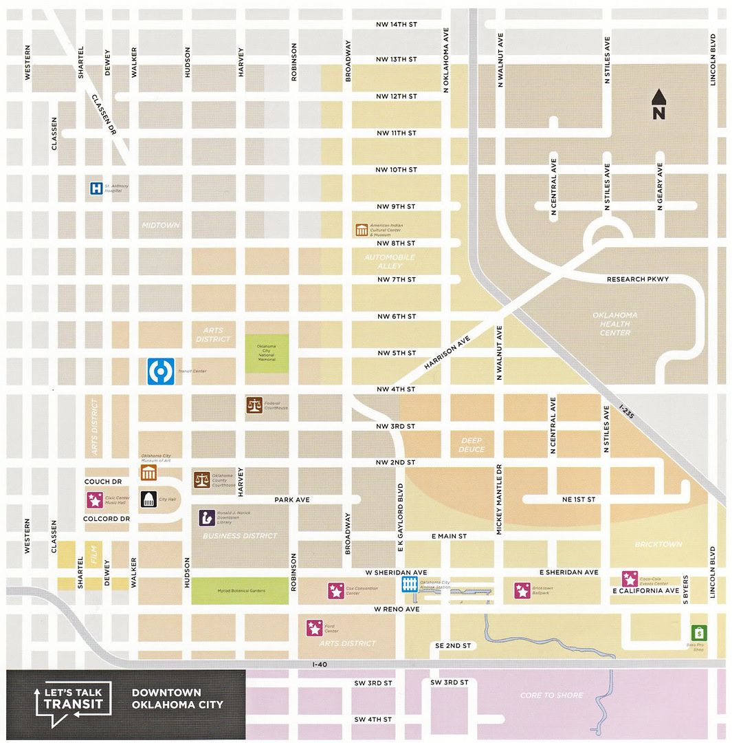 • Questions & Answers From 1st Session. During the 1st session, participants wrote questions on cards provided and most of them were verbally answered by one of the presenters. However, program staff did a great job of reducing all of the 38 questions and answers to written form, including those not gotten to in the 1st session. The names of both the person asking and answering are provided. My guess is that these will eventually appear in the Questions & Answers area of the Let's Talk Transit website, but that's just a guess. In the meantime, I've scanned the 4-page handout and you can read and/or save it here. THE MEETING. It took me a bit of time to locate the Hall of Mirrors, never having been there before. Basically, it is a ballroom sized room with some pretty deco decor with a small stage at the south end. The pair of images below shows some of what I observed ... click on images for larger views.
That's where Mike McAnelly of Jacobs Engineering (I'll call him the "Killer Bee" — this guy clearly knows his stuff) came in. By this point, if we (the wannabe rail-line-locater-experts) weren't already given more information than we could absorb in a time-span of 20 minutes or so, we would soon know how little we actually knew about the process of selecting of a preferred alignment of a rather limited (5-6 miles single-track, 2.5-3 miles double-tracked) downtown streetcar path. Now, I mean no slight to McAnelly by saying this — he never talked down to us and put stuff in street-speech that was easy to understand and what he said was most helpful. But ... but ... but ... in just a few minutes time we were going to assimilate everything we'd heard and then be let loose with maps and magic markers to come up with plans in the space of an hour or so's time? OK, OK, maybe I'm slower than most of the attendees — it's fair to say that's a given. I listened as McAnelly presented slides and described ... (1) streetcar guiding principles; (2) alignment considerations; (3) physical constraints; (4) patterns of economic development along "nodes" (I presume that means "stops"), varying depending upon whether (4a) single or (4b) double-track was employed; (5) peer city comparisons; and (6) a summary of technical methodology.  One thing he said that I'll pass along has to do with Bricktown. I recall hearing at the 1st session that the street underpasses under the Santa Fe tracks have less clearance than most streetcars require ... "How is that going to be solved," I wondered, "we sure as heck cannot change the elevation of the Santa Fe track." But McAnelly made it sound so simple ... lower the bed for the streetcar, i.e., make the road go "down!" I made a note to slap myself on the back of my head when no one was looking. One thing he said that I'll pass along has to do with Bricktown. I recall hearing at the 1st session that the street underpasses under the Santa Fe tracks have less clearance than most streetcars require ... "How is that going to be solved," I wondered, "we sure as heck cannot change the elevation of the Santa Fe track." But McAnelly made it sound so simple ... lower the bed for the streetcar, i.e., make the road go "down!" I made a note to slap myself on the back of my head when no one was looking.
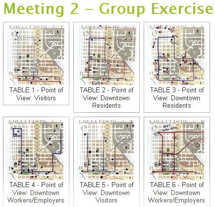
McAnelly's last slide summarized the "Technical Methodology" for finally arriving at selection of a preferred alignment:
Youza! After hearing all these guys, for those of us who weren't experts at 5:59 p.m., we surely must be experts by now! At this point, the meeting broke into working groups. Each working group had a particular element to focus upon, e.g., residential or some other category. The goal of each group was to arrive at and then present to the group one or more alternatives within its assigned category, and this is where the fun began. WORKING GROUPS. Armed with all of the above, participants broke into six working groups. Some were assigned one type of consideration (e.g., residential) or another. Each group had a moderator — for example, mine was Randy Entz with the city planning department — but the moderators were there to keep the rest of us on track and not to make route suggestions. At one point, I said to Randy, "You guys have surely come up with your own models. Can you give us a clue?" He said, "Yes," but declined to reveal planning department ideas, saying (to the effect), "that's not what these sessions are about." I asked him, "Have you ever seen a hub-spoke model like Mayor Cornett said he preferred during the MAPS 3 campaign," and he said, "No." The following pictures show the working groups as they came up with the routes which related to their assigned categories. Click on an image for a larger view.
EVALUATION. One cannot but be seriously impressed with the amount of time, work, and money that city personnel put into making this a successful meeting — everything from handouts to presentations to organization of the working groups was exceptionally well thought through and executed. For example, at each table, large demographic maps were present to use as resources to identify where people worked and resided and how many, location of hotels, etc. One such demographic map is shown below. Click for a larger image. 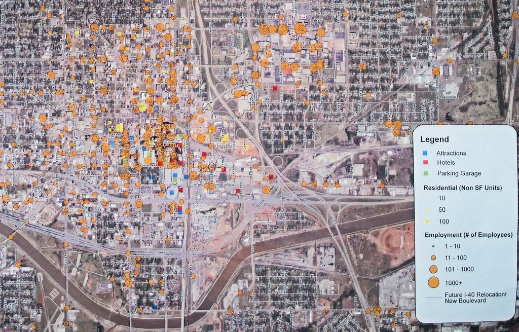 Plus, it was great to meet and talk with others who are interested in this process and want it to succeed. The promised public participation was abundantly present in Session 2. Postscript. One of my table's participants, Walter Jenny, and I were talking and he mentioned something about the location of the old Oklahoma Railway Co. lines in downtown — wouldn't that be good to see? He was absolutely correct. So, here you are, a crop of the trolley map from When Oklahoma Took the Trolley by Allison Chandler and Stephen D. Maguire (Interurbans 1980). I've included the area north of 13th Street up to 23rd, to give a better idea of that area, too. Click on the image for a larger view. 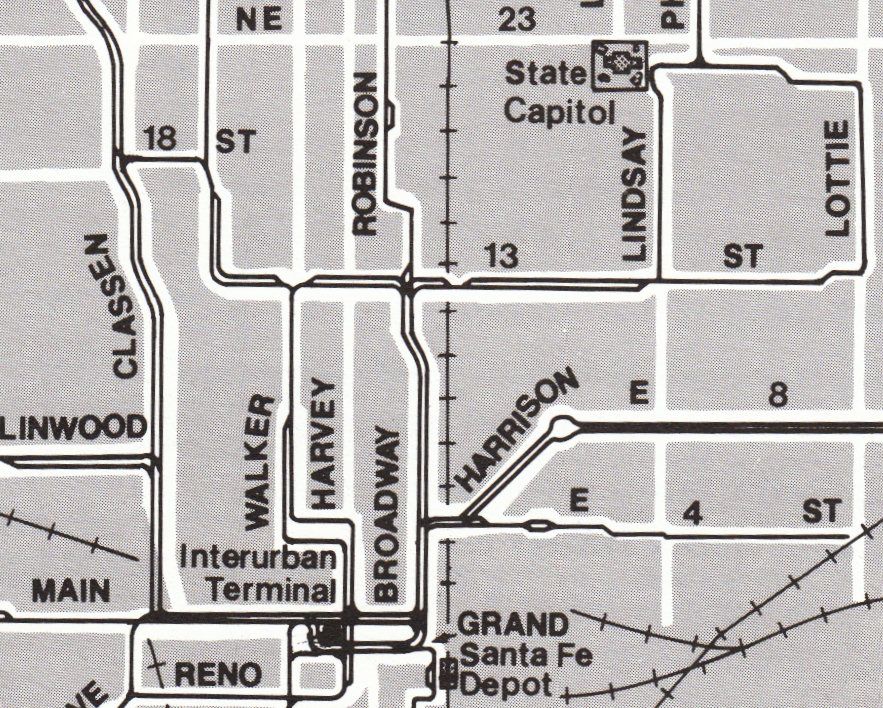 | |||||||||||||||||||||||||||||||||||||||||||||||||||||||||
Session 1, March 29 Session 2, April 13
Session 4, May 11 Session 5, May 27
| SESSION 3. I wasn't a scheduled blogger for this event but I already planned to go and write in my personal blog, anyway, just as I have done for the earlier meetings. As it happened, time conflicts developed for the two intended bloggers, Dean Schirf and Sam Sims. So, unfortunately — and I say that with no disrespect to myself ... it's just that different eyes will see events differently and have different perspectives and it's good to get a blend — the only "outsider" report you get for Session 3 is from me. The article I've submitted to Let's Talk Transit appears below. | Above, the session's full video for as long as it remains available at Wimeo.com |
Wax On ... Wax Off Session 2 might be akin to the beginning of Daniel-san's learning curve presented by Mister Miyagi in the Karate Kid. As it developed, the 3rd session was another step along the same path, "Brush up, brush down," except that the brush-stroke also went from side to side, from east to west as well as up and down, from north to south. Before attending the meeting, I scoured the Let's Talk Transit website to see what this new session would be about ... heck, maybe I would even do a little homework to be better prepared. All I could locate was the date, time, and place of the meeting which, of course, required no homework at all. Just be there. Anyway, camera in hand, I got there about 20 minutes before the meeting began at the same place as the last meeting so I'll show no new pictures of the Civic Center Music Hall's Hall of Mirrors (but you can see a few of those in my article on Session #2). On arriving I signed in, slapped on a name tag, and looked for a packet of materials similar to that given in the 2nd session. No, no packet this time ... just an agenda with an image on its backside which wasn't (as far as I could tell) in any way relevant to this evening's session. The backside image is an overlay of the possible routes garnered from session #2, showing similarities and dissimilarities. However, each of the 6 groups had different purposes, e.g., residential, commercial, etc., so the image proved not to show anything particularly useful in the context of this evening's meeting.I looked over this evening's agenda with great anticipation ... have a look: "Yo! Adrian! What's this meeting going to cover," I asked the sign-er-in-ers? They didn't know, either. Like the last session, we were all sitting at tables with various charts and maps and markers, so we knew it would be another working session. SURVEY 2 RESULTS. Before that began, Rick Cain described results of Let's Talk Transit's on-line survey #2. Unless I missed it, no one said how many survey responses had been received as of the time the results below were assembled. In case the link just made eventually does not work (as it might not if the link comes to be a different survey), the links below will still work.
Here were the options presented (click on either for greater detail). Routes (or portions thereof) having arrow points in each direction are double-track routes; the others are single.
But I do have two suggestions:
The point is: given all of the dynamics present, 40 minutes ain't nearly enough time to learn how to whooping-crane-drop-kick a jerk like the Karate Kid did at the end of the movie. Much more thoughtful contributions would be possible in such a short span of time if some or all had already done the, "Wax on, right hand. Wax off, left hand. Wax on, wax off. Breathe in through nose, out the mouth. Wax on, wax off. Don't forget to breathe, very important," and then learned the "paint up, paint down" routines. A last item has not left my consciousness since the very beginning — how, if at all, are these nicely presented sessions going to impact the ultimate decisions? Are we who are attending just enjoying a nice parlor game or does it have more meaning than that? No one has really addressed that. It was very evident from tonight's session that city planners and COPTA have given much thought to potential north/south and east/west routes, as one would hope and expect that they would. The fact that the various options were presented was a great aid in this evening's meeting. While I'm one who was glad that that was so, one is nonetheless left to wonder, "In what way, if at all, was Session 2 (or 3) significant in the overall process, other than to provide evidence of public participation? Will any existing planner thoughts be changed by reason of anything that occurred during the course of this process?" Don't get me wrong — I'm enjoying this exercise and will finish it out to its end. But, I can handle the truth whether it be that these sessions are just for fun or whether they just might mean something more. Perhaps someone will yet address those questions, not yet done, at least not to my satisfaction, before the process draws to a close. | ||||||||||||||||||||||||||||

Session 1, March 29 Session 2, April 13
Session 3, April 29 Session 5, May 27
SESSION 4, May 11. Although I was initially present for this session the Civic Center Hall of Mirrors, I began to feel poorly and didn't stay. So, I have no first-hand report of this meeting. However, the Let's Talk Transit Meeting Summary is available for your reading, as is Dean Shirf's Blog Article and Nick Robert's Blog Article and I defer and refer you to those articles for further information.
Session 1, March 29 Session 2, April 13
Session 3, April 29 Session 4, May 11
SESSION 5. This session had two public meetings today in the City Council chambers, a noon meeting beginning at 11:30 am and the session which I attended at 6:00 pm. The purpose of these meetings was to sort of wrap up what had previously occurred, present three models which were said to result from the previous meetings, and have an extensive question and answer session after all that was done.
Personally, the main item I was looking for was an answer to my lingering concern and that which I have stated from the beginning — are these meetings really being conducted for the purpose of obtaining and actually utilizing public input as to the location of the streetcar routes, or have they been something more akin to parlor games where the participants get the opportunity of fashioning models, have a good time, but the activity and results of the exercise have little if any meaning beyond those who participated. I am glad to say that, before this meeting was done, my sense became this: Yes, at least as far as the hosts of these meetings is concerned, the input received has influenced the proposed placements of the street car routes. I'll elaborate more about that in the Evaluation section of the blog article which I have submitted to Let's Talk Transit for publication there which it has been, that full article appearing below.
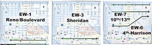
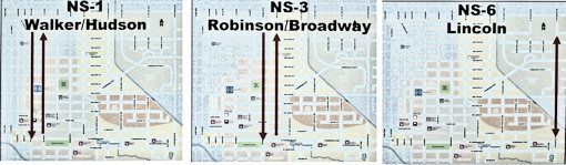
What's It All About, Alphie? The concluding sessions of the Let's Talk Transit public meetings occurred twice today in the City Council Chambers — a noonish session beginning at 11:30 am and an evening session beginning at 6:00 pm which is the session that I attended. I didn't take a head count but I'd suppose that 30-35 people were present, including staff and the presenters. You can see for yourself that the meeting was not elbow-to-elbow, but the attendance was not out of keeping from the earlier sessions, even if down from the number attending the working-group sessions. Click on most images in this article for larger views. 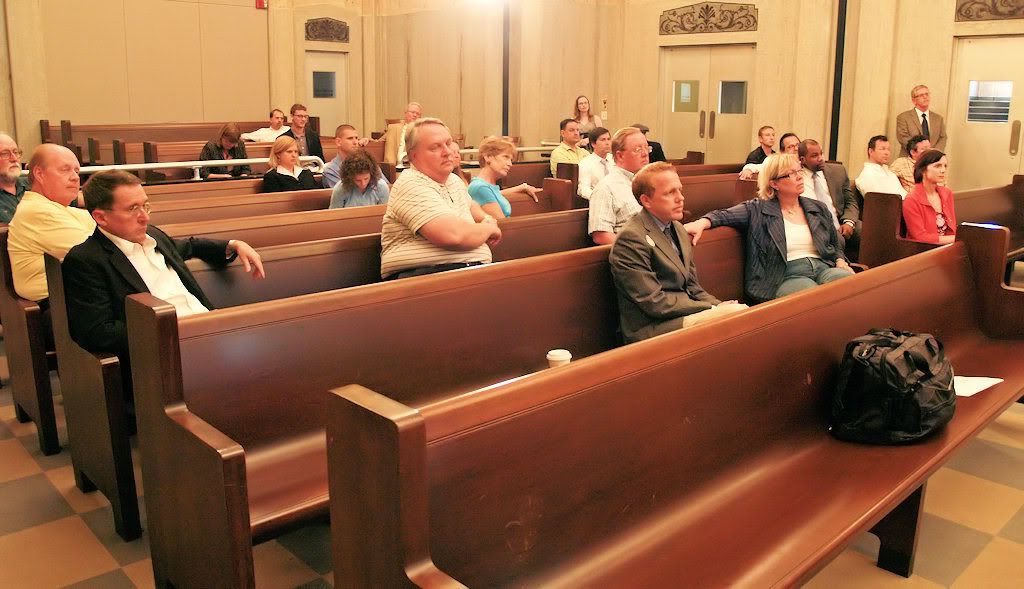 The first part of the meeting consisted of recaps of the previous meetings presented by Rick Cain, director of COTPA and Mike McAnelly with Jacobs Engineering of Dallas (and, as always, Jennifer Eve was the effervescent master of ceremonies). That said, nothing new was presented during this part ... it was just a recapitulation of what had been done and said before. McAnelly then reviewed the three models submitted for discussion in this session. He described them with reservation — that they were by no means set in stone. More, when he described how these models derived from previous sessions, he postured them as being models which were designed to produce and provoke discussion. He took care to say that these models were not necessarily those which would be later be presented to the MAPS 3 Oversight Board — at least, not in the sense of being "preferred routes" resulting from the Let's Talk Transit process. I'll say more about this in the Analysis section, below. 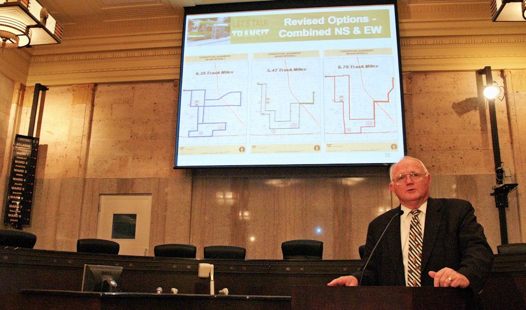 The three options were presented thusly (click on images for a larger view):
 Let's Talk Transit assembled a composite map shown at session #3, shown below. 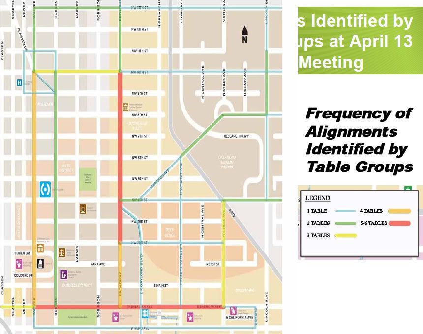 Notice that 4 of the 6 (that's 66%) arrived at drawings showing Walker as a preferred route regardless of the streetcar user group they were charged with representing (visitors, residents, workers). But, notice, also, that Walker was not included as a preferred route in any of the three proforma options presented at today's meeting. I'll get back to that point in the Analysis section below. After Mr. McAnelly's presentation, a lengthy question and answer session followed. In fact, the meeting which was scheduled to end at 7:30 did not adjourn until at or shortly after 8 pm. Most questioners followed the ground rules and wrote their questions on the forms presented — some others didn't and merely raised their hands and had their questions fielded on-the-fly. The meeting handlers weren't all that great about handling the flow of questions since some, who followed the rules, probably didn't get their questions answered because of the line-cutter-inners which were permitted to co-opt their legitimate place in line. Not a biggie, but it was nonetheless an irritant to me — if rules are established, damn it, follow them, and don't let others who didn't do so effectively cut in line with their non-form questions receiving priority attention. 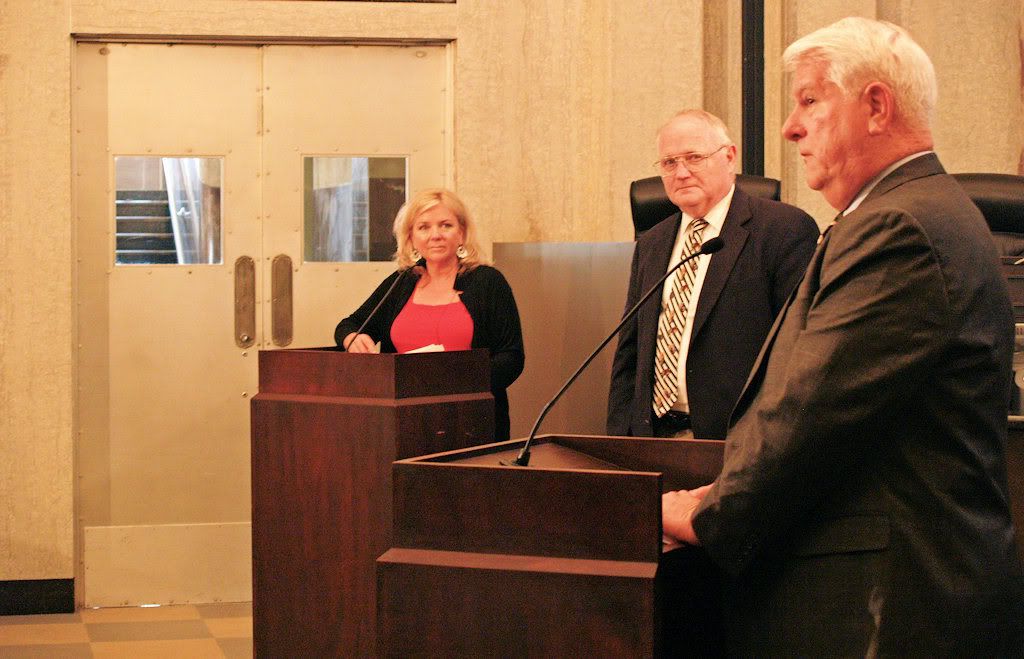 I didn't make notes as all these questions and answers were being presented, partly because I was aware that ALL written questions would be addressed shortly in the Questions & Answers part of Let's Talk Transit website, just as they have before. The questions were plentiful and, I thought, they were answered straightforwardly during this session. When the Q & A is published at the Let's Talk Transit website, I'll include a link to them here. The Q & A session was substantial enough that the planned 7:30 p.m. end of meeting did not occur until about 30 minutes later and even then the presenters hung around to answer additional questions from any who wanted to ask, me included. ANALYSIS. Since this was the final Let's Talk Transit public meeting, my analysis focuses on two items in terms of recap: (1) Did the Let's Talk Transit people do a good job? (2) Were my concerns about the meaningfulness of these sessions addressed, and, if so, how and why?
When top city leaders give cause for distrust, it has a spillover, a trickle-down, effect, at least it did for me. And so it was that, when the Let's Talk Transit process began, I wondered out loud in my columns here whether the promised public input really mattered or whether it was merely window trimming for matters already decided or which would come to be decided regardless of public input. In this context, although I'd experienced excellent meetings during the Let's Talk Transit process, I continued to wonder if all of fine public participation really mattered. Part of that wonder had to do with the route scenarios presented at this meeting. Notice the omission of Walker in any of the three proforma route scenarios, shown above. If 4 of the 6 working groups indicated such a preference, and if public input really mattered, why was it not included in at least one of the presented possibilities? To answer that question, let me digress a bit. I arrived at the meeting early and had an opportunity to chat with with Messrs. Mike McAnelly, Rick Cain, and Michael Scroggins. I mentioned to Michael that, if he'd read what I've previously written he might have noticed that an underlying concern I had was whether the public input gathered from the Let's Talk Transit process would really matter when routes were finally determined, and that I was hoping to hear something in this last meeting that would allay my concern. His good-natured reply was, to the effect, "Well, if the meetings don't take public input into account in arriving at routes, we've (he and COTPA's staff) surely have been wasting a lot of time," but, of course, that answer begs the question. Without any doubt, COTPA and its staff, as well as those in the city planning department, have expended lots of time and money putting these excellent sessions together. But, the question remained, "to what end?" My distrust was soothed a bit during McAnelly's presentation. He made it clear that everything presented during the sessions would be presented to the Oversight Committee, the next step in the process, including the routes submitted by all groups, including that a 2/3 majority of those favored that Walker be included. But, the question lingered, why hadn't Walker included in the proforma scenarios? After the meeting, a final opportunity to talk with him occurred. After Steve Lackmeyer asked McAnelly several questions, I got my turn. I had written my question on one of those cards that didn't have time to get answered (thanks to those who circumvented the written question approach), and here was my chance, face to face. I've forgotten how the written question was literally worded, but the gist, and my oral question, and the rest of the conversation, came out something like this: Loudenback: We are told that public input is helping shape the placement of the streetcar routes. Given that, can you give one example of a route that would most probably NOT have been included but which was as a result of the public sessions? I understand that this is sort of a convoluted question, but do you get my drift? I guess that I'm saying, "Prove it."Without-a-blink straightforward honesty and integrity will win me over anytime, anyplace. With that, my concerns, above expressed, were dashed, and I am exceptionally pleased to say that I have no lingering doubts about Let's Talk Transit's stated intentions as being true. Trust is an earned thing, and, in Let's Talk Transit, I am satisfied that the trust is deserved. My final comment and additional hope: Perhaps the good will engendered by Let's Talk Transit will have a trickle-up effect, as well. |


Session 5 Postscript: Some at OkcTalk.com are questioning whether I've been too generous in giving a pass to Let's Talk Transit's sincerity in being devoted to giving public input to the location of streetcar lines downtown. There, Larry OKC says,
I appreciate your analysis but one question remains. If they used the meetings and the routes generated from those meetings, how in the blazes did they overlook or make a mistake and leave Walker out? Especially when it was chosen by 2/3 of the participants. I am afraid that I can't share your optimism on this. How do you know that "a majority favor Walker will be shown as a public preference"? How prominently will this be emphasized? Are they going to redo the maps reflecting Walker or is that going to be a throw away line buried in the report? As you said trust is earned and so far I think the jury is still out on this one.And Steve Lackmeyer adds,
Here's the problem with consultants: no matter how smart, honest or good they may be, they still must compile what their employer wants. And that's where I'm skeptical. I don't buy that ignoring the preference for Walker was an "oops." Route maps aren't assembled like that. There was a conscious decision to ignore Walker, and I've got to still question whether McAnelly was being totally upfront in his explanation as to how that happened.To get clarification on the matter, I've left this comment to my own blog article at the Let's Talk Transit website:
I've seen behind-the-scenes efforts by elected leaders and city staff to sway consultants' reports time and time again over the past 15 years. I've seen some consultants' reports killed all together (oh say, has anyone seen the Bricktown land use plan yet? How about the office marketing study commissioned four years ago by Downtown Oklahoma City Inc.?).
And there are people who feel that the Core to Shore plan was outright corrupted for political means.
So you've got to ask yourself this: what do you believe? Do you believe McAnelly and his crew did an "oops," are sloppy and either couldn't read survey responses right? Do you believe they traced the wrong line?
OR... do you believe there was a conscious decision made to ignore the Walker preference? And if so, shouldn't he explain more as to why rather than just say "my bad"?
I'll add my own comment:All I'm looking for and wanting to do here is present is the truth. So, if my gut reaction when speaking with McAnelly was mistakenly taken for the truth, I stand, and want to be, corrected. Why not post your own queries or comments at at the end of my blog article at Let's Talk Transit and perhaps Let's Talk Transit people will respond and get the matter clarified, once and for all.
After reaching the conclusion that I did following my conversation with Mike McAnelly (reported immediately above), some at OkcTalk.com remain skeptical that the omission of not including Walker on one of the 3 proforma scenarios was a mistake in one of two senses: (1) Merely an "oops" mistake, meaning that it really was intended to be included but because of inadvertence was not; or (2) a mistake for not including Walker given that 2/3 of the table participants in Session #2 thought it should be include, given that the stated aim is to represent public input.
It would do no harm, and would likely do some good, for someone from Let's Talk Transit to directly address the Walker omission from the 3 proformas, and I encourage that response, either in a comment here or in some other place in the Let's Talk Transit website.
Another side of the coin is this: If Let's Talk Transit DOES NOT present Walker as a public-preferred route-of-choice to the MAPS3 oversight committee, my "gut" reaction will be obviously have been proven to be erroneous, and all of what I've said above about believing that Let's Talk Transit was sincere in obtaining and putting forward public input will have been badly mistaken. I still hope, and trust, that is not the case.
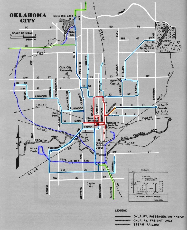
Incidentally, for those of you wanting to know more of Oklahoma City's trolley legacy, you might enjoy reading Trolleys Part I which covers the early days of trolleys in the city. I've not gotten around to doing Trolleys Part 2 which will cover, if and whenever it's done, the period of roughly 1911 until trolleys and interurbans ended here in 1947. Included in that article is the map below showing the city's earlier trolley and interurban routes ... click on the image for a larger view.
Allison Chandler and Stephen D. Maquire (Interurbans 1980)
Color codes: Red=original tracks, Light Blue=later passenger
or freight, Purple=freight only, Green=interurban
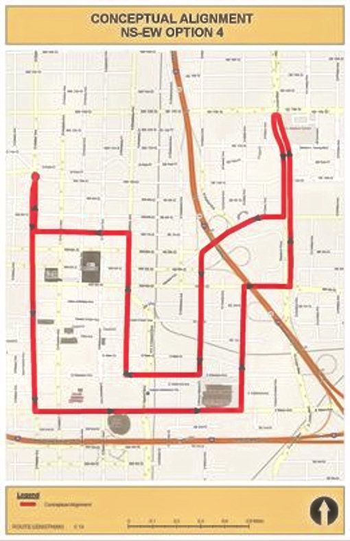
JUNE 24, 2010 UPDATE. Let's Talk Transit has now added a 4th Option, supplementing the others presented at the May 27 meeting -- a possible Walker route.
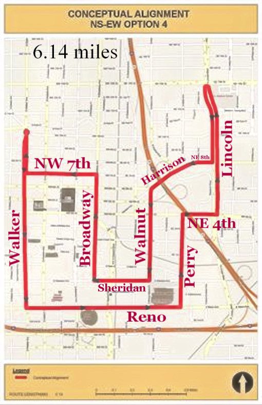
... with my editing to show streets and mileage ...
On June 24, 2010, at Comment 7 to my last blog post there,
Mike McAnelly wrote:Mike McAnelly is a man of his word.
We appreciate your giving five stars and positive comments for the Let's Talk Transit process. COTPA designed the process to obtain input from stakeholders and the public, and we consider it to be very effective thus far.
An additional alignment option that features a north-south alignment on Walker and Broadway, forming a “big loop” alignment, was discussed in the May 27 meeting. Recognizing that input, a new Option 4 map has been posted on the LTT website at: http://www.letstalktransit.com/meetings.
This option totals 6.14 track miles. In addition to the Walker-Broadway loop, it includes linkages with St. Anthony Hospital, Bricktown, Deep Deuce, and the OU Health Sciences Center.
As further analysis is reported to the Steering Committee, additional alignment options will be posted on the Let's Talk Transit website for public review. Upcoming public meetings will be announced and conducted as COTPA continues the Downtown Circulator Alternatives Analysis. Public input received will be presented to the AA Steering Committee, as they consider recommending a preferred streetcar alignment to the MAPS Oversight Committee. Citizen input and technical analysis will shape the selection of the locally preferred alternative. The Mayor and City Council will ultimately be the community’s decision makers.


