Was a convention hotel mentioned as a part of the MAPS 3 campaign? Part of the June 11, 2013, City Council discussion focused on that question during a presentation by the Alliance for Oklahoma City Economic Development. A truncated version of the discussion, focusing only on this question, appears below ...
For a few dollars more.
MORE THAN WHAT?That would be more than the $280 million (now $250 million) that those in charge of the MAPS 3 campaign said that it would cost to fund the convention center element of MAPS 3 ... around $50-$250 million dollars more ... that the city would need to spend for the MAPS 3 convention center project for it to be economically viable. In this context, "city", unfortunately, means the taxpayers of Oklahoma City. You can be sure that the mayor and city council members, as individuals, aren't going to pony up the cost of financing a convention center hotel, right?
The above video only contains relevant portions of the council meeting as to whether a convention hotel was mentioned during the MAPS 3 campaign. The complete discussion between Ms. O'Connor and the City Council is in the 22:43 minute clip below. The main components of the discussion begin at the following time-points ... use the slider to move to particular locations ...
BACKGROUND. In this period, it is helpful to understand that a convention center AND a convention hotel were not always linked together as they have evidently come to be linked today. I'll begin with the easiest part, the development of the city's downtown hoteliers.
A Glimpse At Downtown Hotel History. This by no means traces the history of Oklahoma City's downtown hotels and is only a peek at a part of it. Building and operating hotels involves a good bit of risk taking, and Oklahoma City's downtown hotel experience is abundantly steeped in both sides of that flipped coin, particularly concerning the frailty of downtown hotels when economic times are tough and public assistance in helping them survive was non-existent.
The Biltmore. Construction of a large downtown hotel finds a precedent with the Biltmore. With construction starts and stops before it was completed, the Biltmore was constructed between 1929 and 1932, it opening in March during that year, a year after the Great Depression finally hit Oklahoma City. It involved a monumental undertaking for private business leaders to get the project completed. A number of city capitalists played key roles in making this hotel a reality, including Charles F. Colcord, Martin Reinhart, Stanley Draper, J.F. Owen, Frank Buttram, Frank P. Johnson, W.E. Hightower, W.T. Hales, and W. R. Ramsey who built the 33-story Ramsey Tower (now City Place).
About Johnson, it was said in a December 18, 1931, Oklahoman article on 1931's "Most Useful Citizen," that:
In nominating Johnson, C. Edgar Honnold, broker, wrote: * * * I believe it has been through his efforts that the First National building has been erected. It is certainly a great credit to any community, institution or individual. I believe it has been mostly through Mr. Johnson's efforts that the Biltmore hotel has actually been constructed and completed. ¶ Charles W. Gunter, chairman of the First National bank and Trust Co. executive committee, and W.R. Ramsey, oil man, also nominated Johnson for similar reasons. ¶ Gunter wrote: "I am convinced the Oklahoma Biltmore never would have been built had it not been for his (Johnson's) untiring efforts and leadership."
In a December 25, 1931, letter to the Oklahoman editor, J. K. Wells nominated Ramsey, noting, among other things,
He was largely responsible for bringing the Biltmore hotel to Oklahoma City and was the first to suggest the idea to the Biltmore interests of New York City.
As to Colcord, a March 6, 1932, Oklahoman reporter T.T. Johnson said,
Seventy-two years old, he is still straight and agile. His brown eyes are clear, his hair snow-white. He has proved his generosity and kindliness many times, and his record forbids that anyone ever should gainsay his qualifications as a forceful leader. During the three-year fight for the Biltmore, he arose early and worked late and vigorously. When the hotel seemed doomed, he snatched it from the brink of failure. He drove, drove, drove, into the pocket books of men who were able to pay. He has given Oklahoma City, Oklahoma and the southwest its finest hotel.
The project also involved a community effort. As late as early 1932, money was still needed for an operating fund for the hotel. In February 1932, stock sales were solicited from the public to create a $400,000 operating fund for the hotel.
When done, standing at 26 stories plus two basement levels, it was the 3rd tallest downtown building (although it claimed to be the tallest, perhaps because of its signage) and hosted 619 rooms. The Biltmore was then the largest hotel in the state and was said to be "the finest hotel in the Southwest." From 1932 until its destruction in 1977, no Oklahoma City hotel has matched its size or room capacity, and none have thereafter. To this day, the Biltmore remains as a shining example of what Oklahoma City's business leaders can do if they are willing to take the risk, even if dire economic challenges are presented while doing so.
In retrospect, what would Charles Colcord do today? One can but wonder what Charles F. Colcord might do if presented with today's challenge of building a convention hotel in Oklahoma City. Would he enlist investment by Oklahoma City's existing capitalists and take on the job of making it happen? Would he engage experts to determine the need? Would he involve the Alliance for Economic Development? Would he ask city taxpayers to share in the expense? Or would he just step up and see that it got done, just like he did with the Biltmore? These days, are any capitalist leaders around in the mold of Charles Colcord, whether he/she be a member of the Chamber or not?
Urban Renewal Hotel Destruction. Beyond the Biltmore, many of us remember the stark time that the Urban Renewal Authority demolished many downtown hotels in the 1960s-1970s, including the Huckins, Bristol/Threadgill, Kingkade, Egbert, Oklahoma Club/Tivoli Inn, Wells-Roberts, YWCA, and others, including, to be sure, the Biltmore.
Urban Renewal Aftermath. After those legacies were gone and the 1964-1993 Holiday Inn (last named the Commonwealth) at 520 W. Main closed its doors as a hotel, only the 1976 Sheraton Hotel (then called the Century Center) remained as a downtown hotel. In 1993 it, too, was in dire straits, it owing $167,000 in back property taxes for 1990, 1991 and 1992. As for the Skirvin, it closed its doors in 1988, not to be reopened as the Skirvin Hilton until 2007, 19 years later, and only after a huge effort by the city and private partners was the Skirvin restored to its former glory in 2007.
The City's Existing Downtown Hotel Stock. As described above, Oklahoma City's downtown hotel status had been abysmal for many years prior to the 2009 MAPS 3 election, even though it had improved by that time. At one point, after the former Holiday Inn (via various iterations) (about 200 rooms, 1964) finally closed as a hotel in 1993, Oklahoma City's downtown included only one hotel, the Sheraton, built in 1977, with 395 rooms. Hotels either completed or in construction as of July 2013 are shown below.
Between 2000 and 2008, six (6) hotels were added: the Marriott Renaissance (2000, 311 rooms); the Courtyard Marriott (2004, 225 rooms); the Colcord (2006, 108 rooms); and, not the least, the Skirvin Hilton (2007, 225 rooms). In Bricktown, the Hampton Inn (2006, 200 rooms) and Marriott Residence Inn (2006, 151 rooms), were also added.
As of this writing in July 2013, four other hotels in Bricktown, Deep Deuce, and/or the Health Sciences area, are under construction and will open in 2013 or 2014: Hilton Inn & Homewood Suites (2013, 255 rooms); Aloft (2013, 130 suites); Holiday Inn Express (2014, 124 rooms); and Embassy Suites (2014, 194 rooms).
Yet another, a 54-room Midtown boutique hotel owned and being developed by Tulsa hotelier Paul Coury's company (which developed the Colcord Hotel in 2006) should be included. This outstanding project is presently converting the historic 1929 Osler physicians building at 1200 N. Walker into an Ambassador Hotel and it is scheduled for opening in December 2013. That date may be a bit ambitious — I'm guessing that an early 2014 opening is more likely.
Still other downtown hotels are in the proposal/approval stage, but I'm not including any of those projects in hotel room count here since doing so would involve some degree of speculation, and that includes a possible convention center hotel. Others not included are possible hotels that have been mentioned but remain speculative: Staybridge Suites (Bricktown, 131); East Bricktown (Bricktown, 150); Springhill Suites (Deep Deuce, 125); Patel's 2 potential projects in Bricktown at Lincoln & Sheridan (125 each).
As it stands today, the downtown stock of hotels, either built or being built, numbers twelve (12) and, unless I've misread something, that amounts to 2,372 downtown hotel rooms or suites which could bear some or a lot of risk should the city decide to finance, partially or completely, a convention hotel — which would compete against them — and remembering that "economic times" are historically cyclical and include both good times and bad.
Several articles by Oklahoman reporter Steve Lackmeyer have documented downtown hotel development. In his December 6, 2005, article, Lackmeyer reported on the appointment of Alan Sims as the convention center sales director. Lackmeyer said, "A decade ago, the Interstate 40/Meridian Avenue hotel corridor dominated the convention business. Since then, the downtown hotel market has recovered, with the number of hotels increasing from just one, the Sheraton, to seven with 1,400 rooms being opened over the next two years."
The Chamber's Pre-Maps 3 Point of View. Well before the 2009 MAPS 3 campaign and after several downtown hotels had been added (above), the Greater Oklahoma City Chamber of Commerce had been pushing for a new convention center, AND a new convention center hotel, although not always in tandem. In the December 2005 article referenced above, Lackmeyer said that, "[new convention sales director Alan] Sims said he thinks the city's Metropolitan Area Projects improvements downtown and at the State Fair Park, combined with new hotels, make the city ripe for a move into the second tier of the convention market. He said the city could still use a large convention hotel downtown — but can compete without one."
By Lackmeyer's January 18, 2007, article, "City chamber explores shift to tier two city," he reported,
A large conference hotel and additional meeting space may be the next mission downtown for the Greater Oklahoma City Chamber as it explores how to move from a tier three to a tier two convention city. ¶ The effort, announced by chairman Larry Nichols at Wednesday's State of the City address, will start with the chamber hiring a consultant next month.
"A new 1,000 room convention hotel is something we can certainly dream about," Nichols said. "The convention center is at capacity. If you try to book something in three weeks, won't find anything available." ¶ Nichols said the city has been told repeatedly it needs more than 1,000 hotel rooms to attract large conventions — and the opening of six new hotels over the past few years has put downtown's room count to more than 1,400. He noted more meeting space was added at the Cox Convention Center a decade ago as part of the Metropolitan Area Projects improvements back when downtown only had one hotel.
"Now we're on the other side, where we have more rooms but less convention space," Nichols said. "We've got to define what a tier two city needs in terms of facilities and hotel capacity. And if you look around, major tier two cities all have major conference hotels — 500 to 1,000 rooms, a convention headquarters — which we don't have."
* * *
Mayor Mick Cornet endorsed the chamber's study. ¶ A lot of people look at Oklahoma City and say, 'anything is possible.' We need to know if this center can be expanded or do we need to start over someplace else,' Cornett said."
In a January 25, 2008, op-ed piece by Brett Hamm, then President of Downtown OKC Inc., he said,
What tools are needed for Oklahoma City's future? An expanded convention center? A convention hotel? A light rail system? How do residential, retail and Core to Shore fit into tomorrow's picture? And, what will it take to integrate thse new and vibrant districts? ¶ As we collaboratively work to answer these questions, our willingness to consistently assess available tools and implement new tools as needed is paramount. These past 15 years have shown that when we rise to this challenge we not only surprise other cities, but ourselves as well.
Can you say, "These comments were a precursor to the MAPS 3 content?"
2007-2008: A Funny Thing Happened On the Way to The ForumMAPS 3. MAPS 3 seemed to be on track for a vote sometime in 2008. But, when it developed in December 2007 that Seattle's ambivalence/incompetence/whatever in handling its own affairs made it evident that the SuperSonics could well move to Oklahoma City because of that, should the Oklahoma City voters agree to make improvements occur to the Ford Center and construct a training facility, potential MAPS 3 matters took the sideline. Acting quickly, Mayor Cornett took the lead in December 2007 to be the cheerleader in presenting a vote to the public to undertake the needed items through a "mini-MAPS" project for a penny sales tax for 15 months at a cost of $128 million beginning with the January 1, 2009, expiration of the MAPS For Kids sales tax in the same penny amount. One might call this development the "MAPS With No Name" or "MAPS For NBA." On March 4, 2008, voters eagerly assented to the projects by a vote of 44,849 to 27,564 (62% to 38%). The rest is history and the SuperSonics relocated to Oklahoma City, were renamed the Thunder, and there you have it — Oklahoma City's National Basketball Association team, right here in River City.
MAPS 3 — 2009. At long last, we arrive in 2009, the year of the MAPS 3 vote. Development of a MAPS 3 plan was sidelined during 2008 due to the Ford Center project, but in spring 2009, things got cookin'. MAPS 3 was ostensibly formulated during spring and summer 2009 — I say, "ostensibly," since it is clear that since at least 2007 a new convention center, as well as a a convention hotel, were projects favored by the Chamber and the Mayor — but not necessarily as parts of MAPS 3, per se. Recall also that Steve Lackmeyer's January 18, 2007, article, reported that the Chamber would hire a consultant the next month, February 2007, to evaluate the city's needs for a convention center, and that in the same article that Chamber president Larry Nichols spoke of the need for a 500 to 1,000 room convention hotel.
The Chamber's CSL Convention Study. The convention study referenced in Lackmeyer's 2007 article was doubtless the study by Conventions, Sports & Leisure, International, which was first publicly described (as far as I can locate) in Lackmeyer's March 11, 2009, article, "New convention center is priority, study finds." Doubtless, the study funded by the Chamber in February 2007 was completed well before its first public quasi-disclosure in March 2009.
"What do you mean, 'quasi-disclosure,'" you rightly ask? Even though the study was performed by CSL in 2007 and was likely completed during the same year, no mention was made of that study in the Oklahoman or other news sources before March 2009, and it has pretty much been a phantom study as far as the public is concerned. Even to this day, the study has not been released to the general public. It is foolhardy to doubt that it was not seen by the Mayor and at least some council members prior to its quasi-disclosure in March 2009 in an Oklahoman article by Steve Lackmeyer.
Lackmeyer's March 11, 2009, article said, in part:
Oklahoma City is at a crossroads in its quest to become a second-tier convention market, and a new study commissioned by the Greater Oklahoma City Chamber recommends building a $400 million convention center to ensure the city stays competitive.
The study by Conventions, Sports & Leisure International, suggests that replacing the 38-year old Cox Convention Center will cost $250 to $400 million.
Mayor Mick Cornett has suggested for the past two years that any MAPS 3 should include a new convention center as a priority project. That call is being joined by the Greater Oklahoma City Chamber.
"We believe the convention center plays a vital role in the development of the visitor industry and in the development of downtown," said David Thompson, chamber chairman.
"This study tells us clearly that our current center is not large enough, nor does it boast the amenities we need to be competitive. It is time for us to make an investment in this industry or recognize that we are slowly going out of business as far as conventions are concerned."
Did reporter Lackmeyer have the full CSL study when writing the above March 11 article? He didn't say. $250 to $400 million for a convention center cuts a pretty wide swath. Was a Phase 1 and Phase 2 mentioned in the study? He didn't say.
One additional item should be mentioned about this March 11, 2009, article. In the article's sidebar, Lackmeyer wrote,
WHAT'S NEXT? >Consultants recommend construction of a new convention with between 200,000 and 300,000 square feet of exhibit space; between 50,000 and 75,000 square feet of meeting space; and between 30,000 and 50,000 square feet of ballroom space. * * *
* * *
Chamber President Roy Williams predicts planning for a new convention center will be complicated, and an opening would take six years if started today. Ideally, Williams said, a proposal should include a hotelier ready to commit to building a convention hotel as part of the project if approved by voters. Williams added the convention center and hotel should open at the same time. [Emphasis supplied]
A reasonable inference, if not explicit suggestion, of Williams' comments just referenced is that a convention hotel, if one be built, would be not involve taxpayer support, but would instead be paid for by a hotelier ready to commit to building a hotel. At the least, if I've misconstrued Williams' comments, his remarks clearly differentiate between (a) a convention center which would be funded by the public as part of a then potential MAPS 3 proposal and (b) a convention hotel which would not be. At least, that's my reading.
In a separate March 11 Q&A Oklahoman article with the Mayor by Lackmeyer, we get more of a glimpse at, but not yet a complete picture, of the answers:
Q: The Greater Oklahoma City Chamber released a study Tuesday recommending construction of a $400 million convention center. How do you see this proposal moving forward?
A:First of all, the $400 million number you mentioned is if we pursued both a phase one and two. I think we are more focused on considering a phase one in the short term, which would cost closer to $250 million. * * * But the vehicle for funding this project would be a MAPS 3, and we as a community still have to decide that we want to proceed towards a MAPS 3 vote at the end of this year. If we do, a new convention center will strongly be considered as a project.
Again, I wonder if Lackmeyer had the full report when writing the pair of March 11 articles.
About the CSL study, the main March 11 article continued by giving Roy Williams' (the chamber's CEO) take on the study:
Williams said Conventions, Sports & Leisure was chosen because of reputation and prior experience looking at Oklahoma City's convention market. ¶ Williams said the study is ongoing. The first phase included a comparison to cities Oklahoma City competes with for conventions, and a destination market analysis that considers the likelihood that the city can move up to the next tier with a new convention center. ¶ "The destination market analysis looks at other amenities you should have to attract visitors," Williams said. "It looks at the total component of visitor attractions." ¶ Williams quoted the consultants as saying Oklahoma City is assured increased business if it builds a new convention center.
"Phase one" ... "phase two" ... where do those phrases come from? They obviously relate to the CSL study, but, aside from Cathy O'Connor's comments in the June 11, 2013, city council discussion, wherein O'Connor said ...
The convention center hotel project WAS [emphasis hers] mentioned as a part of the MAPS 3 campaign literature and campaign materials as a part of the Phase 1 development of a new convention center.
... we are pretty much left to guess about the parameters of phases one and two in the CSL study and any possible mention of a convention hotel. During the MAPS 3 campaign, the CSL convention study received no mention all from March 11 until December 8, the day of the election itself.
In an un-authored December 8, 2009, "A closer look," article, on the day of the election, the Oklahoman said,
A study by the Greater Oklahoma City Chamber found the Cox Convention Center is too small to serve the city's convention needs in the coming decades.
* * *
A study commissioned by the chamber estimates the new convention center would triple the economic impact of the Cox Center, bringing nearly $80 million a year and 1,100 jobs to the local economy.
What I've identified above contains the complete public record of any mention of the CSL study between March 11 and December 8, 2009. Other than the passing reference Roy Williams made to a convention hotel in Lackmeyer's March 11 article, no mention is made of a possible convention hotel.
Even after December 8, 2009, until today, the CSL study has received little mention in the press, even though the Oklahoman, or at least its leadership, as well as the Mayor and at least some council members, were obviously privy to it.
Dark City. This was a very dark period for investigative journalism at the Oklahoman, very dark. Recall these things: the Chamber itself guided the MAPS 3 campaign; the campaign was led by David Thompson, then the Chamber President; Thompson was also president of the OPUBCO Communications Group. Thompson or his staff held close reigns on what Oklahoman reporters were allowed to write about during the MAPS 3 campaign and, on at least one occasion that I am privy to, even changed a reporter's submitted MAPS 3 story to render it more MAPS 3 friendly than the article he originally wrote for publication.
During Thompson's regime as head of the MAPS 3 campaign, that Oklahoman reporter privately communicated with me by e-mail. The reporter, no longer with the Oklahoman, told me that a MAPS 3 article that he'd submitted for publication was substantially changed by his editor to make it more MAPS 3 friendly and that the changes were made without his knowledge or consent and even though the reported story continued to bear his byline.
In short, the Chamber, which had commissioned the study in February 2007, was fully aware of the study's content after its completion, probably in late 2007 but certainly by early 2008, and that the Chamber via David Thompson controlled what was said about the convention center, including the CSL study, during the entirety of the MAPS 3 campaign.
Hotel Not Mentioned. The Chamber's "Breaking Through" presentations/luncheons in October and November 2009 did not mention the study or a convention hotel. The city's website for MAPS 3 did not mention that a convention hotel would or might be needed for the convention center's viability.
Why then did the CSL study which was relied upon by the Chamber and the Mayor as being so important as a touchstone rationale as to why a convention center should be included in MAPS 3 receive absolutely no attention during the MAPS 3 campaign itself?
As of this writing, the Oklahoman has still not presented an article comprehensively describing the content of the CSL study. Fortunately, the city has a weekly newspaper, the Oklahoma Gazette, which sometimes fills in some of the gaps.
In a lengthy December 5, 2012, Oklahoma Gazette article by Clifton Adcock, some, but not all, of the CSL missing pieces were filled in. About the study, Adcock wrote,
The CS&L study almost has the air of legend to it — often referred to, but few have actually seen it.
Completed in February 2009, it details why the city needs more convention center space. Although it holds critical implications for public policy and the spending of taxpayer money, the report itself is not a public record.
Instead, it is kept by the Greater Oklahoma City Chamber of Commerce. The chamber recently provided Oklahoma Gazette with access to the study. A reporter was allowed to read it under supervision and take notes, but not to copy or photograph any of the materials.
That is a step in the right direction, at least. The article says that the report was completed in February 2009, notwithstanding that the Chamber engaged CSL to perform the study in February 2007. That fact leads one to wonder if an earlier CSL study also existed, or if the report was merely delayed to be in sync with the MAPS 3 campaign. Be that as it may, Adcock's report continues ...
"The rationale behind the study was we have a 40-year-old convention center that is not built to industry standards. If we're going to grow our convention business, what do we have to do?" said Roy Williams, president of the city chamber.
The report concluded that while the "practical maximum capacity" occupancy rate — the amount of sellable space being occupied per year — is around 70 percent, the Cox Convention Center had an average of only 26 percent occupancy between 2003 and 2009. ¶ The current usable space is too small and not high-quality enough to attract many large-scale conventions, according to the study. CS&L recommended a center with at least 285,000 square feet of usable space to better compete with peer cities.
This part of the study is often cited by officials and boosters as justification for a new convention center. ¶ But another reason for the low occupancy levels, the study continues, is the fact that management of the Cox Convention Center is shared by two companies: SMG, which manages and leases out arena and event space; and Renaissance Hotel, which manages and leases out the center’s ballroom and meeting rooms.
In the late 1990s, city leaders had used management of some convention center space to help entice the Renaissance to locate downtown. ¶ But that bifurcated management situation "is highly unusual in the industry and likely impacts overall ability to book events" at the convention center, the CS&L report says. "For any future hotel development, we strongly recommend that a hotel operator not be given rights to book or operate space in the convention center."
That's all good, but several unanswered questions remain:
Did CSL do one, or more than one, convention studies for the Chamber?
If only one, since the Chamber commissioned the CSL study in February 2007, why was its "release" (a euphemism, I think) not made until March 2009?
Exactly what does "phase one" and "phase two" mean?
Was ANY mention made of a convention hotel during the MAPS 3 campaign?
When, if ever, will the Chamber come out of the closet and let the public see the study or studies?
Did ANY study by the Chamber make mention of the need for a convention hotel?
The bottom line is that the public does not know the answers to the first 3 questions. Neither do I.
As to the fourth, we know that the answer is, "No. A convention hotel was not mentioned during the MAPS 3 campaign." Notwithstanding Cathy O'Connor's statements to the City Council on June 11, 2013, neither during the Chamber's "Breaking Through" luncheons, through other campaign publicity, or otherwise in the media was a convention hotel ever mentioned, as council members Shadid and Greiner said on June 11, 2013. O'Connor was flat wrong.
Council member McAtee was also wrong in suggesting that Shadid and Greiner had "slanted" their comments, if "slanted" means not being truthful. If any council member can rightly be charged with being untruthful in the June 11 discussion, it is Larry McAtee and not the other two guys.
Why wasn't a convention hotel mentioned in the MAPS 3 campaign? My answer and opinion is that David Thompson, who chaired the campaign and the other campaign cheerleaders, including the Mayor, didn't want it to be. See Dark City, above. Most probably, given the unpopularity of the MAPS 3 project, those leaders feared that its mention might doom the MAPS 3 vote, should the public become aware that yet another city taxpayer expense might become involved with the convention center than was involved in the MAPS 3 tax, itself.
My opinion is that Thompson, the Chamber, the Mayor, and all those privy to the CSL study, deliberately concealed from the public that a convention hotel would also be needed for the success of the MAPS 3 convention center. With publicity about the possible need for a convention hotel, and the potential of additional public funding beyond MAPS 3's amounts, MAPS 3 might well have been doomed to failure. As it was, without that information being available to the public, MAPS 3 passed by a vote of 54% to 46%. Would disclosure of the potential hotel expense have mattered in the vote tally? My guess is that, probably, it would, since the convention center was popular with the Chamber but not by the voters.
As to question 5, who can say? Maybe the Chamber will discontinue its peek-a-boo position concerning the CSL study (studies) and will at long last step out of the closet.
As to the 6th, we don't know the answer to that question with certainty, but we do have considerable information which indicates what the Chamber wanted.
The Chamber's Quest For A Convention Hotel. At least by January 18, 2007, we know that the Chamber made its views known in a Lackmeyer article of the same date. In that article, "City chamber explores shift to tier two city," he reported,
A large conference hotel and additional meeting space may be the next mission downtown for the Greater Oklahoma City Chamber as it explores how to move from a tier three to a tier two convention city. ¶ The effort, announced by chairman Larry Nichols at Wednesday's State of the City address, will start with the chamber hiring a consultant next month.
"A new 1,000 room convention hotel is something we can certainly dream about," Nichols said. "The convention center is at capacity. If you try to book something in three weeks, won't find anything available." ¶ Nichols said the city has been told repeatedly it needs more than 1,000 hotel rooms to attract large conventions — and the opening of six new hotels over the past few years has put downtown's room count to more than 1,400. He noted more meeting space was added at the Cox Convention Center a decade ago as part of the Metropolitan Area Projects improvements back when downtown only had one hotel.
"Now we're on the other side, where we have more rooms but less convention space," Nichols said. "We've got to define what a tier two city needs in terms of facilities and hotel capacity. And if you look around, major tier two cities all have major conference hotels — 500 to 1,000 rooms, a convention headquarters — which we don't have." [Emphasis supplied]
Hey, wait a minute! This article, mentioning the Chamber's wish list for a 1,000 (or 500-1,000) room convention hotel, was written on the eve of the Chamber's commissioning of the CSL study, the Chamber firing its salvos favoring a convention hotel. Put this info into your pipe and smoke it as the CSL study was about to begin.
However, like Ron Popeil says, "BUT WAIT!" so lets hold up on that smoke for a moment. Another article, a January 25, 2008, op-ed piece published in the Oklahoman written by Brett Hamm, President of Downtown OKC Inc. (a component of the Chamber), Hamm said,
What tools are needed for Oklahoma City's future? An expanded convention center? A convention hotel? * * * [Emphasis supplied]
By the time the January 2008 op-ed piece by Hamm was written, the CSL study commissioned by the Chamber in February 2007 would presumably have been done.
Now, finally, put the above into your pipe, also, and then proceed to smoke. It is difficult to doubt that a Chamber priority since at least 2007 has been the building of a convention hotel in downtown Oklahoma City. It is just as difficult to doubt that the CSL study which the Chamber initiated with CSL in 2007 did not mention a convention hotel.
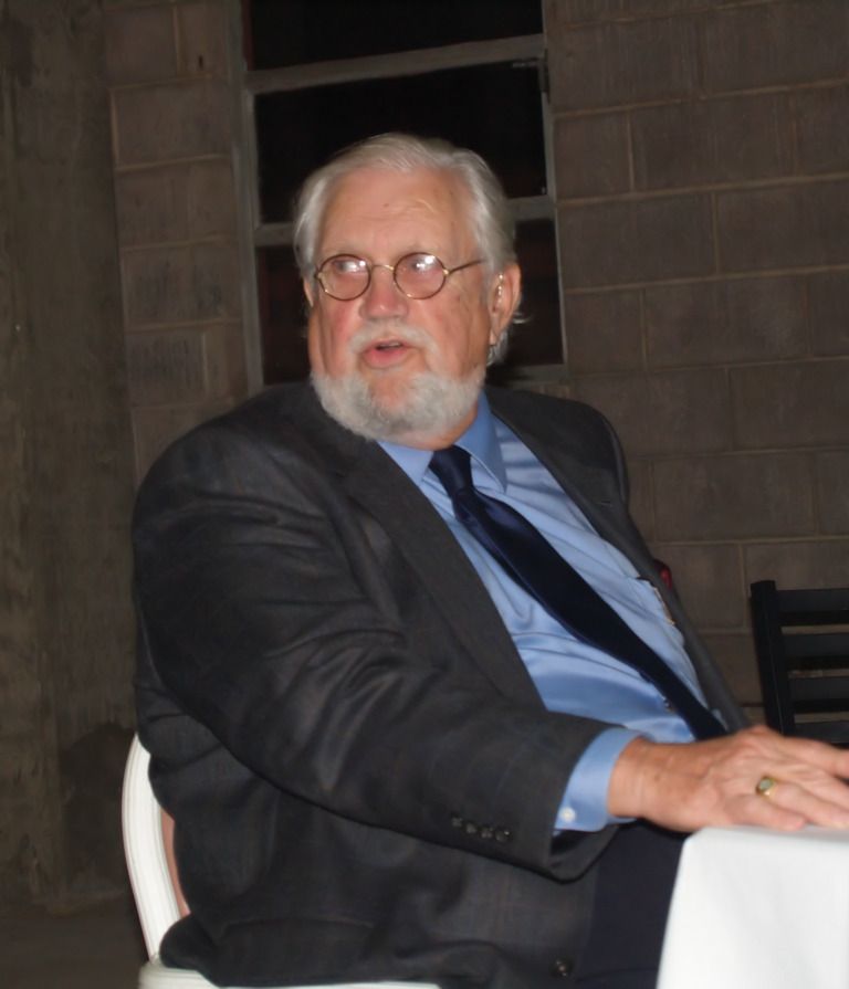
Why Did O'Connor Say What She Did? This one's a bit hard to figure. If Ed Shadid had wanted or needed a foil who would present, as the antagonist to the protagonist, a springboard to his more substantive comments about a convention hotel, it would be hard to imagine a better one than O'Connor presented with her opening remarks on June 11, 2013.
Why would O'Connor have made such a huge blunder? Perhaps it was because in her own mind she had melded and blurred the content of the MAPS 3 campaign, September 2009-December 2009, with the content of the CSL study, finished between 2007-2009, when she made her remarks on June 11, 2013, 3½ years after the MAPS 3 vote ...
The convention center hotel project WAS [emphasis hers] mentioned as a part of the MAPS 3 campaign literature and campaign materials as a part of the Phase 1 development of a new convention center.
O'Connor's completely inaccurate and false misrepresentation of history is perhaps due to (1) her ignorance or forgetfulness of what publicly transpired during the MAPS 3 campaign, and/or (2) her familiarity as an insider who was privy to the Chamber's CLS study (or studies). She may have simply confused the public campaign with the Chamber's private study and made no distinction between the two. Doubtless it was not her intention to be Shadid's foil in making the inaccurate statement that she made. Regardless, in her public words on June 11, she made a wholly historical blunder, and one which rather nicely played into the hands of and setting up Ed Shadid's rejoinder and his other comments, which followed her own presentation. Hearing O'Connor's remarks, Shadid may have been thinking to himself and inwardly rolling his eyeballs upward while sitting on the City Council's horseshoe, saying, "Thank you, god."
This post is nearly done but more will shortly follow.
This haunting tune by George Harrison strikes me as particularly poignant this week in the Oklahoma City metro, as the city of Moore and other metro communities experienced yet again the horrors that Mother Nature can bring. Some (Westoro Baptist Church, Kansas) submit that the tornadic devastation represents the wrath of god. Others count god's blessings for those who survived, but (by inconsistent logic, I'm thinking) don't mention god's wrath upon those who didn't or were otherwise devastated. Others submit that Mother Nature just is what she is, not invoking a deity one way or another. See this CNN Wolf Blitzer video about that. Count me in the latter group. You are, of course, free to take your pick. Regardless of your religious inclination, this week has been bad, very very bad, in Oklahoma City. It has been yet another week that Oklahoma City has gently weeped.
Above, While My Guitar Gently Weeps was performed at the 2004 Rock and Roll Hall of Fame induction ceremonies in which George Harrison, Prince, Jackson Browne, The Dells, Bob Seger, Traffic, and ZZ Top were inductees. In the above tribute to George Harrison by Tom Petty, Dhani Harrison (George Harrison's son, to the right of Tom Petty), Jeff Lynne, Steve Winwood, and Prince (in the red hat), the melancholy tune was beautifully performed.
Our deepest thoughts, grief, sadness, and yes for those who are religiously inclined to claim either god's damnation or the salvation of those who did or not die or otherwise suffer devastation, our prayers, are shared around the world.
By this time, you've already seen images of the massive destruction in Oklahoma City's sister-city, Moore, earlier this week, and no need exists to repeat those images here. There is really nothing more to say or to see, other than to say that my best thoughts and prayers are out there, too, for whatever they may be worth.
May God bless and mend all those whose hearts are broken and may the dead amongst us have everlasting love and peace.
This is an unbeliever's hope and wish ... or maybe not quite an unbeliever ... that, and that you might like to listen to and see J.S. Bach's While Sheep May Safely Graze ...
... and conclude that not all is wrong with the world, notwithstanding our present and most desperate and lamenting grief.
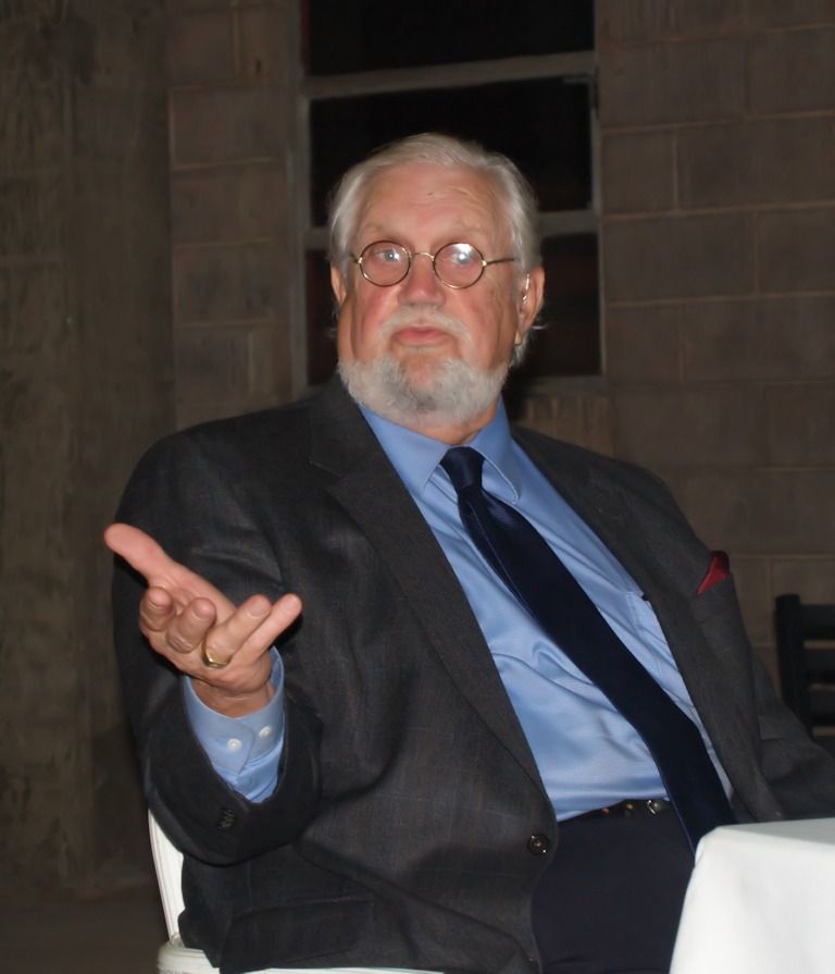
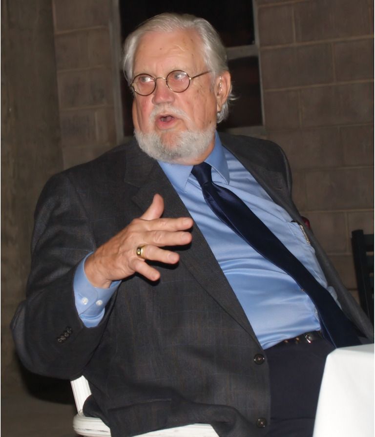
It came as a shock to me to read in Steve Lackmeyer's Oklahoman article that John Lampton Belt died Sunday morning, at the age of 76. Steve's article was published on-line on the same day, March 10, and it appeared in the print version of the Oklahoman on March 11.
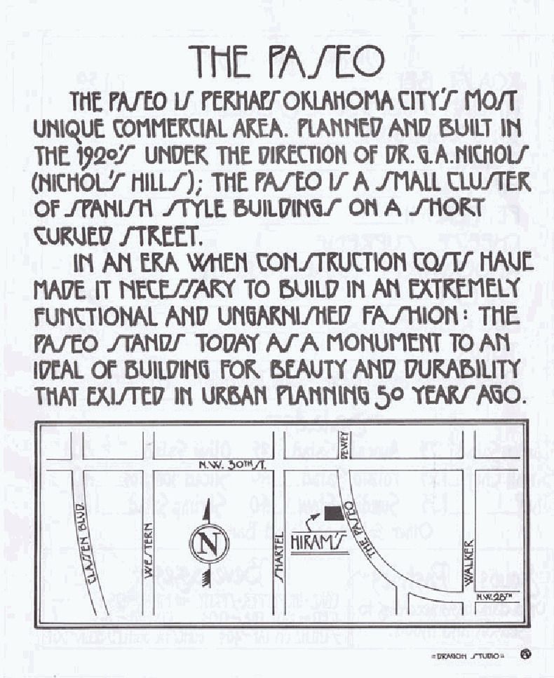
Why is John Belt significant to Oklahoma City history? The answer is simple. John Belt is/was a person who found his comfortable place in preserving and enhancing a historic neighborhood in Oklahoma City, and he singularly established the Paseo District into what it has become today.
Steve Lackmeyer's Articles. After Steve's initial article on March 10-11, he wrote another for the March 12 Oklahoman, and both will tell you things about John Belt and his many contributions to our city, and no need exists for complete repetition here, except to note some snippets:
Belt may be best known for his efforts over three decades to revive Spanish Village, a faded commercial corridor, into Paseo, an arts district that is home to 20 galleries and working studios. The district, located between NW 28, NW 30, Walker and Dewey Avenues, also is home to gift and clothing shops, an event center, live theater, restaurants and bars.
Belt’s efforts to revive Paseo started in 1976 when he was dismayed to learn a favorite sandwich shop where he often ate lunch was about to be closed by a neighbor who planned to buy the building and use it for storage.
In a quick cash upfront deal, Belt did the deal instead, and the restaurant stayed put. More deals followed. As Belt renovated one building after another in the former Spanish Village, artists opened up galleries and the neighborhood enjoyed a slow but steady rise from blight.
In 2010 the Paseo was named one of the Top Ten Greatest Neighborhoods in America by the American Planning Association, one of America’s Top Revitalized Neighborhoods by Forbes Magazine and in 2011, the BBC listed Paseo as one of the Most Beautiful Neighborhoods in the United States.
The above snippets are from Steve's first article. In the second, discussing the property which will be shortly shown below, he said,
At one of our many visits at the restaurant now known as Picasso's, I stared across the street at the forlorn former home of the Spaghetti Factory. The building was a stark white blank canvass in the middle of an otherwise colorful mix of pastels and tile roofs. The building also was the largest on Paseo Drive, and a reminder of what the rest of the strip looked like before Belt's first building purchase in 1976.
The owners were known to be tough negotiators when it came to striking a deal. This would not be a cheap buy for anyone — especially someone like Belt, whose heart was worn on his sleeve.
A couple months later, Belt called me back. Life is short, he explained, and he decided it was indeed time to get the building (once the Paseo Plunge) and bring it back to life after 20 years of dormancy.
Belt then moved quickly to turn the nondescript building into his next artistic masterpiece. I was amused as he had to submit the building designs to the Downtown Design Review Committee, which had been set up just a few years earlier.
How, I wondered, could this group really tell Belt what was and wasn't an appropriate fit for the area when he was the master planner of it all for more than 30 years?
Belt never used that card on the committee members — he respectfully but firmly haggled with the group over their proposed changes. And the project went forward, even without a firm plan on the building's ultimate use.
The building wasn't an easy renovation project. It was huge, without a lot of windows, and built so solidly it would likely withstand a 7.0 earthquake.
We talked about this dilemma a few times. He pondered setting up musical practice studios in the virtually soundproof basement. He considered a balcony coffee shop or restaurant. An arts center, retail complex or community gathering spot all were on the list.
As noted by his friends, John Belt almost always wore a suit and tie amid the more casually dressed “funky” folks who populate the Paseo. Yes, he was an attorney tied to pretty powerful interests in this town. But at heart, he was still the song-and-dance man who thrilled audiences in college, community theater, and briefly, in New York City. He was an artist at heart. And the Paseo, with all its colorful buildings, artists, attractions and events, is the masterpiece that John Belt, the artist, has given Oklahoma City to enjoy for generations to come.
In addition to Steve's articles published in the Oklahoman, in one of his OkcCentral blog posts, he presents a very fine 10 minute video published by OPUBCO, much of it featuring Mr. Belt's overview of the Spanish Village and its transition into the Paseo Distict, complete with the 1960s-early 1970s hippies period and its transformation after that to the modern Paseo District. I've shamelessly embedded that video here, below.
With respect to Mr. Belt, the Paseo Plunge was not the only place for the general public to swim in the 1950s-1960s. For example, Springlake Amusement Park had a fantastic swimming pool area and I think there were a few others as well. But, he can be forgiven for that minor error.
My Personal Privilege. Lots and lots of people have known John Belt far longer than I have but I regard it as a high privilege that I came to know him when I did. My first contact with him occurred by phone when at the JRB At The Elms art gallery back in 2006 or 2007 when I was doing research on the history of the Paseo area, originally called "Spanish Village," the construction of which began in 1929 by G.A. Nichols. While at the gallery with my wife, I spoke with John's wife, Joy Reed Belt, and I inquired about the basis for the Paseo's claim to be "the first commercial shopping district north of downtown Oklahoma City," as was stated in one of the Paseo's websites. She assured me that it was (notwithstanding my observation that Plaza Court at 1100 Classen Drive, built in 1927, was Oklahoma City's first suburban shopping center) and she suggested that I might want to speak with her husband. I said that would be great, she got him on the phone, and we spoke with each other for the first time.
Truth is, I don't remember much about that conversation ... I just remember that it happened. My first blog post about the Paseo occurred shortly thereafter, in early May 2007. It was followed by my second post later in the month about the 2007 Paseo Arts Festival.
Some time passing, in the pre-organization days of RetroMetro OKC, probably in 2009, Mr. Belt was the guest speaker at a brown-bag lunch at the Oklahoma City downtown library, and his presentation was fascinating. I was pleased that he recognized me and gave me kudos for my Paseo research. Enter ego bump number 1 for Doug Dawg.
More time passed. Sometime in 2011, October I think, John contacted me and wondered if I might do some updating on my prior Paseo posts and I said that I would if he would help, and he quickly volunteered. We had lunch at Picasso's and then he gave me a private tour of the former Paseo Plunge property that he had purchased; later, we had another meeting at his law office at NW 50th & Western ... the latter being perhaps more like an Oklahoma City museum than a law office. A very nice friendship was formed during this time and (unless my memory has totally failed me) I understand from my wife that John's wife said to her that John had referred to me as his "new best friend," which, of course, pumped up Doug Dawgz ego several more notches, whether deserved or not. I mean and let's get real, John Belt was a person who was making Oklahoma City history ... I was merely an observer who was writing about it.
Then, on November 7, 2011, John hosted a meeting of RetroMetro OKC and made a splendid presentation at the formerly decrepit property that he had purchased and was completely reinventing at great personal expense, the old Paseo Plunge, and I took a number of photos of John and the re-purposed property. My original intention was to publish these photos more than a year ago, but I never did. It is fitting that I finally share those photos with you now as a tribute to John Lampton Belt, even if tardily done.
The Paseo Plunge. I've given some description of this property and its history in a May 2007 article. It is and was located at 3010 Paseo. First, I posted a few pics of what it looked like in early May 2007, one of which is shown below:
In a nutshell, the Spanish Village Bathing Pool opened in 1933 and was not originally within a closed building, and by 1934 it was named the "Spanish Village Plunge." By May 1944, it was renamed the Paseo Plunge. The pool closed by the early 1950s apparently in response to the 1949-1952 or so polio scare which resulted in the closing of swimming pools around the country. In the video above, Mr. Belt said that the polio scare was in 1957, but I think that he was mistaken about that. In any event, in July 1954, the revamped property reopened and became the Jamboree Surf Club, a private member club operated by Mike Samara. By that time the pool was surrounded on all sides by high walls to assure privacy but was still open-air at the top. A July 11, 1954, Oklahoman article said, "On the first floor of the main building are lockers and dressing rooms. On the second floor, on the same level as the sun deck, is a snack bar and lounge." A May 22, 1955, Oklahoman article said, "The Jamboree Surf club, rebuilt and enlarged from the old Spanish Village plunge, is one of the finest of its kind in the southwest. The concrete apron surrounding the large pool is divided into sunlit and shaded area. A spacious, elevated sun deck borders the pool on two sides." In May 1956, ads appeared in the Oklahoman again naming the pool the Paseo Plunge, open to the public, and those ads continued into 1960. The terminal date of the Paseo Plunge as a swimming pool has thus far eluded me.
By summer 1968, Sussy's Snack and Pizza Bar had opened at 3010 Paseo, and I am guessing that to be the time that the pool and property became totally enclosed, as well as re-purposed. A September 12, 1968, Oklahoman ad announced that "Sussy's Frozen Spaghetti with sauce" was available at that location.
In December 1977, the Spaghetti Factory grand opening occurred at the same location. At the time, one could have "dinner & disco" – spaghetti, pizza, and disco by the Wolfman." The Spaghetti Factory continued through 1989. A July 27, 1979, Oklahoman article described it: "Nestled in Oklahoma City's Paseo district, the Spaghetti Factory's long white exterior camouflages an inside decor which can best described as 'early nondescript.' ¶ A diner who walks through the front door is suddenly confronted with odd electronic devices on the wall, and what they are is anyone's guess."
By the time that I took the photo shown above in May 2009, the property had been unused for many years (Steve's 2nd article says for 20 years) and was on the market for sale. It was an eyesore and a huge blemish on the Paseo District that Belt had been earnestly developing for several years.
In that May 2009 article, I said,
At the moment, this former "pool" property has got to be one large negative to The Paseo today. It is large, it is empty, it is in disrepair, and it will take significant investment to change all of that.
The significant investment came from none other than John Lampton Belt who purchased the property under the name of Paseo Village on December 11, 2009. Lackmeyer's 2nd article gives some description of Belt's intention for the property.
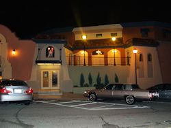
The New Paseo Plunge. By November 7, 2011, the Paseo Plunge had a new look:
Mr. Belt invited RetroMetro OKC to meet at the work-in-progress of the Paseo Plunge on November 7 and have a gander at what occurred thus far and to see and hear him make a presentation of The Paseo's history. His investment and vision for this once decrepit property were staggering. More images from that meeting are shown below.
1 - Looking north from Plunge
2 - Looking south
3 - Looking west from Plunge
4 - Looking south at Plunge
5 - Looking east at Plunge
6 - Plunge Entrance
7 - Closer look at 2nd floor Inside view of the lighted window is shown in #12, below
8 - Art window above entrance
9 - Closer look at the art
10 - Old fashioned freight elevator
11 - Part of spacious 2nd floor
12 - Window looking west
13 - Preparing for meeting
14 - Preparing for meeting
15 - RetroMetro starts to assemble
16 - RetroMetro meeting starts to assemble
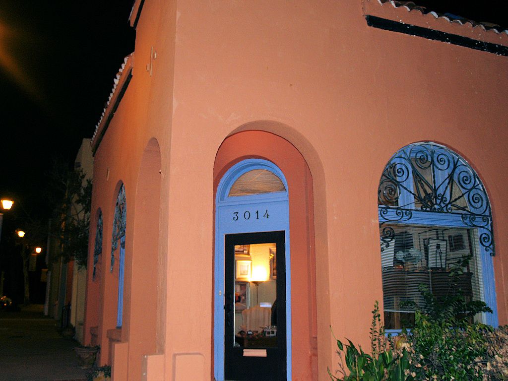
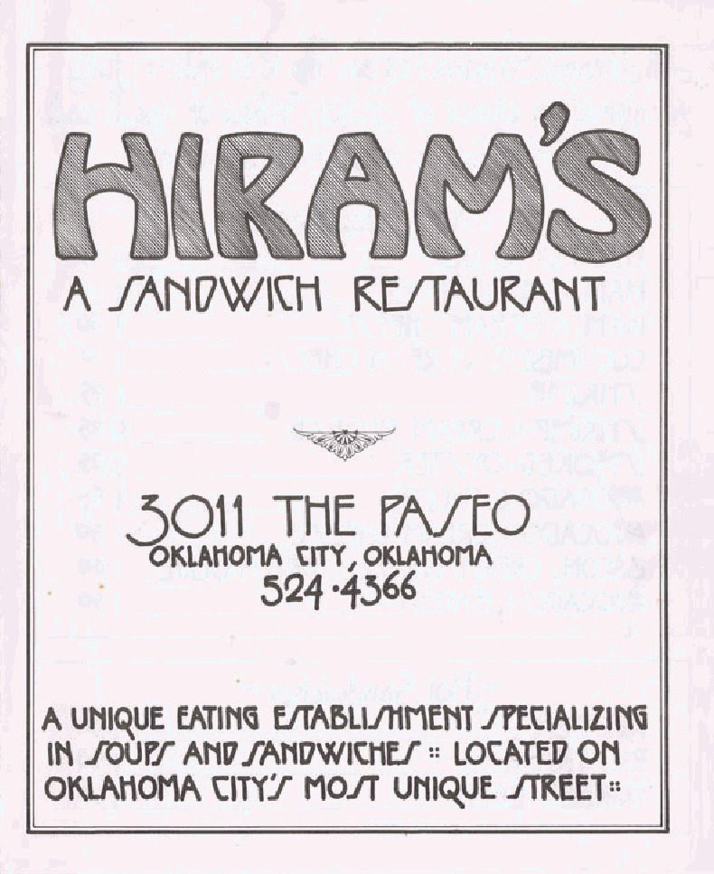
17 - John Belt explains how he became involved with the Paseo - to save Hiram's, his favorite sandwich shop
18 - Hiram's sandwich shop
19 - Hiram's location
20 - Photos of John Belt during his presentation
21
22
23
24
25 - After presentation
26 - In basement
Photos 26-34 show the Plunge's basement, where the bottom of the pool originally was. Probably, during Sussy's Snack and Pizza Bar's tenure (1968- ?), much of this space was converted to large freezers to store frozen pizza for marketing outside the property and around the state. In photo 29, "pass through" windows between freezer rooms can be seen whereby pizzas would be passed from one room to the next. At great expense and difficulty, the floor had been leveled-out and solidified. As will be observed, much work remained to be done, e.g., old pipes and pumps.
27
28
29
30
31
32 - sump pump
33
34
35 - Leaving the meeting and looking north at artwork on a building on the Plunge's north side, symbolic of Belt's influence in the Paseo District
I've not returned to the Plunge since the November 2011 meeting so I cannot report on changes since that time. A graphic rendering appears at http://www.paseoplunge.com/, shown below, the text simply reading, "The Paseo Plunge is currently under renovation in the beautiful and renowned Paseo Arts District in Oklahoma City, Oklahoma."
Hopefully, John Belt's survivors will do what they can to see that his vision for this property continues and that it becomes a reality and a fitting testament to his dreams and vision.
Oklahoma City will forever be in your debt, John Lampton Belt, for all that you dreamed and did. I'm not particularly a religious person, but, still, I say, "Thank you, John Belt, and may God bless you and look fondly upon your soul," just as we do here amongst the living.
This is a test question:The first "legal" settlers in Oklahoma City acquired their rights on:
(1) April 22, 1889, Land Run
(2) Earlier than the Land Run
If you chose (1), amazingly, you may well be mistaken; if you chose (2), you are just as amazingly, but more likely than not, correct.
How can the second choice possibly be correct? Most if not all established historians and other writers take it as a given that land in the Unassigned Lands could not be legally acquired prior to the April 22, 1889, Land Run. Boomers couldn't; Sooners couldn't. The notion is so ingrained that it is almost universally assumed to be a "given," something beyond dispute, beyond being questioned.
But are legitimate Land Runners really all there were in the context of legitimate claim holders to that part of the Unassigned Lands which today comprise a part of Oklahoma City?
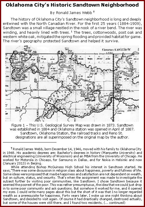
Not necessarily. There were arguably if not most likely a handful of black freedman who settled in Oklahoma City south of Reno, east of May, in 1884, in part of the area that became known as "Sandtown," more particularly in the Sandtown area that I'll call "the boot," in the bend of the North Canadian River which is more or less in the Lewis Addition to Oklahoma City, described below.
The fact that the Sandtown area was a black neighborhood in Oklahoma City in early Oklahoma City annals is not disputed by anyone. But, the issue of how and when those black residents came to be there in the first place has not been investigated by any Oklahoma City historian, save one, Ronald James Webb.
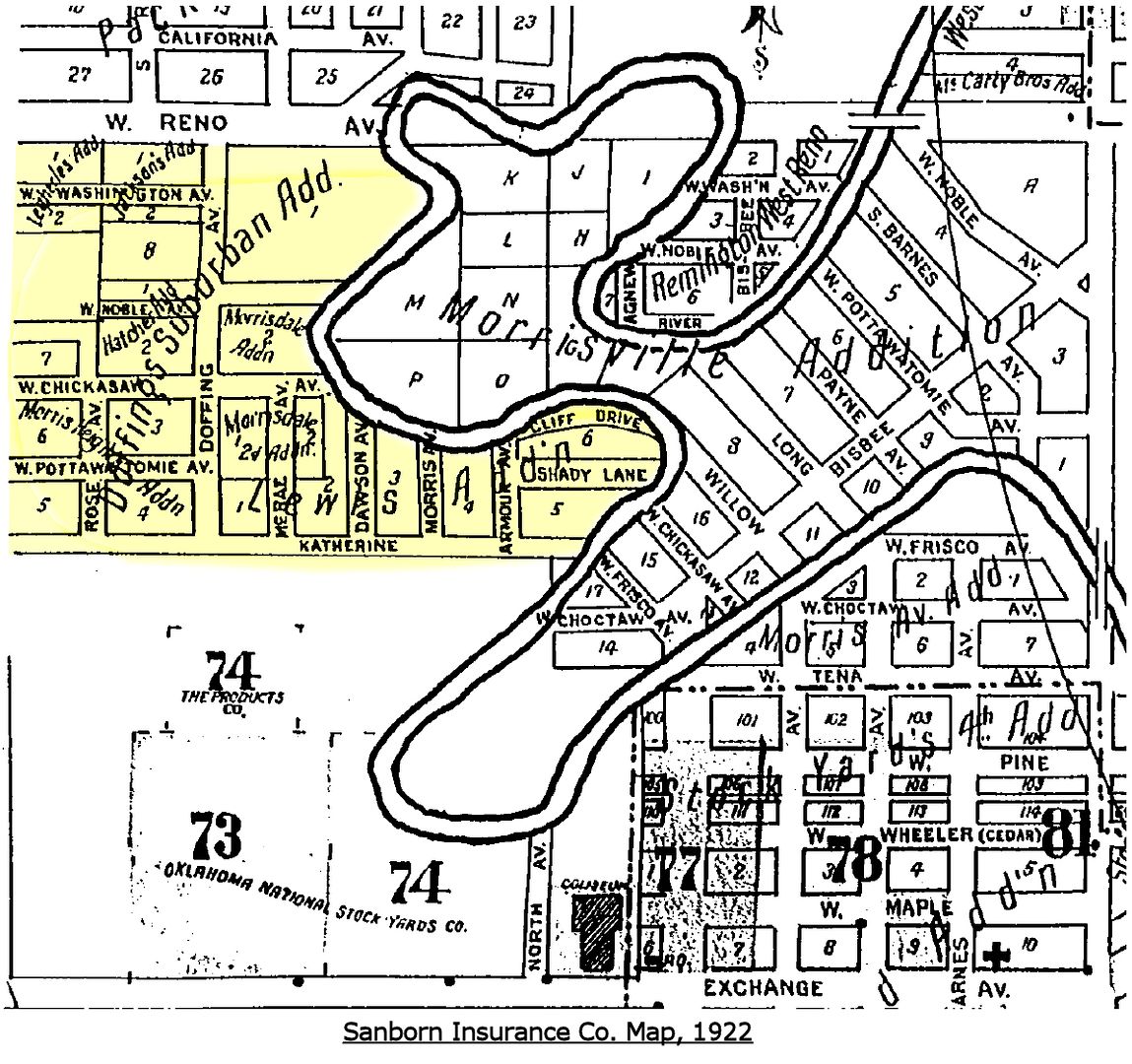
Sanborn Ins. Co. 1922 Map Showing The Sandtown Area
INTRODUCTION. The "Five Civilized Tribes" residing in Indian Territory before the Civil War owned African American slaves, but after the Civil War they were freed, hence their name, "freedmen." This article develops the notion that some of them came to reside in the Sandtown area in 1884, five years before the April 22, 1889, Land Run, and that they continued to reside there from that time for as long as the Sandtown community continued to exist. As well, it provides as much information about their community, life, and environment as I'm able to tell.
In a September 29, 1997, Oklahoman article by Melissa Nelson, "Memories Help Sandtown Area Come Alive," she wrote:
William Welge, the Oklahoma Historical Society's archive director, said his organization has no records on Sandtown's history. ¶ Welge said he doubts the claim by Antioch Baptist Church at 2727 SW 3 that it was founded in 1885. That was before the unassigned lands were opened to public settlement. ¶ But Welge said former slaves known as freedmen could have settled the area under a federal program to relocate southern blacks. ¶ "It's unfortunate that the Sandtown area is largely forgotten and has been totally ignored by historians," he said. "Really, there are only a handful of people who [illegible] it ever existed."
Are the claims of these freedmen and their descendants imaginary, as OHS historian Bill Welge suggested, or are they real? If real, the written history of the origins of Oklahoma City requires a rewriting so that written history matches factual reality. In addition to tracing the history of Sandtown, this article explores the possibility that, like Ralph Waldo Emerson's Invisible Man, these black men and women who collectively comprised "Sandtown" did exist even if they have been invisible in Oklahoma City's written history.
PART 1: THE RESEARCH AND WRITING OF RONALD JAMES WEBB. While doing my research on Oklahoma City's Sandtown, one of the links I followed was to www.sandtownhistory.com (which doesn't appear to be working as I write this text). In that website, a link was present to "History of Sandtown," or something like that. When I clicked the link, the referenced internet page was no longer available. But I also found an email address for Mr. Webb and I began an e-mail discussion with him which turned out to provide a treasure trove of information ... a godsend, actually.
Due to his host's web page formatting issues, he explained, the paper that he'd written in 2005 was no longer available on that website ... but, he asked me if I would like to have a copy.
Would I like to have a copy? Hoorah! Cha-ching! "Are you kidding?" I replied. Of course I would. To shorten the story a bit, he furnished me a copy of his paper in Microsoft Word format; I converted it to WordPerfect format (the word processing software that I use); I then created a PDF version of his paper, complete with bookmarks. He kindly allowed that I re-publish his paper here. Aside from formatting changes, the only difference between his 2005 research paper and the 2013 re-publication here is that I have added a footnote which gives his own background information and describes how he became interested in Sandtown, as follows:
Ronald James Webb, born December 14, 1946, moved with his family to Oklahoma City in 1948. His academic degrees are: Bachelor's degrees in history (Marquette University) and electrical engineering (University of Wisconsin) and an MBA from the University of Chicago. He worked for Motorola in Chicago, for Samsung in Dallas, and for Nokia in Helsinki and now (January 2013) in Beijing.
While attending Bishop McGuiness High School his interest in Sandtown started. He says,"There was some discussion in religion class about happiness, poverty and fullness of life. Some ideas were proposed that maybe happiness and satisfaction are not dependent on wealth, but on culture, status, and security. That's when the assignment was made to investigate the subject further by visiting poor communities, like Sandtown. I chose Sandtown because it seemed the poorest of the poor. This was rather presumptuous, the idea that we could just drop in to some poor community and ask questions. But somehow it worked for me, and it opened my eyes. I could write many pages about this but the short of it was that I no longer regarded wealth as a prerequisite for happiness. Forty years later, I woke up one night thinking about Sandtown, and decided to visit again. Of course it had drastically changed, destroyed actually, but some of the houses were still there, and I found two residents, Glennie Hunter and Lucile Williams, who had been born and raised in Sandtown, I mention these in the article. Glennie Hunter was the most valuable source of information, she provided many photos, stories and a fairly complete history of Sandtown. I was hooked. I then made a systematic study of Sandtown, starting with the Antioch Baptist Church, which had been located in Sandtown from 1884 until 1999, according to their records. I spent hours at the OHS, with help from a friendly worker there. Consulted old newspapers, Polk City Directories, Sanborn maps and census data. I spent hours at the land and tax offices researching warranty deeds starting with April 22, 1889. I read several books about OKC, including McRill's classic And Satan Came Also, and Stan Hoig's The Oklahoma Land Rush of 1889. McRill was involved personally with Sandtown, and Hoig provides excellent detailed information about what happened around OKC in the 1880's before the Land Rush. I found a monograph about Sandtown culture, written by Phelicia Ann Morton, a Sandtown resident who went to Cornell University, graduated and got a Master's degree there. In short, it became a passion for me, culminating in this article."
"I sent the article to the OHS. After several months without response I inquired again, did they receive it? Again, no response. So after six months, I created a website www.sandtownhistory.com, and published an abbreviated, but more decorative version, online. I then was contacted by the head of the OHS who said that she just started in the job, and found my manuscript in an old shoebox. I told her that I had already published the article on my website, and she said that it was regrettable, but the OHS cannot publish anything that has been published already elsewhere."
As noted above, Mr. Webb's article was originally self-published in 2005. This republication is made in January 2013, with only formatting changes to the original.
Mr. Webb's 25-page single-spaced article includes 14 images and 54 endnotes which identify his sources. In addition to establishing a legitimate basis for the claim that Sandtown's origins trace to 1884 and continued thereafter, his article contains information about the people, community, culture, and environment in and around Sandtown, much of that based upon interviews with Sandtown residents in 2005. The paper is seriously researched and is written by the pen of a scholarly author, one not to be taken lightly. We are all indebted to Mr. Webb for allowing his paper to be available here, for all to read.
Click here or click the image below to open and/or save to your computer Ronald James Webb's "Oklahoma City’s Historic Sandtown Neighborhood."
The author describes Sandtown before and after the passing of Jim Crow ordinances in Oklahoma City which established residential white and black "blocks," and he explores the impact of the Packingtown district in and after 1906 upon Sandtown residents. Churches, schools, business, and other activities are discussed, as are the environs around Sandtown itself, including conflict with the antagonistic residents of nearby Mulligan Flats. At page 17, this description of Sandtown is presented:
In the 1940’s and 50’s Sandtown hosted weekly block parties between Chickasaw and Pottawatomie (3rd and 4th) Streets on Doffing Ave. Maddie Wright, on the piano, and her husband George on the guitar, got things started on Friday nights. The parties often extended through the weekend. Glennie recalls that "there was never trouble except when Eastsiders came over." The Sandtown community was stable and close-knit. "People looked out for each other and the town was like a big family."
Something about living on the river, the uncertainty and the possibility of imminent disaster, gave the citizens an edgy lust for life that is found today only in places like New Orleans and San Francisco. On the other hand, Sandtown was very stable. People moved into Sandtown and stayed, at least until the packing plants closed.
Of course, the North Canadian River is also described — as the source of both early day sustenance and the devastation caused by occasional flooding. River straightening from 1953 to 1958, construction of the I-40 crosstown expressway in the mid-1960s which split Sandtown apart, and the closing of the meat packing companies from 1960 through 1981, all contributed to the demise of this first and most historic neighborhood of Oklahoma City.
The last image in Mr. Webb's article portrays Sandtown over time ... after the I-40 crosstown was built and which split the region, and after the relocation of the North Canadian River, and it provides an index locating some of Sandtown's once-existing structures.
Thanks, Ronald James Webb, for allowing that this outstanding piece of work be made available here and for your contribution to Oklahoma City history.
PART 2: MY OWN RESEARCH. First, some definitions and clarifications are in order. Although sometimes reported as "Sand Town" in the Oklahoman, the correct name for the black community south of Reno, east of May Avenue, north of Packingtown (more particularly, north of Katherine Street [SW 6th Street]), and west of Agnew (broadly defined -- Sandtown was not as far east as Agnew; the old riverbed of the North Canadian River was Sandtown's eastern border) is "Sandtown," one word. Secondly, Sandtown is not at all the same as the the Walnut Grove area south of Bricktowown or the "May's Camps", also called "Community Camps" or "Hoovervile Camps" which existed during the Great Depression, nor is it the same thing as "Mulligan Flats," the latter area being mentioned in Mr. Webb's article.
Last, it may be that a totally different area known as "Sand Town" existed near the North Canadian River south of the warehouse district that is known as Bricktown today, perhaps what Dr. Blackburn had in mind for the Walnut Grove area which he labeled "Sand Town." In this post on Deep Deuce history, I reported that our renowned Oklahoma historian Bob Blackburn said,
From 1889 to the 1930s Bricktown was a battleground for social justice and the birthplace of cultural diversity in Oklahoma City.
It began when some of the first 200 African-Americans attracted by the land run settled in Sandtown, located along the north bank of the river east of the Santa Fe tracks. From there, the black community grew northward as jobs were created and new waves of immigrants arrived looking for a piece of the promised land.
STOP, already. If an area did exist where Dr. Blackburn said, known as "Sandtown" or as otherwise reported "Sand Town,", it was NOT the more historic area more properly known as "Sandtown," south of Reno, east of May Avenue, about three miles west of the Santa Fe railroad tracks, that arguably if not most probably existed in 1884. The settlers in the "real" Sandtown almost certainly appeared in their chosen area five years before the 1889 Land Run, or, at least, I am so persuaded. No disrespect at all is intended to Dr. Blackburn in saying this ... instead, I am reminded of the words of William Welge, mentioned at the outset of this article,
William Welge, the Oklahoma Historical Society's archive director, said his organization has no records on Sandtown's history. * * * "It's unfortunate that the Sandtown area is largely forgotten and has been totally ignored by historians," he said. "Really, there are only a handful of people who [illegible] it ever existed."
Déjà vu, ala Ralph Waldo Ellison's, The Invisible Man. "The Sandtown area is largely forgotten and has been totally ignored by historians." Enough said.
Second, let's have a look at a few maps showing the Sandtown area.
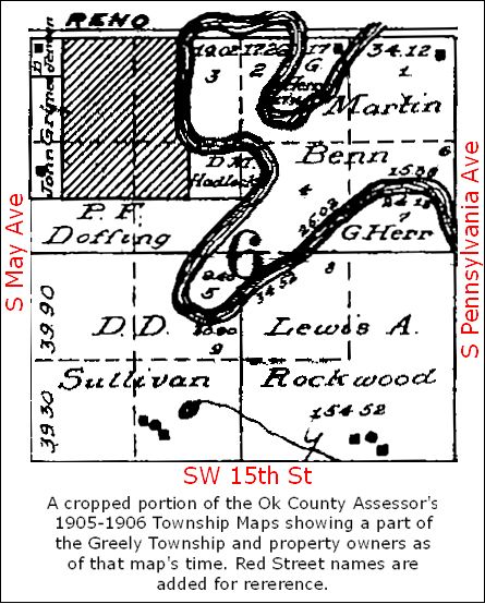
County Assessor's 1905-06 Township Plats. Probably the earliest map available is a crop from the 1905-06 Oklahoma County Township Maps showing part of Greely Township, more particularly, Section 6, Township 11 North, Range 3 West of the Indian Meridian, Oklahoma County, Oklahoma:
Mr. Webb's article includes this map and discusses early real property transactions involved with early-day Sandtown real property transfers. Particularly, he notes that the small area at the river's bend owned by D.M. Hadlock was acquired by him in January 1906 and was the "original" or "old" Sandtown before its expansion west toward May Avenue and north toward Reno.
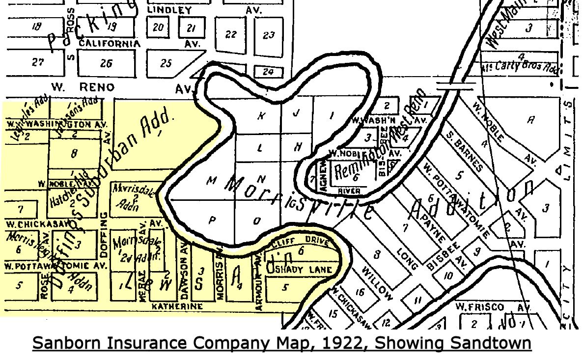
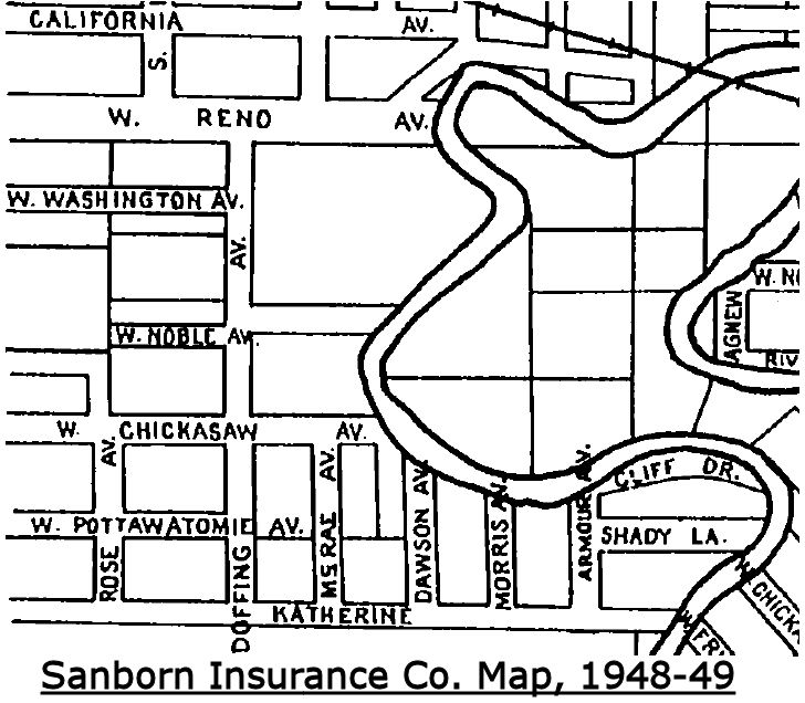
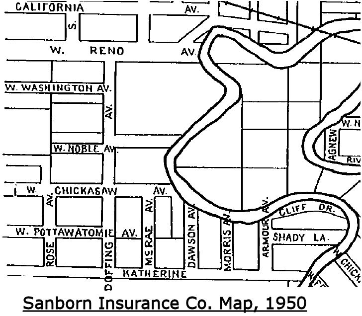
Sanborn Insurance Co. Maps. Sanborn Insurance Company maps between 1922 and 1955 show the Sandtown area in "Index" maps but none of those Sanborn maps present detailed maps of the area as was generally done with other areas within the boundaries of Oklahoma City. Nonetheless, the index maps are useful. Click on map images for larger views.
SANBORN INSURANCE COMPANY MAPS
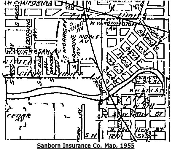
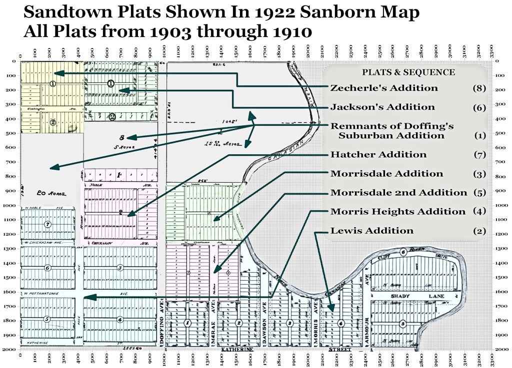
1922 Highlighting Sandtown The 1922 Sanborn Map is particularly important because it alone identifies the plats within Sandtown. The particular plats will be described shortly.
1933
1948-1949
1950
1955
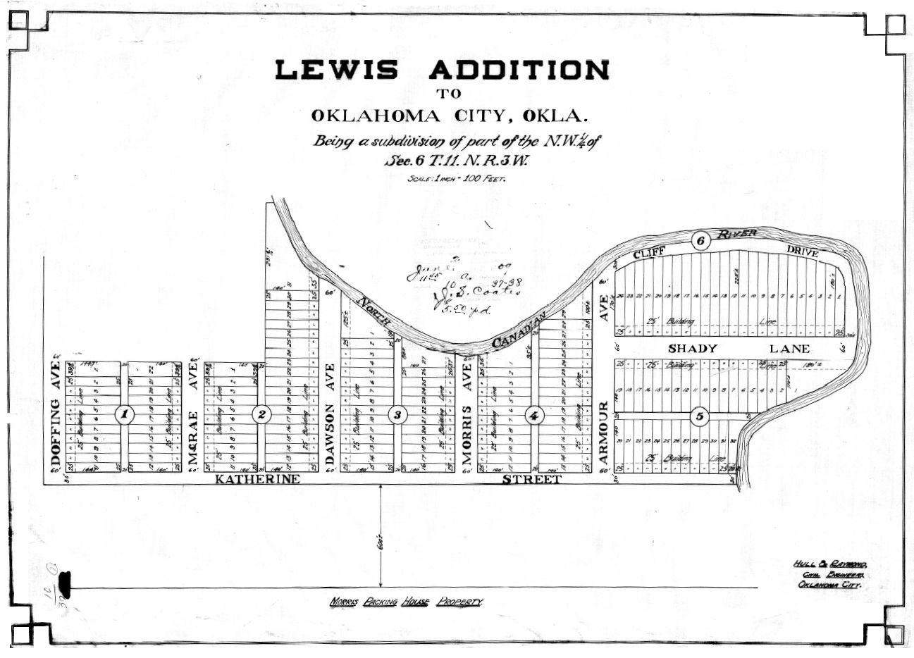
Beginning with the 1922 Sanborn map, the Sandtown area is shown with various street names and those street names remained constant through the 1950 map. About that, Mr. Webb says, in his article when describing Figure 6, "The streets of Old Sandtown were never named. Cliff Drive and Shady Lane appear on maps from the 1920’s perhaps as a mapmaker's joke." With respect to Mr. Webb, Cliff Drive and Shady Lane are present in the Lewis Addition plat, presented shortly, and from which the Sanborn Maps assuredly derived their names. After the filing of the Lewis Addition plat in June 1909, those names were plainly official, even if they may not have been used by Sandtown residents.
The 1955 Sanborn map image, above, is the poorest quality of any other Sanborn map images. Nonetheless, it does show the change in the North Canadian River that had occurred by that time.
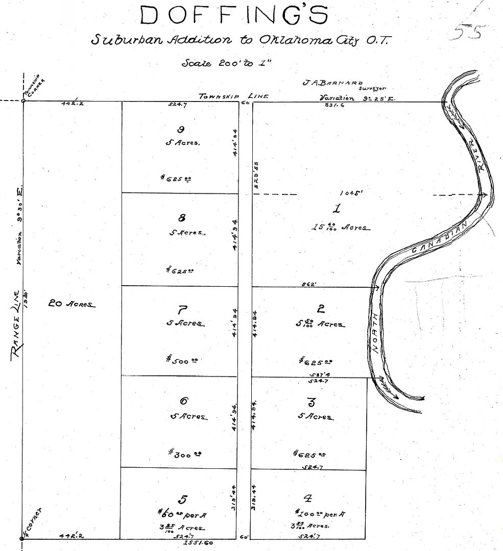
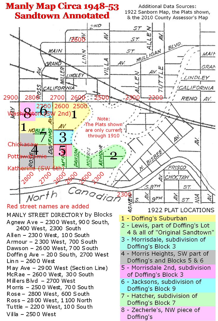
Plats. As of the 1922 Sanborn map, eight plats were filed for record embracing all of Sandtown from 1903 through 1910. The first, and from which the Doffing Neighborhood organization takes its name, is Doffing's Suburban Addition, filed November 18, 1903. Aside from Lewis Addition, it embraced all areas in Sandtown from Reno to Katherine (SW 6) and from May Avenue east to the North Canadian River, many of which areas would be further subdivided during 1909-1910. It did not include the "original" Sandtown area represented by most of the Lewis Addition plat, reminiscent of a boot. All plats are shown below.
1 - Doffing's Suburban Addition was filed for record on November 18,1903, and it extended from Reno on the north, May on the west, Katherine on the south,and a large part of the river-bend area on the east, but not including what has been called the "Old Sandtown" area on the east. Doffing's Suburban Addition was subsequently subdivided by plats during 1909-1910.
2 - The Lewis Addition was the 2nd area to be platted, on June 2,1909, and it included a small piece of Doffing's on the west but more importantly included the river-bend area on the east, the area known as "Original Sandtown." Notice that the street names, "Cliff Drive" and "Shady Lane," are present in the plat.
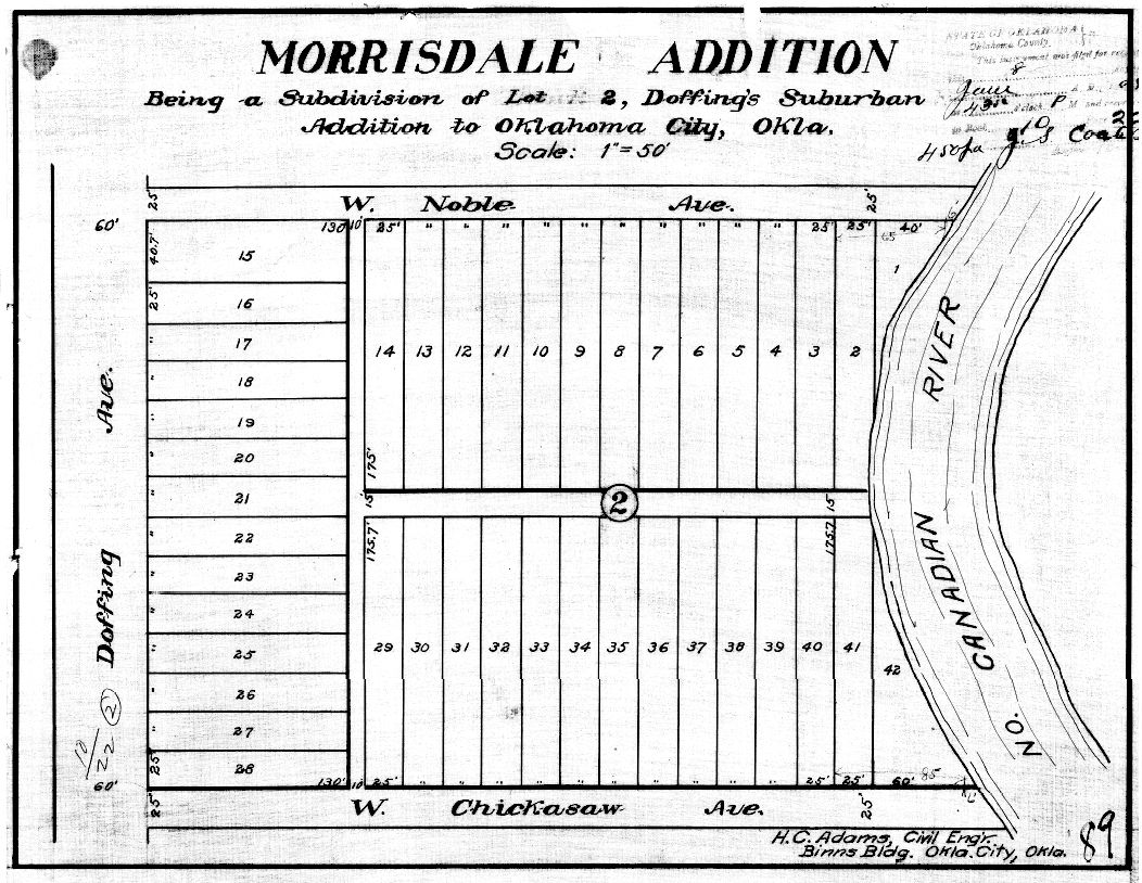
3 - Morrisdale, a subdivision of Doffing's, was filed on June 8, 1909. It was a subdivision of Block 2, Doffings's.
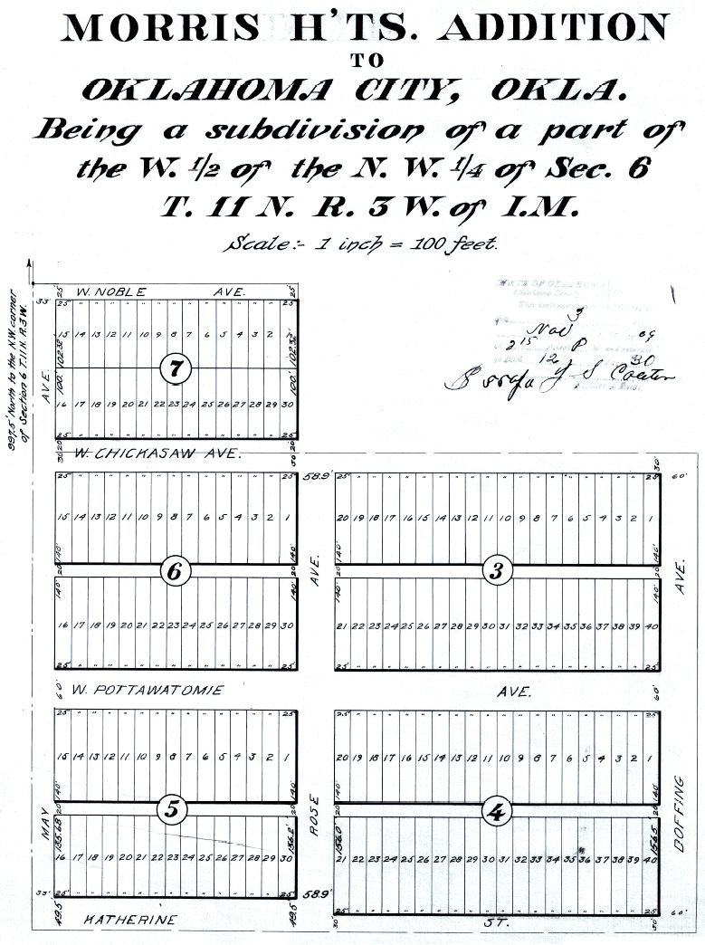
4 - Morris Heights, a subdivision of Doffing's, including part of Block 5, filed November 3, 1909. The Morris Heights plat is notable because it was the only plat in the Sandtown area to contain a restrictive covenant, it reading, "No transfer of lots shall be made to any person or persons of African descent, commonly known as Negroes." However, the covenant did not contain a reverter provision (that property title would revert to its prior owner or to the original owners should the covenant be violated). Without such a reverter provision, such covenants were held to be unenforceable in the courts. Ironically, this area which includes SW 5th (Pottawatomie) immediately east of May Avenue, that piece of SW 5th including the largest remaining remnants of the former Sandtown today.
5 - Morrisdale 2nd Addition was the next area to be platted,on January 14, 1910. It subdivided Block 3 of the original Doffing's Suburban Addition.
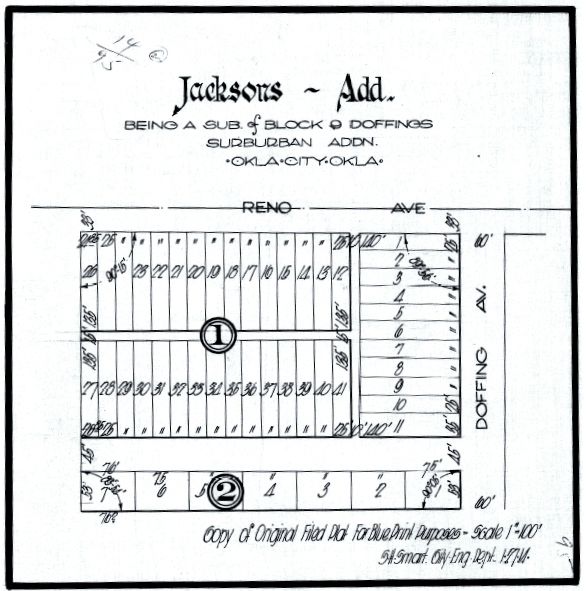
6 - Jacksons or Jackson's Addition was a subdivision of Block 9, Doffing's, flanking Reno on the north and Doffing on the East, filed February 23, 1910.
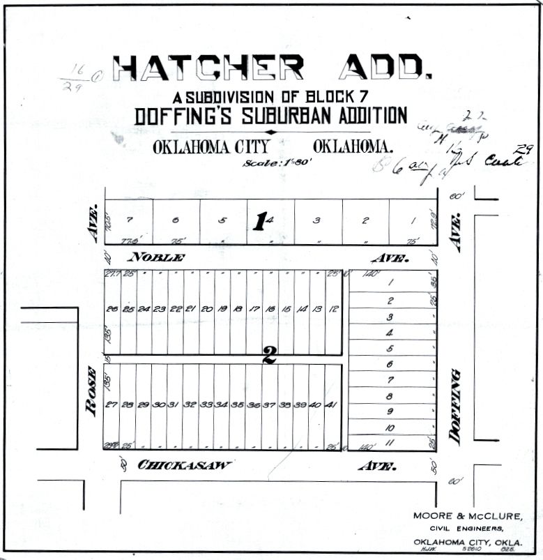
7 - Hatcher Addition was a subdivision of Lot 7, Doffing's Suburban Addition, filed August 2, 1910. The original Sandtown School was located in Block 1, Lots 6 & 7. The school burned to the ground in late 1942 or so. The new school George Washington Carver, was located immediately west of the original school location.
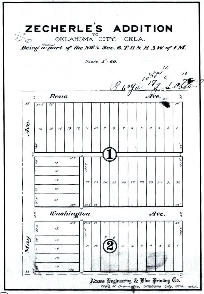
8 - Zecherle's Addition at Reno and May, plat filed on November 14, 1910
How It All Fits Together. I've assembled a Sandtown map which fits all of the above plats into a single image and in which the Sandtown puzzle-pieces are made clear. The map is scaled and the scaled measurements fit the specific and general regions of Sandtown. To see a high resolution image of this map, click here. To see a 1024 px wide image of the map, click the map, below.
Other plats or modifications to existing plats doubtless occurred after 1910 but I've not explored such possible changes, my intent here being to focus on Sandtown as it existed in its earliest days.
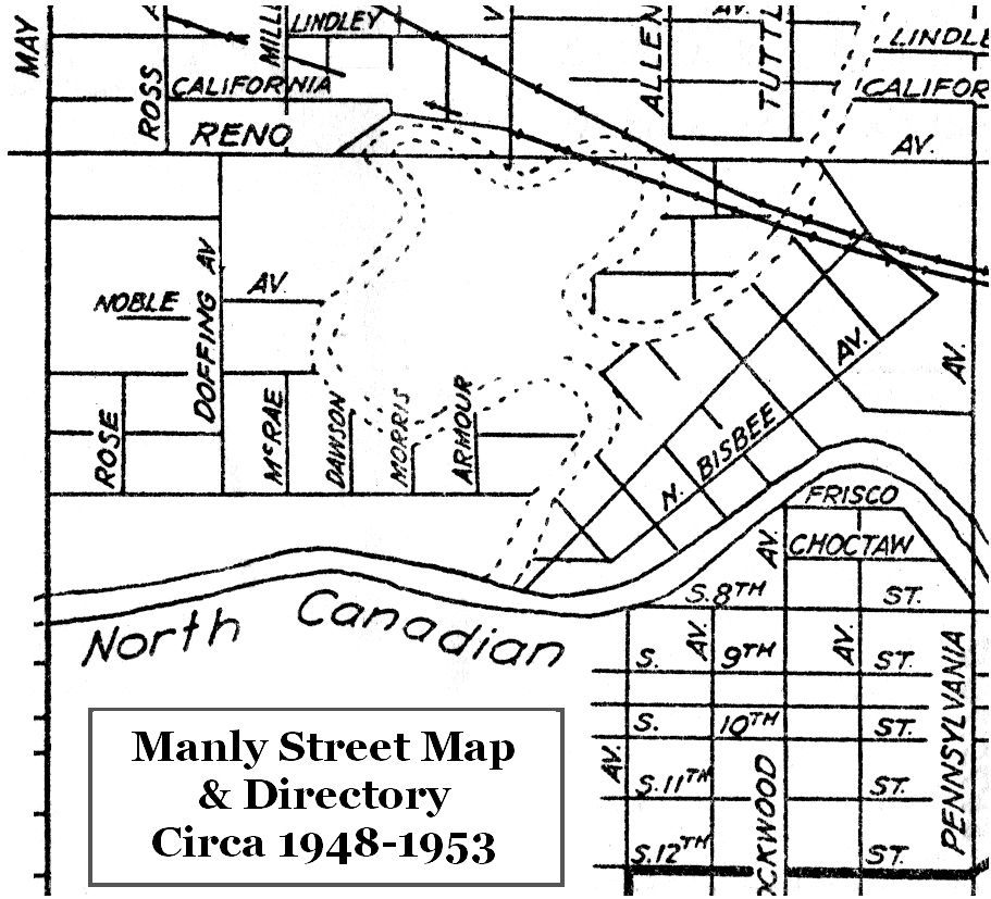
Manly Office Supply Map. Manly Office Supply Company was a long-existing office supply company located downtown in the First National Center. It produced a map of Oklahoma City which appears to span the 1930s and 1940s, perhaps even into the early 1950s, with updates over time. Unfortunately, the map is not dated. I had thought that the copy that I own was published around 1947-1948, but, given that the North Canadian River's location is shown as changed or changing in this map, it may be that this map was published around 1953. Regardless, the map shows the Sandtown area as follows:
The Manly Map is also helpful in getting a fix on particular street locations since it includes a street index. In the expanded, annotated Manly map view below, note that blocks north of Reno had a different numbering system than blocks south of Reno and that they are "skewed." For example, "the Big House casino" mentioned in Mr. Webb's article shows the property located on Reno in the north part of Sandtown. However, the 2500 block on the north side of Reno would locate that property at Villa and Reno, different than Mr. Webb's map. BUT, adjusting block numbers south of Reno for those shown in the Manly Map places the Big House casino just as located in Ron's map.
An expanded and annotated view of the Manly Map is shown below. Manly's Map doesn't include all Sandtown street names but they have been added, largely based upon locations identified in the 2010 County Assessor's aerial map, shown shortly. The annotated map also identifies the plats shown in the 1922 Sanborn Map, they being added from 1903 through 1910. Doffing's Suburban Addition (1903) included most of Sandtown, but it did not include the "Original Sandtown" area shown at the river bend, lower right, which was platted as Lewis Addition in 1909. Other plats may have been filed after 1910. The remnant of the original Doffing's Surbaban Addition after the subsequent plats is shown in yellow.
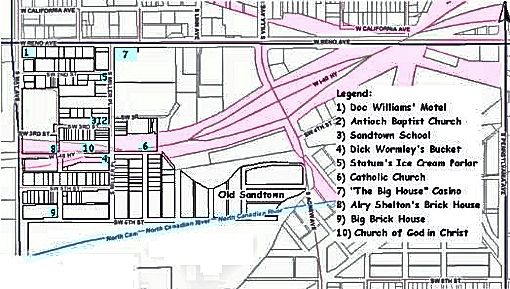
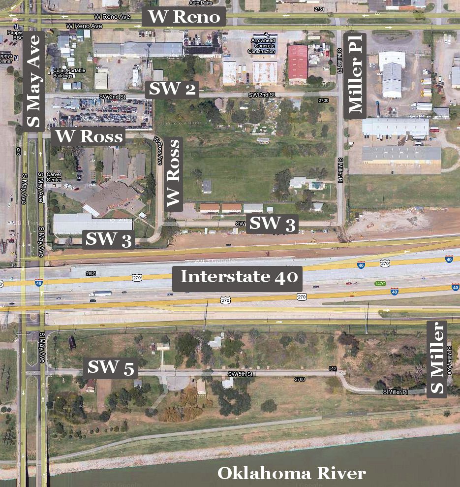
Sandtown In 2013. The Google Map below shows what's left of Sandtown as this article is written. Basically, a slice exists north of Interstate 40, along SW 3rd and thereabouts, and south of Interstate 40, along SW 5th Street. Sandtown's former southern border, SW 6th Street (earlier named Katherine), mostly lies at the bottom of the Oklahoma River.
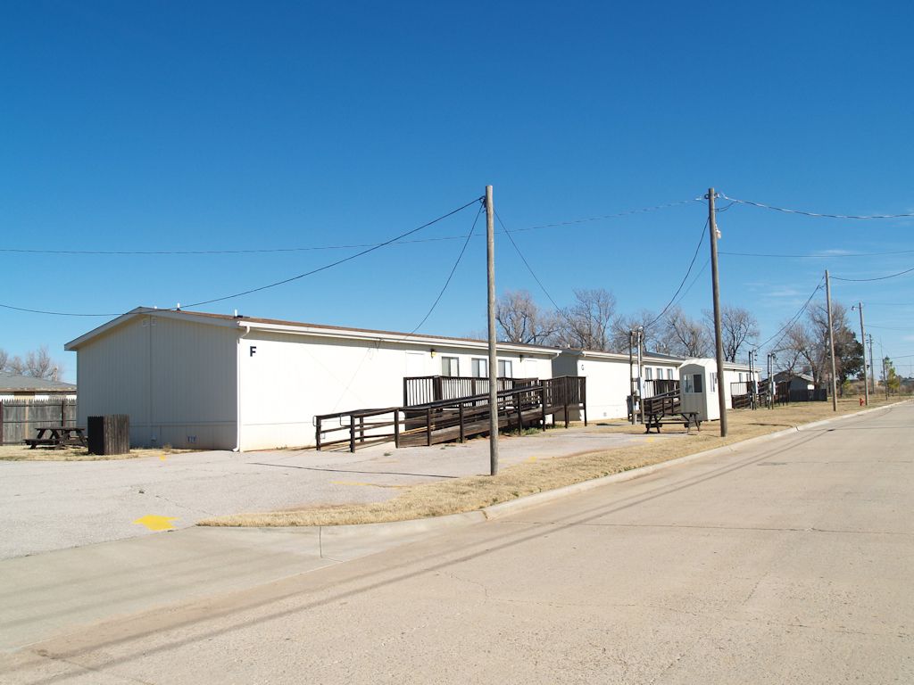
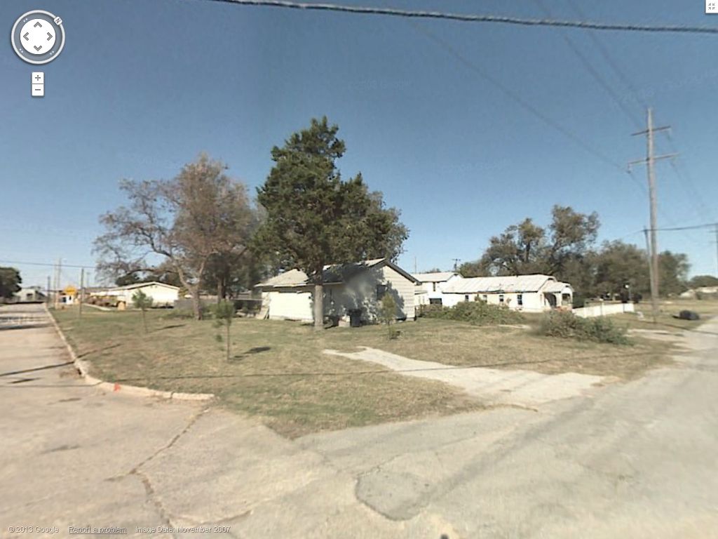
Contemporary Images. On February 4, 2013, I drove through the areas shown in the above map and took some photos. Some items didn't occur to me to take, but I've assuaged my neglect by using images from Google Maps street view. An index of the photographs appears below:
The numbers in the map correspond with the following pictures. It will be obvious that some images are not historic Sandtown structures but I've included the more contemporary buildings for completeness. The thumbnail images shown below are cropped and reduced in size from the larger (1024 px wide) images. Click on any thumbnail to see its larger image.
Buildings North of Interstate 40
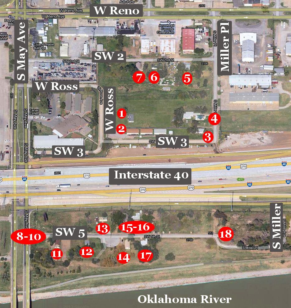
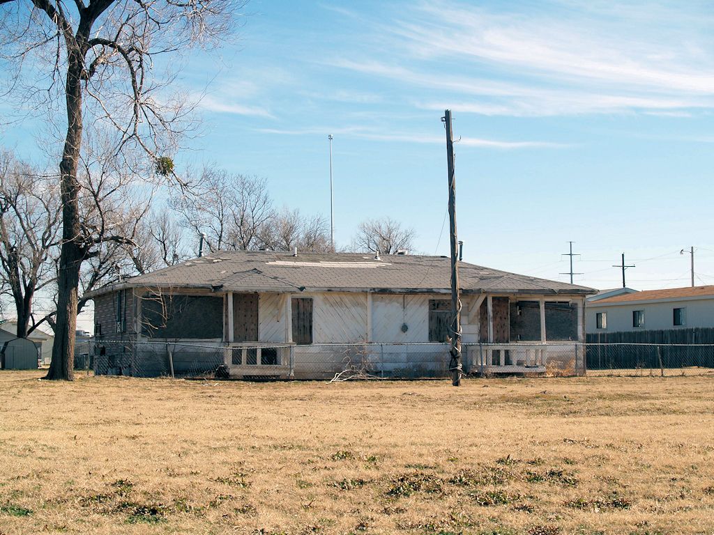
1 - Near W Ross
2 - On SW 3rd
3 - Corner of SW 3 & Miller Pl
4 - On S Miller Pl
5 - On SW 2nd
6 - On SW 2nd
7 - On SW 2nd
Buildings South of Interstate 40
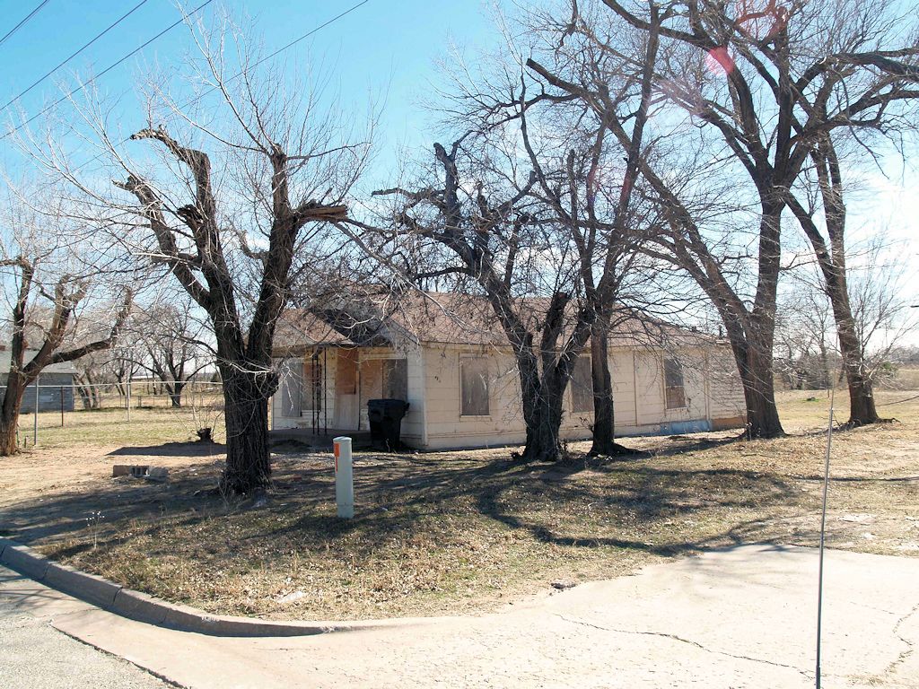
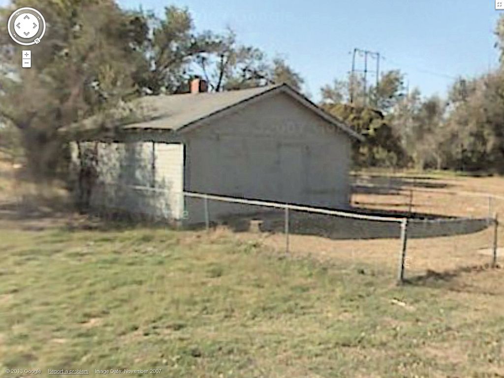
8 - SW 5th From May Ave
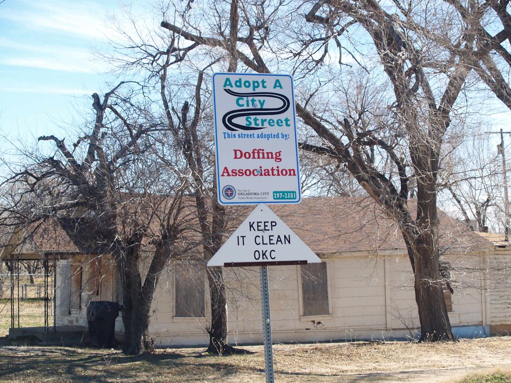
10 - Adopt A Street Sign
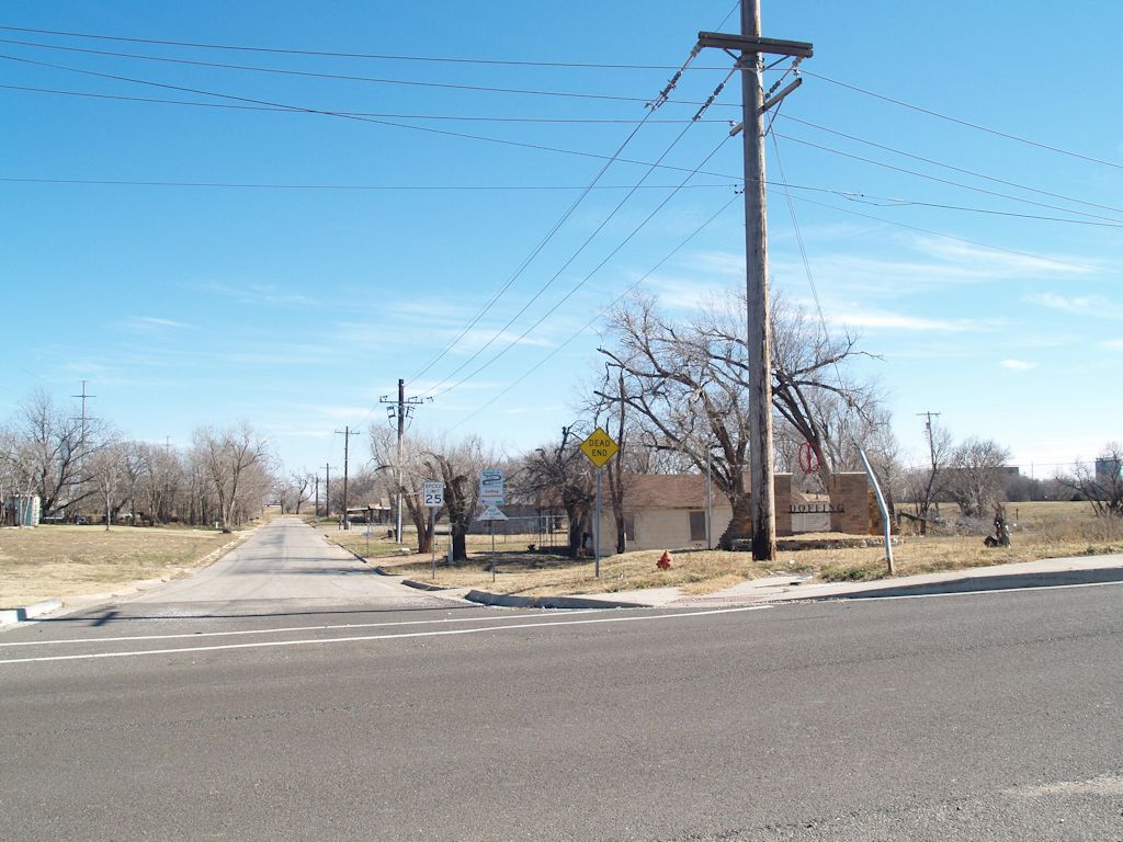
9 - Neighborhood Association Gateway MarkerIn 2006, under the leadership of Dana Lusk Dunn, the Doffing Neighborhood Association was formed. It chose the name Doffing instead of Sandtown, but the association's intent is to embrace the historic Sandtown neighborhood, most of the remnants being on SW 5th Street. In 2007, the association received a $10,000 grant from Oklahoma City to construct this "gateway" edifice on SW 5th Street, on the east side of May Avenue.
11 - On SW 5th
12 - On SW 5th
13 - On SW 5th
I'm showing a larger thumbnail for this image since it was one of the venues for the 2011 Sandtown Celebration.
14 - On SW 5th
15 - On SW 5th
16 - On SW 5th
17 - On SW 5th
18 - At the end of SW 5th, looking west toward May Avenue
2010 County Assessor's Aerial Map. Is the above all there is, all that remains? Yeah, pretty much, and the Google map used above doesn't include all of the Sandtown area. For a full view of what once was Sandtown, I've patched together aerial views from the Oklahoma County Assessor's website, the aerial pieces being taken between March 19 and 29, 2010, and have emphasized the street names shown in the assessor's map. Using the above Manly map as a guide, the original Sandtown area has been highlighted, the curvy part on the east being the former location of the North Canadian River. Click on the image below for a 1024 px wide view. Or, click here for a 2000 px wide image, or click here for a 2,599 px wide image, it showing the actual size of the assembled pieces from the assessor's website. For the original map, 2,599 px wide, without my annotations or highlighting, click here. The assessor's detailed lot and block information will only be readable in the 2,599 px wide views.
More noticeable in the larger views is that the outlines of by-gone streets and street names are observable, e.g., Katherine (same as SW 6th Street), the southern boundary of Sandtown which is shown as mostly being in the bed of the North Canadian River. I guess that the County Assessor's office didn't get the memo that the portion of the river shown is now the Oklahoma River.
Notice that much of the original Sandtown is empty space or, in some parts of the north and northeast areas, commercial property.
What happened — why do contemporary aerial maps, like the above, depict Sandtown areas that were previously occupied by homes, even if decrepit, being replaced by (1) grassland or by (2) commercial property, particularly in the north and northeast areas of Sandtown?
I'm not completely clear about this. Based upon articles in the Oklahoman in late 1962, my first impulse was to opine that the answer probably comes from activity by Oklahoma City's Urban Renewal Authority (OCURA) in the 1960s-1970s. Three 1962 Oklahoman articles cause me to think this way. First, a pair of articles in the October 31, 1962, Oklahoman, reported as follows:
(Article 1) Official designation by the city council of Oklahoma City's first blighted areas was urge Tuesday by the city planning commission. ¶ The planning board adopted and sent to city councilmen a report prepared by Sam B. Zisman, planning consultant, in which recommendations were made for designations of four geographic areas of the city for priority attention of the Urban Renewal Authority. ¶ They include: * * * Reno-May Renewal Area located south of Reno Ave. and east of May in the George Washington Carver School and Doffings Addition area.
(Article 2) Reno-May Area. Planners described this area as "wholly blighted" except for the George Washington school and a few non-residential establishments. ¶ The area has already been disrupted by clearance of right of way for the Downtown Expressway.
The third 1962 Okahoman article, on December 7, says that, among other things, the planning commission's "Reno-May" area report had been approved by city council and said,
Three general areas of blight and a group of seven pocket areas were designated with the last month by the Oklahoma City Council and the city planning commission as suitable for a more detailed study and possible Urban Renewal projects. ¶ The three large areas included are the University Medical Center area, lying between NE 13 and the Rock Island Railroad, N. Lottie Ave. and the route of the future Lincoln Blvd. Expressway; south central area lying between Main St. and the floodway, Western Ave. and the Santa Fe railroad; and Reno-May, an area south of Reno Ave. and east of S May in the George Washington Carver School and Duffings [sic] Addition area.
I have thus far not located later Oklahoman reports or other sources which state, in fact, that the barren parts of Sandtown and/or the commercial developments seen in present day aerial maps were/are the result of OCURA activity such as occurred in the Deep Deuce or Medical Center areas where, after acquisition by OCURA, large areas were transformed into areas of oblivion and grass.
To test my hypothesis, I took a fairly close look at the Oklahoma County Clerk's records after 1962 to see what I could find, particularly those on the east side of Sandtown -- the original Doffings's Suburban Addition in the northeast part which was never broken into lots or blocks, Morrisdale and Morrisdale 2nd Additions, just below that, and Lewis Addition, which formed the southeastern part of Sandtown.
I could locate no instance of property in those areas being acquired by OCURA. Possibly I missed something, and possibly the on-line version of the County Clerk's records are incomplete, but if a conveyance to OCURA was present after 1962, I did not find it.
But I did find a few other things. A number of Oklahoma City notices were filed for record with the Oklahoma County Clerk concerning dilapidated structures in the area and a few tax deeds were issued for failure to pay county taxes. It reads as though Sandtown structures were destroyed, not by OCURA, but by Oklahoma City through its normal processes.
OKLAHOMAN ARCHIVES. I've rather thoroughly reviewed the Oklahoman archives from 1901 to the present time to locate anything I could find which mentioned "Sandtown" or "Sand Town" (since the Oklahoman used both names for the area), as well as some other search words and phrases, and that process resulted in hundreds of finds. Many were pretty useless as far as shedding light on Sandtown's history is concerned. A summary of what I found is the following — and all that follows assumes that the Oklahoman reports were accurate, even though that was not always the case.
When Did Sandtown Become A Part Of Oklahoma City? The easy answer is March 11, 1930. The harder question is, When did Sandtown FINALLY become a part of Oklahoma City, and I am unable to give a definitive answer to that question based upon the Oklahoman's reports.
Prior to March 11, 1930, it was definitely outside Oklahoma City's limits. A pair of articles appeared in the March 12, 1930, Oklahoman describing the annexation ordinance adopted by the city council on March 11. In one article, a map showing annexed areas is presented, part of which I've re-created here since the image quality in the on-line version is so poor. Click on the map for a larger view. The map shows an area called "Packing Town," obviously broadly defined since parts of that area extend north of West Reno and begin south of the water works area on Pennsylvania. The map shows that the Sandtown area was included in the annexation.
A March 13, 1930, article by Meredith Williams appeared in the Oklahoman which gave her condescending and somewhat poetic description of the Sandtown area that had been incorporated into the city limits. The headline read, "Sandtown, dreary waif in civic realms, not excited by new status." Part of that article reads as follows, and it contains some interesting remarks (emphasis added) — and yes, I did have to look up a couple of words that were new to my vocabulary: choleric = extremely irritable or easily angered, irascible; acarpous = not producing fruit, sterile, barren. Read on ...
That choleric and acarpous region which for years has been dubbed simply "Sandtown" officially was a part of Oklahoma City Wednesday and police prepared to cock an extra eye on the territory, while the city hall gleefully counted additional population by extending the city limits. ¶ Without ever becoming downright vicious, Sandtown for years had been a place of considerable mystery, and the residents there have fought out their battles among themselves, generally unmolested by such dignitaries as constables, deputy sheriffs and brass-buttoned cops. ¶ Sandtown stretches its dreary desolation between Reno avenue and the Canadian river, east of May avenue, like a patter of mush dumped on unoffending linen. It is low and flat. In summer it boils; in winter the wind whistles ominously through its decadent vegetation and the thin walls of its dwellings. ¶ Razors are sharp in Sandtown, and tempers quick. Mysterious fires have occurred there in the past, sometimes claiming lives as well as property. When there are neither knives, nor incendiary fires, nor prying eyes from outside to fear, there is always the river, which has more than once risen in anger and driven the residents from such homes as they possess. ¶ But now Sandtown is to have "protection." It even became so important that when it was annexed by Oklahoma City a clause was put in the ordinance reciting that it being "immediately necessary for the protection of the public health, peace and safety," Sandtown at once should be added to the capital, great center of oil, culture and Jamaica ginger. ¶ Protection, of course, includes not alone police. It also means sewers, water main, bath tubs, taxes, and the privilege of voting for councilmen and mayors. ¶ Anyone would suppose such high honors would turn Sandtown's [illegible] head, that its very sand would turn to rich loam, or even to gold dust. ¶ Strangely enough, though, Sandtown turned the same morose, forbidding stare toward the city, its silence broken only by the muddy water of the river as it gurgled over a dead tree perpetually hymning, "cops acomin, cops acomin," while the March wind hissed, "taxes, taxes, taxes."
Interesting stuff it was that Ms. Williams wrote. However, one must wonder if her conclusions and remarks were based upon personal research — that is, did she actually deign to go into Sandtown to interview its residents — or was she merely parroting what was commonly understood by the white folk in the day. Make your own guess, but recall that her article was written in 1930.
Regardless, the March 11 annexation didn't last long, certainly not for the Packingtown area and most probably not for Sandtown, as well.
Dead Senate Candidate Was Endorsed By Kid Rock…
-
Regardless of how terrible their taste in politics or music may have been,
when someone dies, I think it’s always nice to try to be kind and pay your
res...
Operation Scissortail - Our Latest Book!
-
[image: devon book cover]
We are very happy to announce the release of our latest book, "Operation
Scissortail," a narative history of the construction o...
Saturday in the Park..on a 113 degree day
-
For those who don't know, there is a reason I've gone very quiet at such a
pivotal moment for Downtown OKC. I accepted a position in Cleveland, Ohio
and I...

 The Biltmore. Construction of a large downtown hotel finds a precedent with the Biltmore. With construction starts and stops before it was completed, the Biltmore was constructed between 1929 and 1932, it opening in March during that year, a year after the Great Depression finally hit Oklahoma City. It involved a monumental undertaking for private business leaders to get the project completed. A number of city capitalists played key roles in making this hotel a reality, including Charles F. Colcord, Martin Reinhart, Stanley Draper, J.F. Owen, Frank Buttram, Frank P. Johnson, W.E. Hightower, W.T. Hales, and W. R. Ramsey who built the 33-story Ramsey Tower (now City Place).
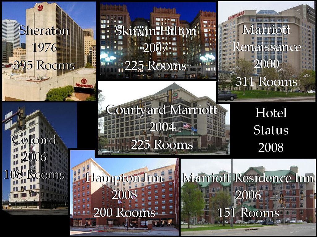
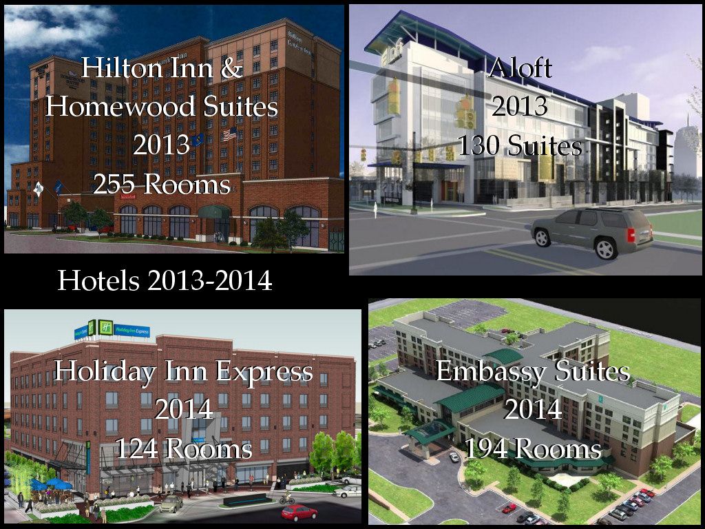
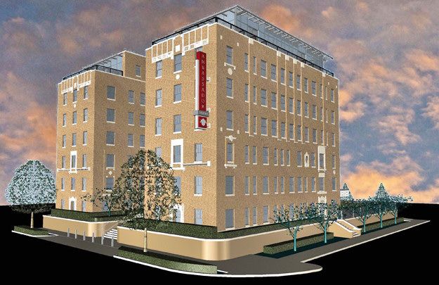 Yet another, a 54-room Midtown boutique hotel owned and being developed by Tulsa hotelier Paul Coury's company (which developed the Colcord Hotel in 2006) should be included. This outstanding project is presently converting the historic 1929 Osler physicians building at 1200 N. Walker into an Ambassador Hotel and it is scheduled for opening in December 2013. That date may be a bit ambitious — I'm guessing that an early 2014 opening is more likely.
 2007-2008: A Funny Thing Happened On the Way to
  Dark City. This was a very dark period for investigative journalism at the Oklahoman, very dark. Recall these things: the Chamber itself guided the MAPS 3 campaign; the campaign was led by David Thompson, then the Chamber President; Thompson was also president of the OPUBCO Communications Group. Thompson or his staff held close reigns on what Oklahoman reporters were allowed to write about during the MAPS 3 campaign and, on at least one occasion that I am privy to, even changed a reporter's submitted MAPS 3 story to render it more MAPS 3 friendly than the article he originally wrote for publication.