skip to main |
skip to sidebar
Updated September 2, 2009Visitors in the past 10 days or so may have noticed some changes in Doug Dawgz Blog. I've reluctantly (reluctantly, since I didn't want to break something that wasn't broken) made major internal changes to the blog by completely changing the software template which is a pretty scary thing. What if everything that has been done in the past 3-plus years suddenly gets trashed with no backup? What if you (and I) liked the old setup better than the new? What if the Pilgrims had shot cat instead of turkey ... we'd all have pussy for Thanksgiving. Pondering that last thought, and nudged on by my good friend Steve Lackmeyer who kindly informed me that it would be good for me to consider making some user-friendly changes to my blog (after which I initially told him that HIS Okc History blog was far less user-friendly than MINE), all things considered I decided to take his advice and make the precipitous plunge.
So, now, though kinks remain to be worked out, Doug Dawgz Blog is different.
HOW? Aside from some "appearance" matters, some major substantive changes have and are being made.
- Existing and future content is, I hope, not affected at all ... and that potential worried me just a little. But, all old content seems to be OK.
- Blogger template modification has made at least two things much better than they were before:
- Search. Search features are MUCH better than they were before. Try out the new "Search Doug Dawgz Blog" item in the left panel and see if you don't agree. Click here for examples of how the new search feature works.
- Truncated Articles. New articles will be split into two pieces ... an introductory/preview part generally describes the article and is followed by a "... Read The Full Article ..." link which opens the whole article.
Clicking that link opens in a separate window or tab (depending on your web browser). When finished with that newly opened article, close the page and you'll be back where you started from. All articles previously written have been modified to set them up in this fashion, and all future articles will have this method. With this change, page loading when browsing the blog should be faster and 5 abbreviated articles plus the opening index page are now visible on the same page.
- Site Feed History/Downtown Blogs. This new feature presents preview snippets of the most recent articles listed in the group. Located in the left pane, click here for more detail.
- Labels/Categories. In the new template, it is possible to show "Labels" associated with articles in the left panel and then click on a Label for a preview of all such items. All labels/categories have been revised for that purpose, and the labels are all present in the left panel.
- Older Posts. At the bottom of each "new" page, in the lower right corner, a new link is present ... "Older Posts." You can click that link to move back to the 6 previous articles that have been written. This should be handy for those who want to browse and aren't looking for anything in particular. But, those who are wanting to find something in particular should use the new Search feature in the left panel or the general Index.
I'd appreciate any feedback, good or bad, that you'd care to give.
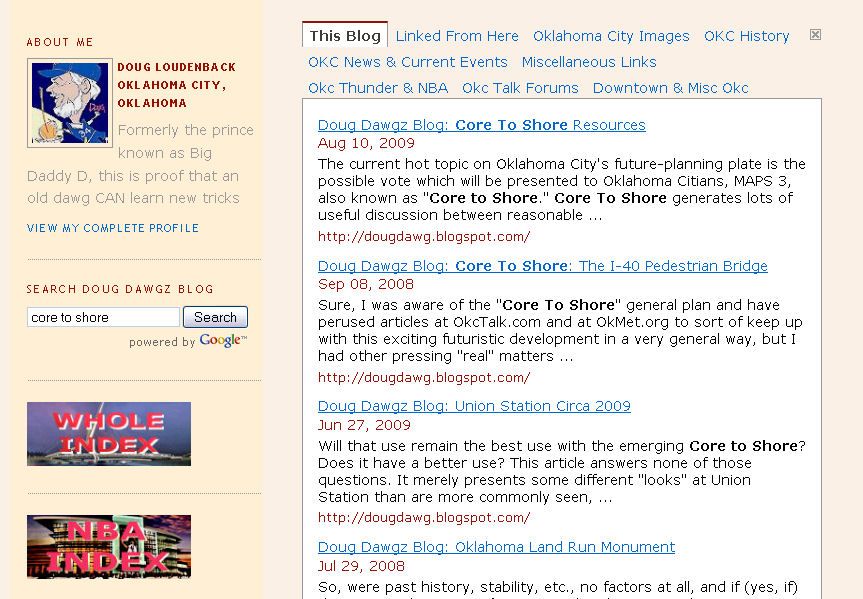
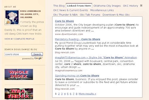
New Search Features. In its newer templates, Blogger (host of my blog, a Google component) has really spiffed up the search features in blogger. This shows two examples.
1st Example - Using Search. I want to search for "core to shore."
Search is in the left pane
 | Type in search text
 |
Search results are returned in the main pane of the page, as shown below. Click on the images for larger views.
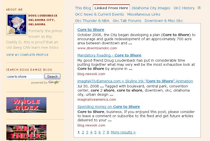
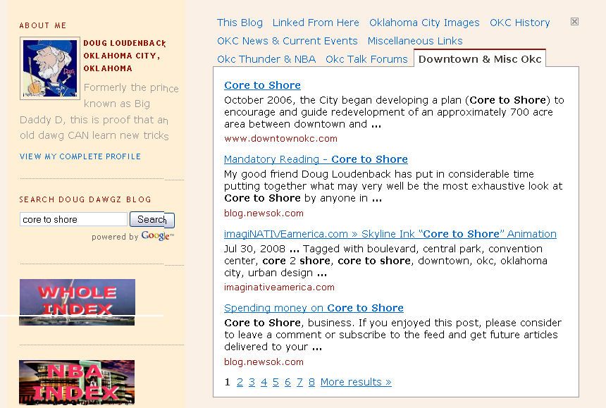
Notice the tabs at the top - the 1st tab is "This Blog."
Search results from websites listed in my left pane are also returned.
A pair of examples are shown below for 2 other tabs.
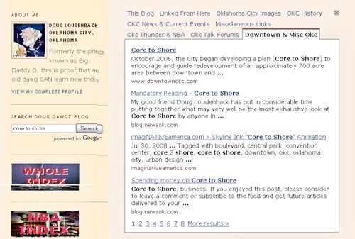
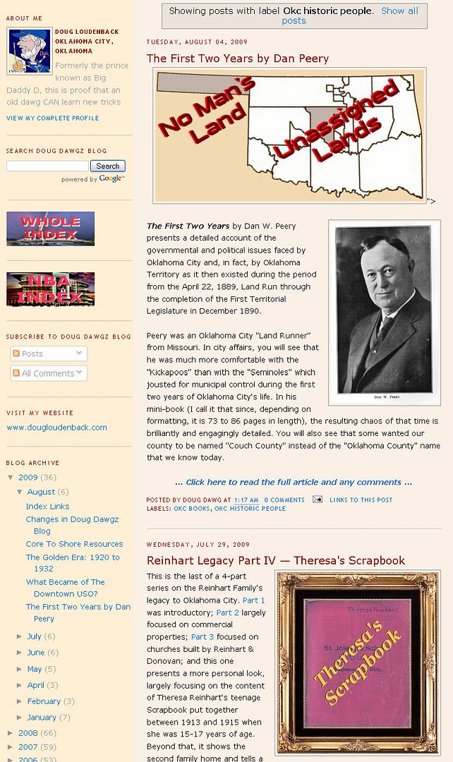
2nd Example - Using Category Search. Similarly, searching categories (Labels) that posts are organized in returns results in the main pane. In the example below, I clicked on the "OKC Historical People" label. A list of truncated articles appears.
Site Feed For History & Downtown Blogs. In the left pane near the top is a new feature which shows snippets of the most recent posts from blogs having an Oklahoma City history and/or downtown focus, as shown below:
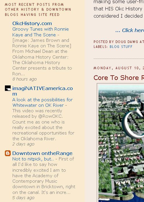
Others would have been added, e.g., OkcCentral.com, but they do not generate site feed so that the most recent post would be generated in this feature. It provides a quick way to see the most recent article written for the blogs identified.
Any comments about the above or other suggestions about improving Doug Dawgz Blog are welcome and appreciated.
... Click here to read the full article and any comments ...
Updated September 9, 2009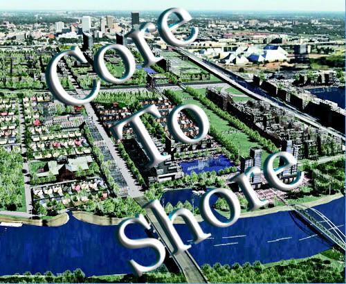
Click here to open a printer-friendly version of this file.PREFACE. The current hot topic on Oklahoma City's future-planning plate is the possible vote which will be presented to Oklahoma Citians, MAPS 3, also known as "Core to Shore." Core To Shore generates lots of useful discussion between reasonable and open-minded people; as well, it produces a lot of heat in debates between partisans who already have their minds made up about the matter (which matter, to be sure, has not yet been finalized in such a way so that verbal combatants actually have certain knowledge about the product they are either defending or criticizing). Such discussion and debate will doubtless continue until such time as the City Council should decide to put the matter to a vote of the people, probably occurring before the end of 2009 to dovetail into the time that our March 4, 2008, "Major League City" tax comes to its end. It should also be mentioned that events leading to the intervening March 4, 2008, Ford Center vote occurred after the Maps III steering committee presented its final report. That report presumed that the "next" penny sales tax vote would be on MAPS III. When providence gave Oklahoma City its opportunity to be the home of an NBA team, MAPS III was quickly moved to the back burner in deference to that opportunity and voters approved that intervening Ford Center sales tax proposal. That vote was doubtless a pivotal piece of the curious puzzle which resulted in the relocation of the team formerly known as the Sonics but now known as the Thunder from Seattle to Oklahoma City. Consequently, the dates contained in the steering committee's report described in this article necessarily require adjustment because of that intervening event. However, I have made no attempt to adjust dates contained in the committee's final report which will be described below. Dates mentioned below are those stated in the committee's report. The purpose of this article is to contribute to the discussion by assembling and presenting resources which may be useful in thinking this Core To Shore thing through and the content of this article will change as I learn more things to add.
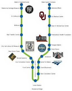
FINAL REPORT OF THE CORE TO SHORE COMMITTEE
Introduction The Committee Plan Location & Use
Three Phases Phase 3 Exclusions
What Will Be Gone In The Park Area Outside the Park Area
The Replacements Transit Other Features
INTERNET RESOURCES & DISCUSSION
Internet Resources Discussion of the Issues
Too Soon? Tax Break? Focus On Core? Light Rail First?
Need Convention Center? The Boulevard Park Size
Convention Center Location Preservation Issues
Modern Streetcars What's In It For Me?
What's the Timeline? Conclusion
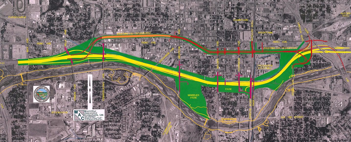
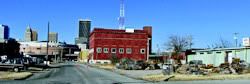
INTRODUCTION. Core To Shore is Oklahoma City's response to the Oklahoma Department of Transportation's decision to realign the I-40 Crosstown Expressway from its 1965 location which skirts the south side of downtown to a new path which more or less parallels the east/west Burlington Northern Santa Fe railroad tracks several blocks south of downtown. For more information about about ODOT's decision, see this overview at ODOT's website. Click the ODOT map below for a larger view of the I-40 realignment.
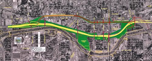
The relocated Crosstown begins at the I-235 junction and rejoins the existing I-40 at May Avenue and it is expected to be completed in 2012, three years from the time this article is written.
To mitigate the loss of I-40 passing along the south edge of downtown and providing easy interstate highway access to the city's core, a feature of ODOT's plan is to replace the existing I-40 between I-235 and May Avenue with a six-lane ground-level boulevard which passes through downtown.
Although probably originally nonplussed about the loss of instant interstate access to downtown, city leaders came to see the highway's relocation as a once in a lifetime opportunity, and the result was "Core To Shore," a plan which would enhance the city's downtown to levels not earlier possible.
In 2006 Oklahoma City established a steering committee to consider the matter and its Final Plan was completed in 2008. That plan can be downloaded from the City's Core To Shore web page here but you may find that downloading or opening is faster in the copy that is posted on my web server.NOTE: To download the file to your computer instead of "opening" it right now, RIGHT-CLICK on the last link and in the pop-up menu, select "Save Target As" or "Save Link As," depending on your web browser software. The 118 page PDF file is a very hefty 145 MB file heavily laden with graphic images and it will take a good bit of time to open or download, but if you want to look at the plan closely and whenever you want, I recommend that you download the plan to your own computer so that you can study it at your leisure. It will open much more quickly from a file stored on your computer than it will from a file stored and opened on the internet.
In that report, an introductory letter by Mayor Mick Cornett and an "Afterword" at the end present the general vision and aspirations of the committee.
Excerpts from the Mayor's November 2007 letter:
The Core to Shore Master Plan represents the culmination of our rigorous planning process, but we are at the beginning of what is a monumental opportunity for the citizenry of Oklahoma City. With the Core To Shore Framework Master Plan in hand we have a blueprint for recreating the southern entrance to our downtown benefitting its ongoing renaissance, as well as the tools for reconnecting the heart of our City to the revitalized Oklahoma River.
Afterword:
Completing this plan is the first step of the Core to Shore journey. The powerful ideas and vision of Oklahoma City’s leaders and citizens, applied and adapted over the next few decades, will guide the plan’s implementation. Core to Shore’s features – parks and public places, homes and neighborhoods, boulevard and streets, retail and office development, riverfront, pedestrian, bicycle and transit systems, landmark bridges, civic buildings, and others – have been carefully crafted to fit together and produce the urbanity, variety, and experience found in great cities. This is the kind of endeavor that changes a city’s image forever. The Core to Shore district is the common ground for all of Oklahoma City’s citizens – it is at once a place of immediacy, proximity, and walkability – and a place of comfort, magnificence, and pulsating urban life. Sandwiched between those two excerpts are about 114 pages of text and graphics which present the committee's final plan.
THE STEERING COMMITTEE'S REPORT. This section contains some, not all, of the data/information in the Steering Committee's report. For all images shown below, click on an image for a larger view.
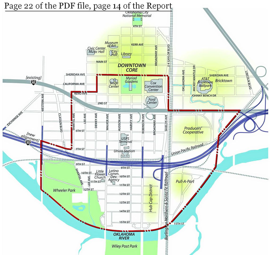
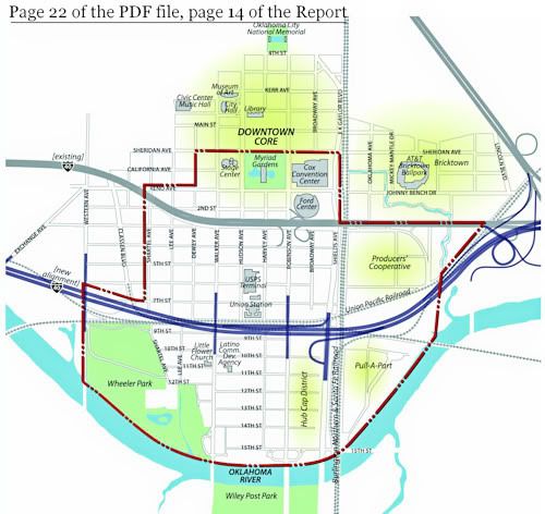
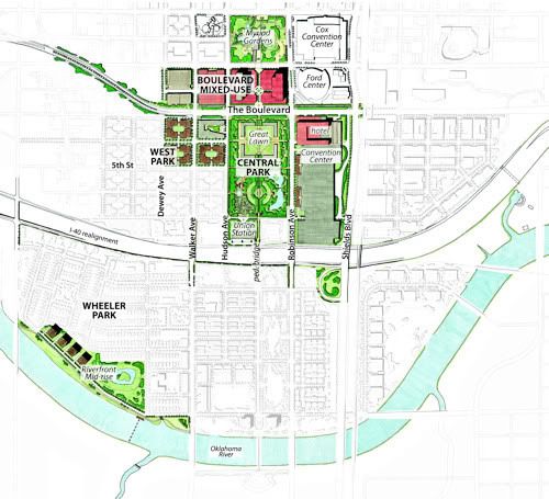
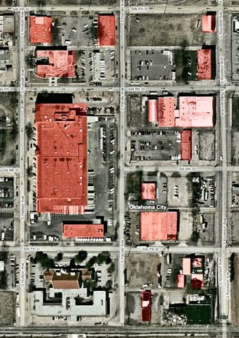
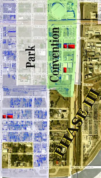
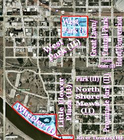
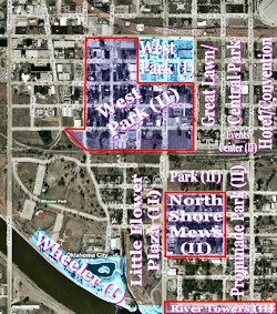
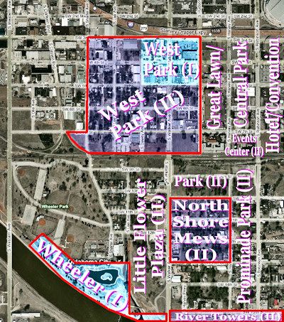
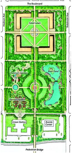
● Location & Intended Use. The map below shows Core To Shore's irregular boundaries — the red dot-dash line is the border. East/west (aside from the area above present I-40), above the Oklahoma River, the area is bordered by Shartel and the I-40/I-235 junction and below that the Oklahoma River; but below the river the border extends further west to Western. North/south, the area extends from above present I-40 down to the Oklahoma River.
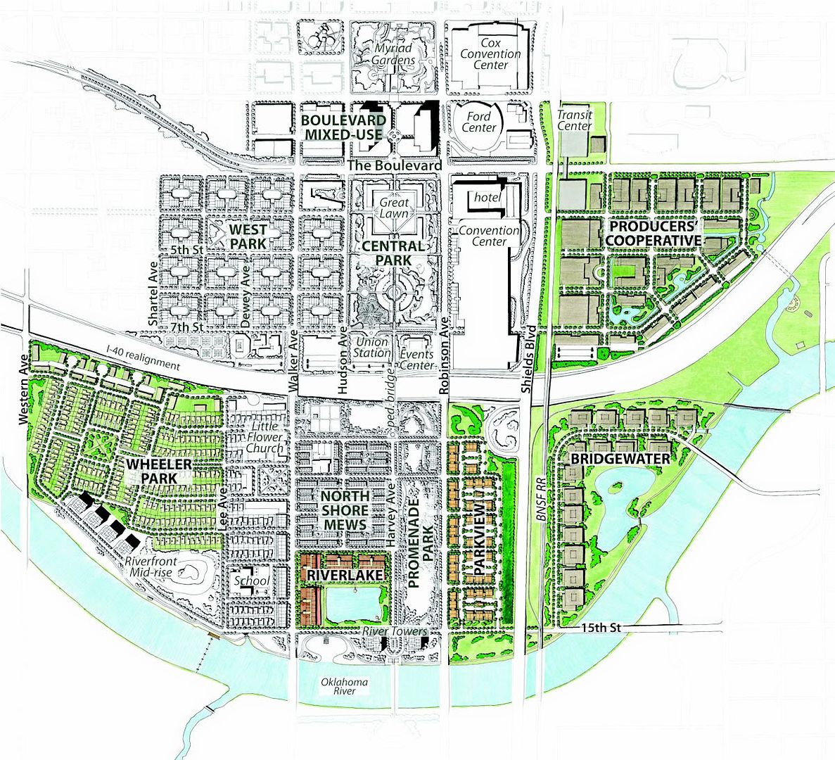
If all goes according to the current plan, by 2018 to 2020 Core To Shore will have developed and used this space as shown below.
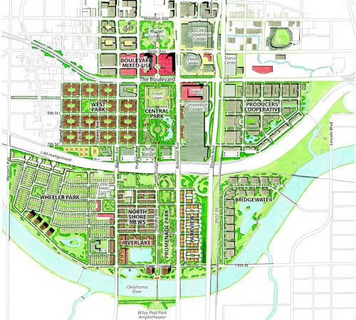
● Three Phases. According to the plan, the area will be developed in three phases: Phase I (2008 to 2014), Phase II (2012-2020), and Phase III (2018 and beyond). Phase I focuses on the area from Myriad Gardens to the Crosstown relocation and from Hudson to Robinson and also includes a bit in Wheeler Park. In this area the Myriad Gardens would be improved, a six-lane boulevard would be constructed, south of which a Great Lawn, new Convention Center & Hotel, and Central Park would be created. Phase II completes development north of I-40 and begins development of key parts of the West Park and North Shore neighborhoods and areas. Phase III completes the Wheeler Park and North Shore neighborhoods, and extends redevelopment east of the BNSF railroad corridor to include the Cotton Producers Cooperative and "Pull-A-Part" auto salvage areas also called Bridgewater as well as parts of the North Shore area not done in Phase II. Note that I'm using the start and end dates contained in the report, even though this article is written in August 2009 and those dates may require an adjustment by bumping those dates forward by two years in time.
Phase I — 2008-2014
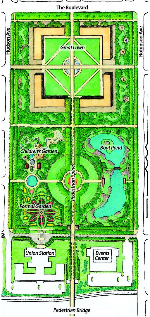
In Phase I, the boulevard and adjoining space will be developed; Myriad Gardens will be improved; south of the boulevard a convention hotel is proposed south of the Ford Center, below which a new convention center will be constructed; west of the convention hotel and convention center, a public area would be created, with the "Great Lawn" on the north and "Central Park" on the south, followed by attention to Union Station at the south end of the public area; west of this public area no the north, the initial phase of "West Park," an apartment area would become available for private development, as would a small piece of the Wheeler Park residential development located southwest of that.
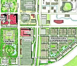
Phase II — 2012-2020
Phase II envisions completion of the West Park residential area on the west and construction of an Events Center west of Union Station; south of the relocated Crosstown, on the west, Little Flower Plaza would be developed possibly including a school/community center and perhaps a branch library; east of the Little Flower Plaza, public areas exist along the north below which is the North Shore Mews residential area, below which is the River Towers, an apartment/condo area on the north side of the Oklahoma River; east of that center area, a Prominade Park public area is shown.
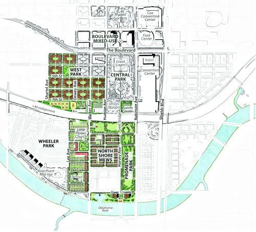
Phase III — 2018 and Beyond
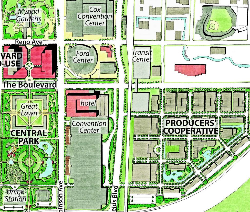
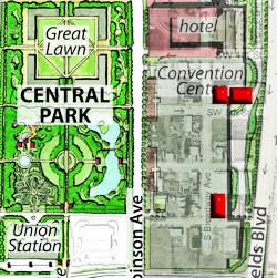
Phase III is the most speculative and will not presently be involved in any December 2009 ballot, I don't think. See the "Phase III Exclusions" discussion below which discusses the possibility of changing at least part of that so that the Oil Producer's Coop south of Bricktown would be the location of the new convention center. The committee report for Phase III development contemplates a multi-modal transit center north of the new boulevard and east of the BNSF railroad tracks at the west side of Lower Bricktown; it foresees a more complete development of the Wheeler Park residential areas, as well as other private developments on the south and east.

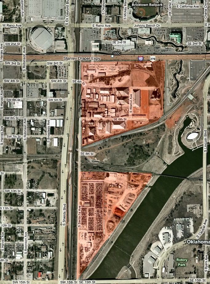
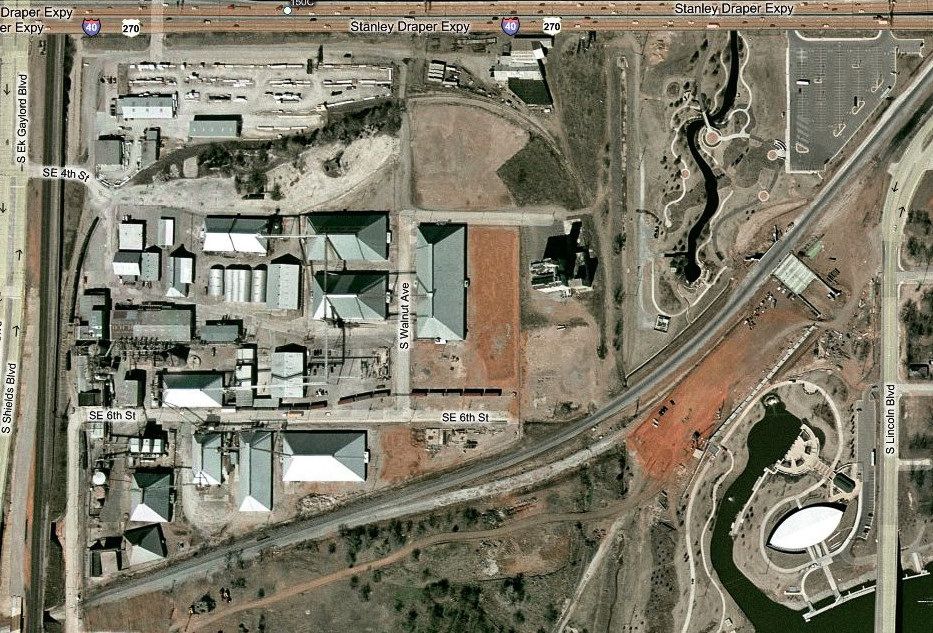
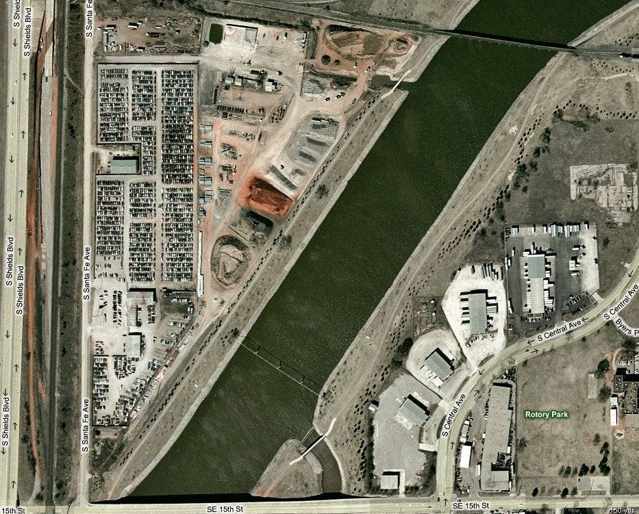
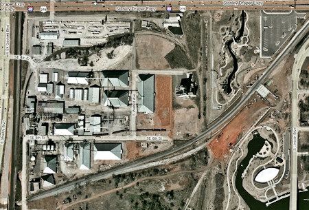
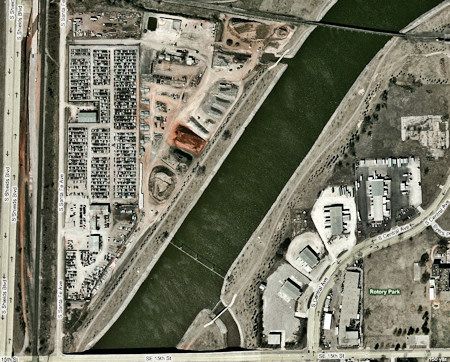
● Phase III Exclusions. Given the fluidity at the moment and likely in the future, it is significant to note here that Phase III carves out two areas from the rest and does not apparently assume to assimilate them into what would presently be acquired by the City in a possible Core To Shore ballot at the end of 2009 in which voters would say Yea or Nay — we'll have to wait to see the ballot to know for sure how those areas would be addressed. At pages 44 and 78 of the PDF file, these statements are made:
At Page 44:
The Cotton Producers Cooperative Oil Mill and a car parts storage yard currently occupy the industrial land west of Shields Boulevard. The areas will increase in value as the Core to Shore district develops. Their redevelopment will depend on future market forces. Possibilities may include business parks, sports facilities, or other special uses. Future redevelopment here will require greatly improved access.
At Page 78:
The Bridgewater site [ed note: Pull-A-Part] and the Cotton Oil Producers’ Cooperative are likely to redevelop as markets mature. Advantages of these sites include access to the freeway and the downtown core, proximity to Bricktown, and high visibility. These sites also have consolidated ownerships and enough land for large, single-purpose uses such as an office or sports campus. Projects could include special features that reinforce the patterns of adjacent development, such as extending the Bricktown Canal or creating a riverside lagoon. However, redevelopment of these sites faces significant hurdles, including relocating existing industry and providing adequate access. This is mentioned here since some, including former mayor Kirk Humphreys, have opined that it might be better to locate the proposed convention center below Bricktown instead of in the area proposed by the committee. "Below Bricktown" is the area identified in the committee report as the Cotton Oil Producers’ Cooperative, immediately south of the current I-40 Crosstown. Immediately south of that area is what is identified as the "Pull-A-Part" auto salvage area in the committee report. Both of those are apparently presently excluded areas in any Core To Shore vote that may occur in the near future (aside from possibly being included in a future Phase III public development for planning purposes). The areas are shown below.
Overview of the Combined Excluded Areas

Cotton Oil Producers’ Cooperative
The Pull-A-Part Auto Salvage Area
The Cotton Oil Producers' Coop exclusion is important IF, instead of the committee's view, the new convention center should be located south of Bricktown and not south of the Ford Center which the committee recommends. If the eventual plan is intends to include those areas in Core To Shore, when would it be less expensive for the City to acquire them, now or later? See the Discussion section of this article for more.
WHAT WILL BE DESTROYED UNDER CORE TO SHORE. When the Pei Plan was adopted in the 1960s, it seems reasonable to say, in hindsight, that not enough value was placed on preserving Oklahoma City history in the approach taken: (1) "If we do this, what will we lose?" and (2), "Do we care?"
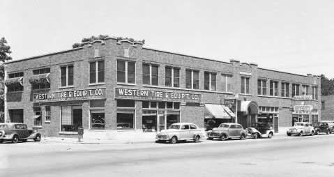
As a result, about 40% of downtown Oklahoma City was lost for all time. The list of destroyed historic buildings in that period is mind-boggling — it includes every downtown movie theater except the Centre, the Baum, Commerce Exchange, Biltmore, Huckins, Wells-Roberts, Oklahoma Club (Tivoli Inn) and other hotels, just to name a few of the downtown buildings forever lost by decisions made in the Pei Plan/Urban Renewal era.
BEFORE we might vote to add a second chapter in the book named Downtown Oklahoma City Destroyed, a review of the buildings which will be lost and destroyed in the present Core To Shore plan seems an appropriate thing to do, and this is it.
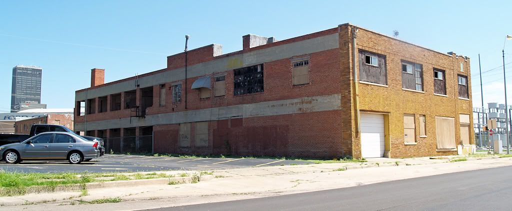
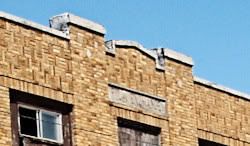
In the committee's final plan at page 30 of the PDF file, some homage is given to historical issues. Judge for yourself how much.BUILDINGS AND HISTORIC SIGNIFICANCE
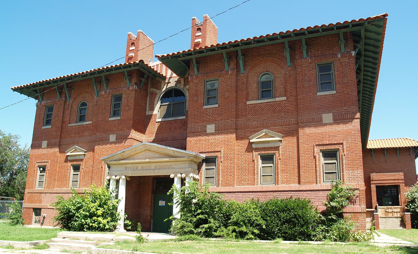
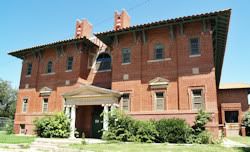
The Core to Shore district’s building stock is a mixture of industrial buildings, brick warehouse structures, storage yards, and older residential structures interspersed with vacant land. Many structures are in poor condition. Two buildings in the district, Union Station and Little Flower Church, have special historical and architectural significance.
Union Station, opened in 1931 and listed on the National Register of Historic Places, is located directly south of the US Postal Service building that blocks a clear view of its historic, Mission Revival facade. The former depot currently houses the Central Oklahoma Transportation and Parking Authority (COTPA) and a small business, but it is not used for public events. Little Flower Church, at 1125 South Walker Avenue, was established in 1926 to serve the large Mexican immigrant community that lived in the Riverside neighborhood at the time.
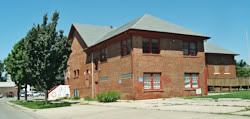
While no other buildings have the architectural significance of Little Flower Church and Union Station, several notable older buildings, such as the Latino Community Development Agency building, contribute to the character of the area and could be incorporated into development projects if economically feasible. The report does not otherwise identify what (if anything in particular) may have been meant by the phrase, "several notable older buildings" other than Riverside School & the old church (which are the Latino, etc., buildings).
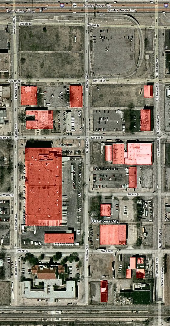
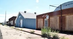
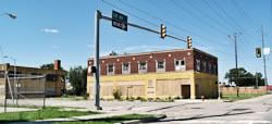
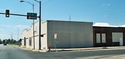
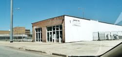
The images below show two groups of endangered buildings, (1) those within the proposed convention center and hotel, the Great Lawn, and Central Park; (2) those outside that area which are also included in Phase I or II.
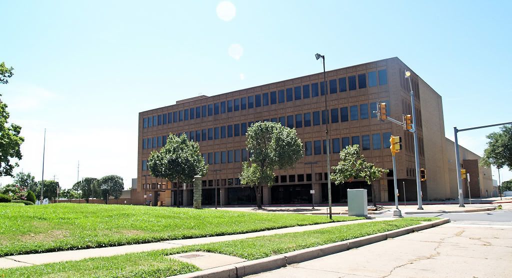
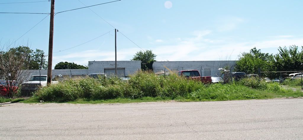
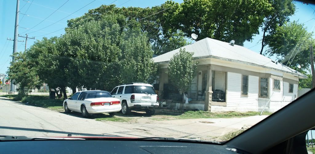
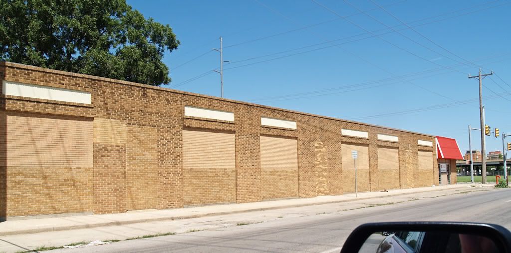
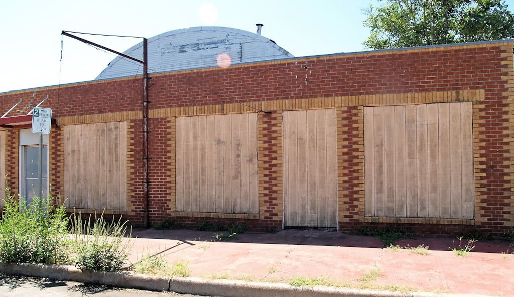
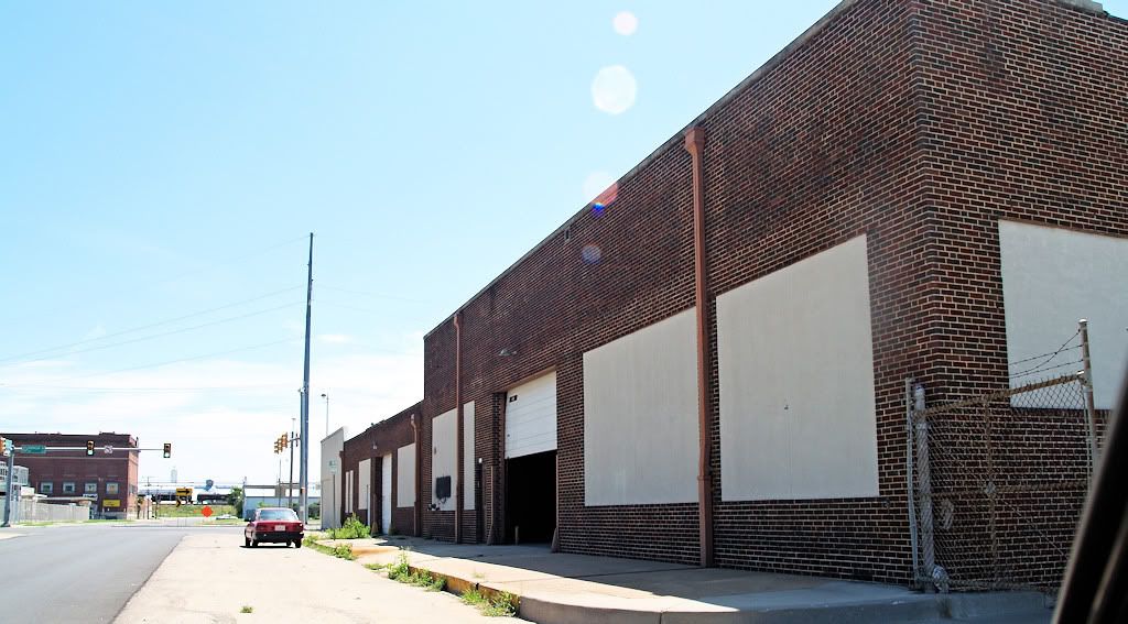
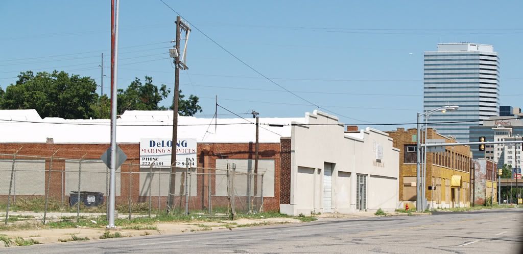
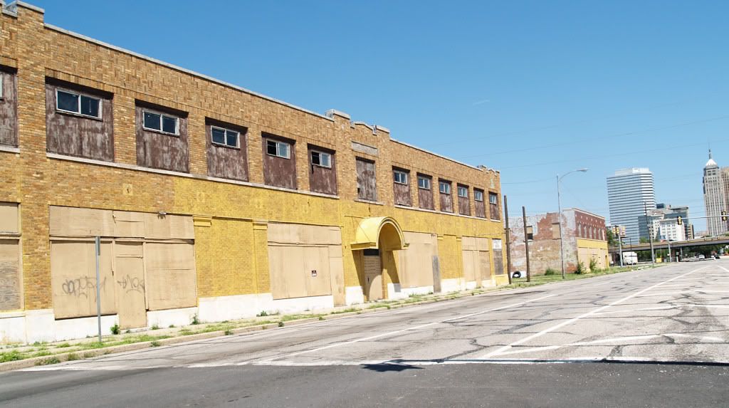
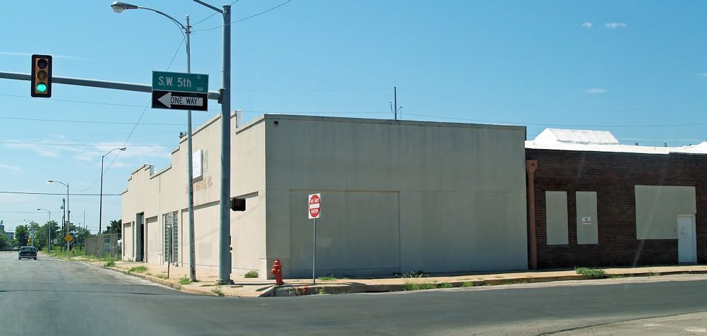
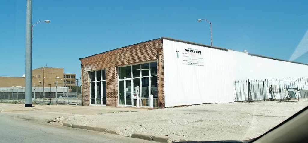
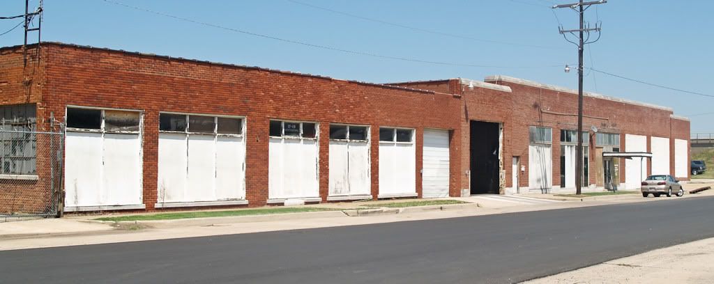
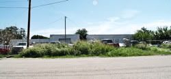
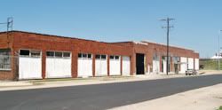
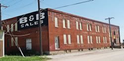
● The Park Area South of I-40. Phase I calls for (among other things) a Great Lawn and Central Park to be developed south of current I-40 and down to the BNSF railroad. Only the venerable Union Station is excluded from demolition in this area.
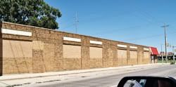
 Here are buildings which would be destroyed in this area. Click on the thumbnail images for larger views. Here are buildings which would be destroyed in this area. Click on the thumbnail images for larger views.
Salvation Army - SW 4th & Harvey
 | Salvation Army - SW 5th & Harvey
 | Post Office Buildings
 | East of Union Station - SW 7th
 | Small House on SW 7th
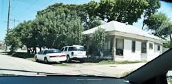 | Building on Harvey & SW 4th
 | On SW 5th Looking South
 | On SW 5th Looking ESE
 | On SW 5th Looking ENE
 | On SW 5th looking East
 | On SW 5th Looking ENE
 | On Robinson Approaching SW 5th
 | On Robinson — Film Exchange
 | Showing Film Exchange
 | On Robinson N of Film Exchange
 | On Robinson & SW 5th Looking South
 | On SW 6th east of Post Office
 | On SW 6th Looking South
 |
It is your task and mine as a contributor to the Core To Shore discussion and ultimately as a voter to decide whether any or none of the above buildings are worth preserving.
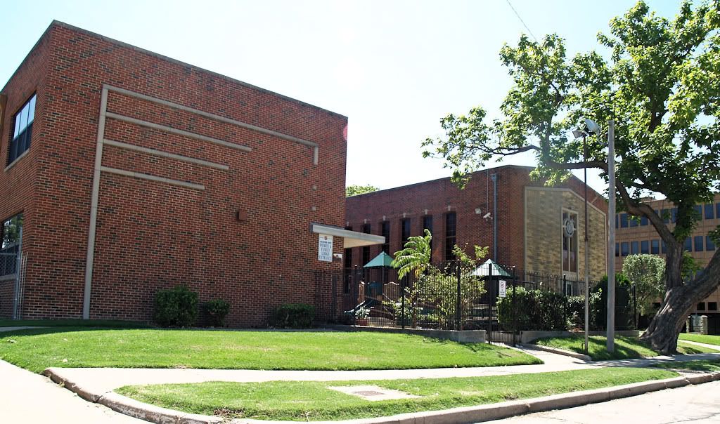
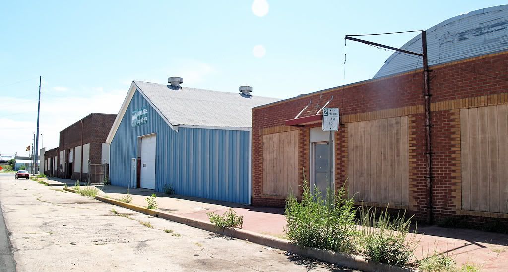
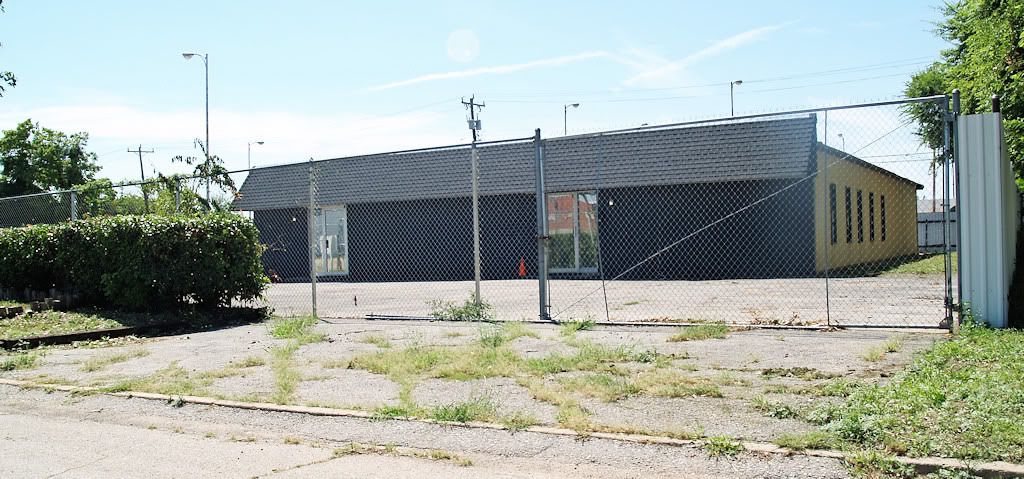
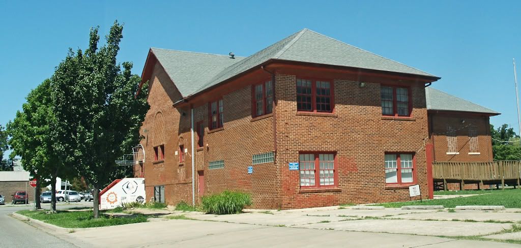
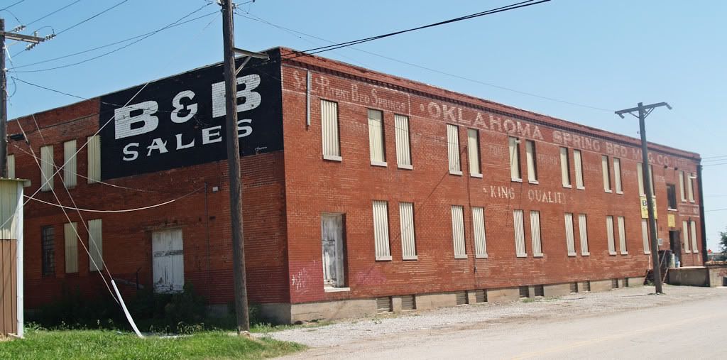
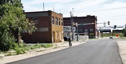
● Outside the Park Area. Phase I area identifies by omission a few notable buildings east of the park area in convention center/hotel area would presumably be demolished. Southwest of the park area, only a pair of buildings serving the Latino community which are in Phase II (Riverside School and its next-door church) are mentioned in the committee report as possible exceptions to demolition. Those buildings and three others in the convention center/hotel area are shown below.
| The buildings below on SW 11th were mentioned as possible exceptions. | Riverside School
 | Old Church - SW 11th & Walker
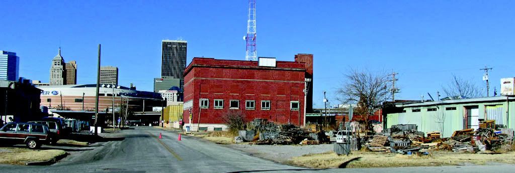
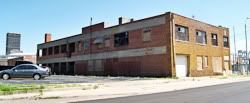
 | | Buildings below are east of the park area on or off-Broadway are not specifically mentioned in the committee report although the 1st, the 1909 International Harvester building at SW 5th & Broadway, is identified by a graphic. | International Harvester
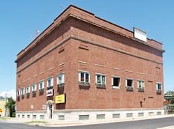 |
The Committee Report's View
Of This Building
 | | Other South Broadway Buildings At Risk | East of Intl. Harvester On SW 5th
 | SW 7th & Broadway
 |
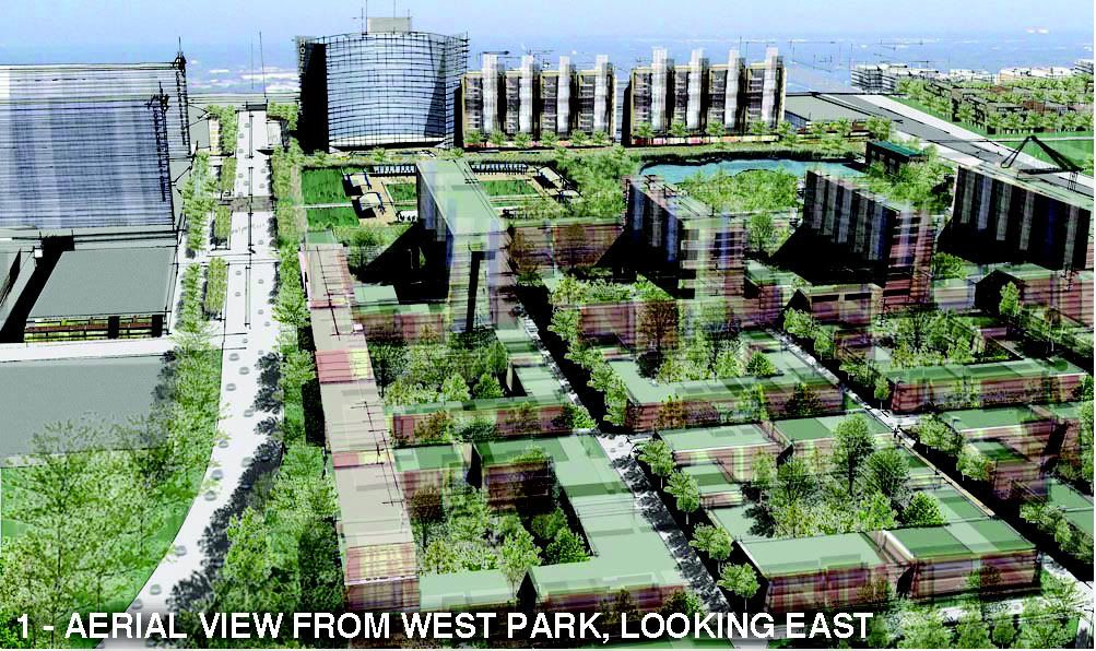
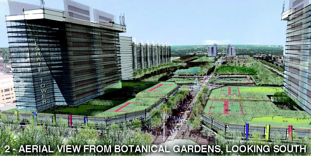
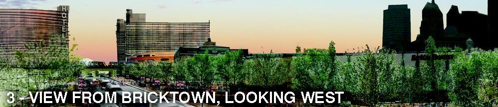
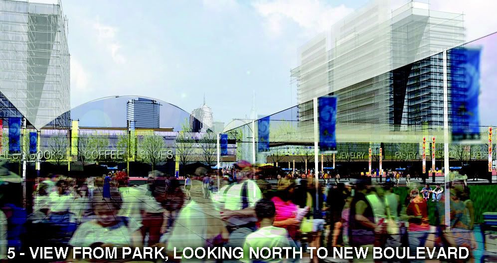
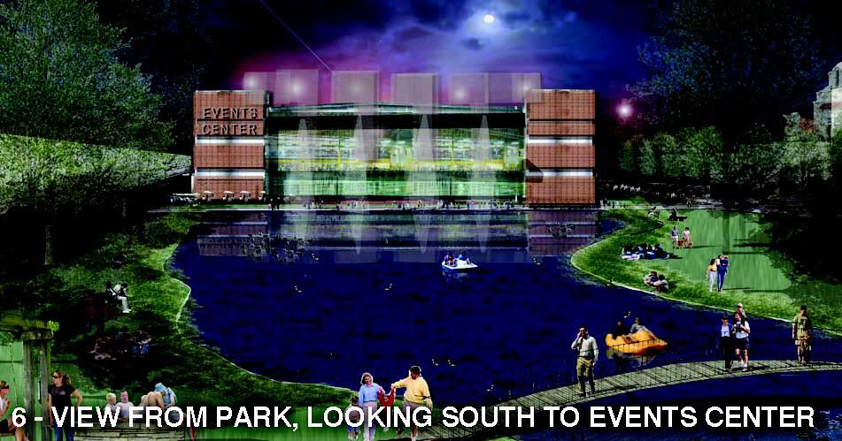
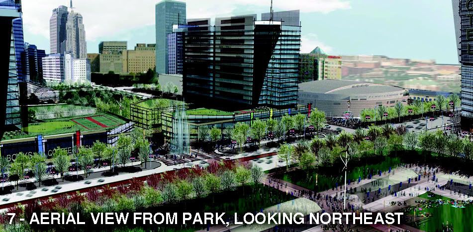
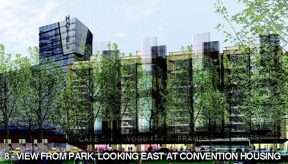
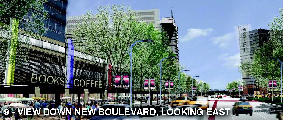
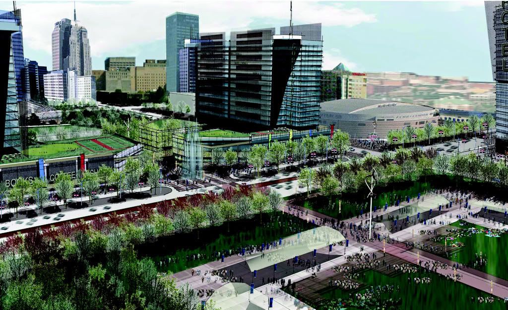
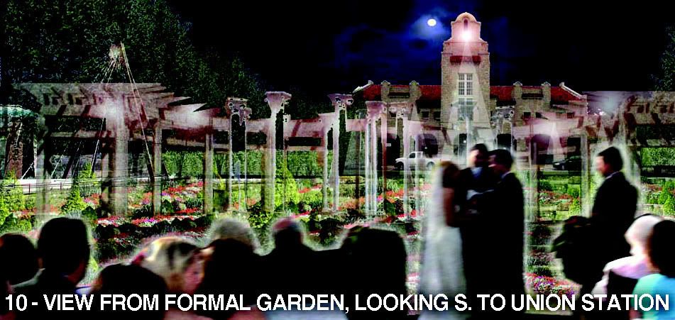
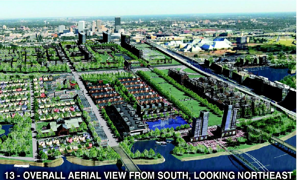
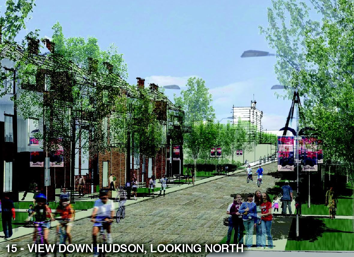
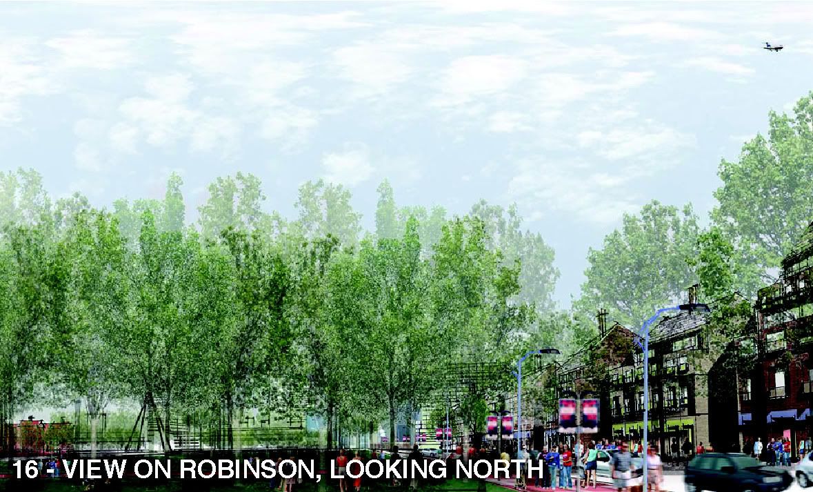
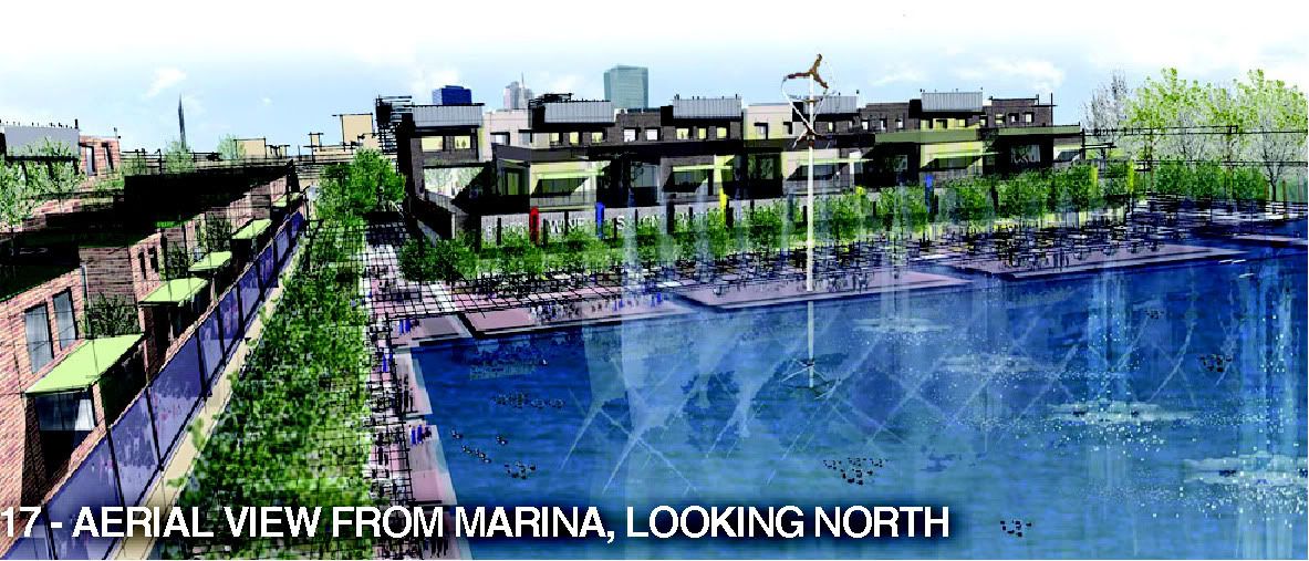
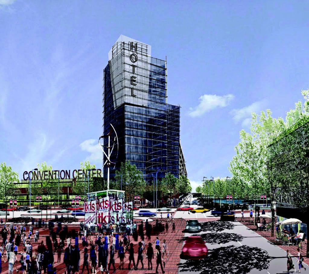
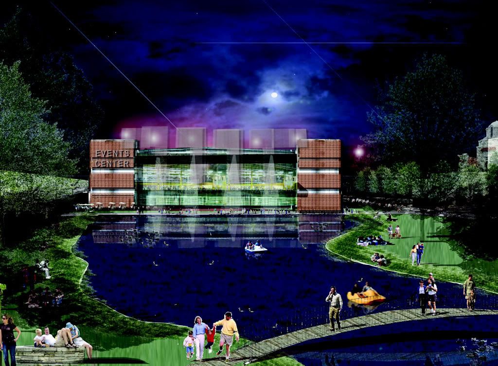
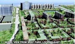
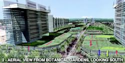
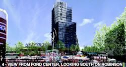
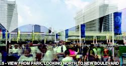
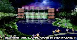
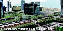
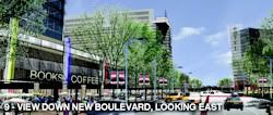
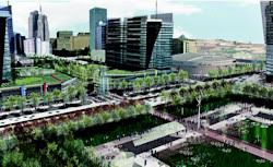
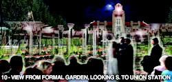
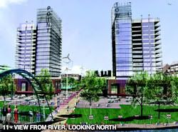
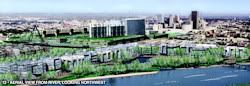
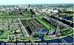
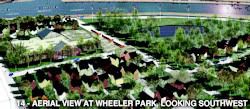
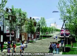
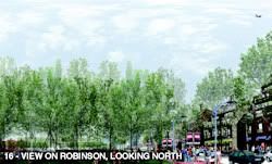
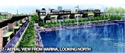
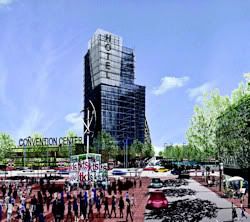
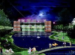
THE REPLACEMENTS. The committee report contains many stunning images of what would replace old lamps for new. Some but not all are shown below. Click thumbnails for larger views.
From West Park Looking East
 | From Myriad Gardens Looking South
 | From Bricktown Looking West
 | From Ford Center Looking South
 | From Park Looking North
 | From Park Looking South
 | From Park Looking Northeast
 | From Park Looking East
 | On New Boulevard Looking East
 | Boulevard Looking Northeast
 | From Formal Garden Looking South
 | From River Looking North
 | From River Looking Northwest
 | From South Looking Northeast
 | Wheeler Park Looking Southwest
 | On Hudson Looking North
 | On Robinson Looking North
 | From Marina Looking North
 | Hotel At Convention Center
 | Events Center
 |
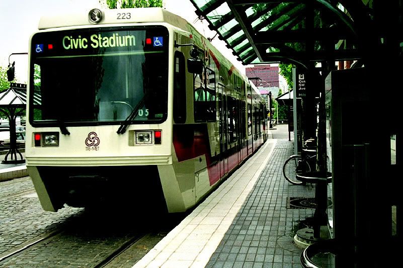
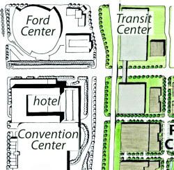 TRANSIT. The report discusses some present and future transit issues but not in the sense of any large-scale light rail system. The report does contemplate the possibility of a multi-modal transit system facility shown in the Phase III location to the right. At PDF page 74, report page 66, the report reads: TRANSIT. The report discusses some present and future transit issues but not in the sense of any large-scale light rail system. The report does contemplate the possibility of a multi-modal transit system facility shown in the Phase III location to the right. At PDF page 74, report page 66, the report reads:
TRANSIT CENTER
Transit has a key future role in the city’s transportation system. Serious consideration of implementing a multimodal transit system began with the publication of the Fixed Guideway Study in 2006, and a follow-up study is now considering alternative approaches. As support for transit and its role in the city environment grows, the possibility increases that such a system will develop within the Core to Shore development timeframe. Walking and bicycling are fundamental parts of the Core to Shore concept. A transit center would serve all potential public transportation modes, including local circulators, city and intercity bus service, fixed guideway transit, and commuter and intercity rail passenger service. While the feasibility and location of such a site requires additional study, the Core to Shore Plan proposes a location along the northsouth BNSF line as best able to serve all potential modes. Key site criteria include a minimum two square block area, easy access to the interstate highway system, and adjacency to existing and potential passenger rail lines. The facility would include elevated rail platforms, surface and structured parking, transit transfer capabilities for both bus and fixed guideway transit, and supporting retail and other commercial services. 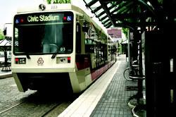 But, the above wouldn't be included in any December 2009 vote. That part comes in at PDF page 93, report page 85, the report shows the graphic at the right together with the caption, "Convenient, attractive public transit is necessary for the success of the Core to Shore district." The report reads as follows: But, the above wouldn't be included in any December 2009 vote. That part comes in at PDF page 93, report page 85, the report shows the graphic at the right together with the caption, "Convenient, attractive public transit is necessary for the success of the Core to Shore district." The report reads as follows:
PUBLIC TRANSIT
Convenient, frequent, and reliable pubic transportation strongly reinforces pedestrian activity. The Core to Shore district's proximity to other downtown districts, the medical campus, and the capitol complex makes it especially suited to public transit services. At the time of this writing, COTPA, Oklahoma City's transit authority, is conducting an alternatives analysis for a downtown circulator. Criteria for an effective system that would promote both transit access and Core to Shore development include
- A bi-directional loop operating along Robinson and Walker Avenues from the downtown core to the Oklahoma River, with extensions to the south as development continues
- Distinctive vehicles that combine functional design and a strongly positive transit image
- Low-floor vehicles with multiple doors, substantial standing room, and transverse seating to speed loading and unloading, and make transit accessible to people with disabilities
- Distinctive and attractive transit stops at appropriate spacing, providing information on routes, times, and arrival of the next vehicle
- Free fares to encourage ridership and expedite trips.
In addition to the circulator, the district's adjacency to the proposed transit center will facilitate travel to and from other parts of Oklahoma City. Boiling the above down to a few words and given the graphic used in this section, fixed rail vehicles would be on a bi-directional loop along Walker to Robinson from "the downtown core" (whatever that means) to the Oklahoma River and the cost would be free. These vehicles are referred to as "modern streetcars" in the Discussion area below.
OTHER FEATURES. I'll close this out by mentioning a couple of other features contemplated in the plan. During Phase II and/or III, a school/community center and library are proposed to be located in the southwest areas of the plan. And, more generally, the value of public art is emphasized several times throughout the report.
● School/Community Center & Library. PDF page 68, report page 60, a branch public library is contemplated in the Little Flower Plaza area. The text reads,
Little Flower Plaza Little Flower Church is a spiritual symbol of the vital contribution of Latinos to the life and culture of Oklahoma City. The proposed Little Flower Plaza, adjacent to Walker Avenue, reflects the nature of the traditional Latin-American town square, flanked by the church on the north and retail shops to the south and west. The retail edge will include a neighborhood library. At PDF page 77, report page 69, the report says,
Urban School The projected Core to Shore district’s population is large enough to create a demand for a new elementary school. In addition, an innovative or magnet school may add secondary education. A potential school site on a block at SW 14th Street and Walker Avenue is easy to reach by car and will also encourage parents and children to walk and bicycle to school. This site has the added advantage of easy access to the wetland based park to the west. Because of the abundance of amenities in the Core to Shore area, a school could be placed in several different locations and still offer a range of benefits not available to many suburban schools. Access to various cultural facilities and the river would be just two examples. The new urban school should be a true community learning center, offering afterschool programs, and night and week-end classes.  ● Public Art. In numerous locations, the report emphasizes the value of public art throughout the Core To Shore public areas. Although it notes that such art is often the result of philanthropic contrition, the report also contemplates some public funding. A beautiful example is shown at page 69 of Ft. Worth's Bass Performance Hall, at right. At PDF pages 68-69, report pages 60-61, the report states: ● Public Art. In numerous locations, the report emphasizes the value of public art throughout the Core To Shore public areas. Although it notes that such art is often the result of philanthropic contrition, the report also contemplates some public funding. A beautiful example is shown at page 69 of Ft. Worth's Bass Performance Hall, at right. At PDF pages 68-69, report pages 60-61, the report states:
PUBLIC ART
Public art is integral to the Core to Shore district and should pervade its parks and open spaces, making the district an outdoor gallery. It can also create identity and distinction for private development. Oklahoma City has a strong tradition of investments in the arts. The Oklahoma Land Run monument by Paul Moore, south of Bricktown, and Alan Houser’s sculpture As Long as the Waters Flow near the capital building both capture local history and create landmarks. The Oklahoma Museum of Art is a popular downtown attraction with regular temporary exhibits and a nationally recognized permanent collection of artwork by Dale Chihuly. Public art may include individual installations or be incorporated into functional elements (such as benches, lighting, and paving) of the new boulevard, parks, sidewalks, and private and civic developments. Oklahoma City should consider including funding for public art in the Core to Shore Projects The City has a policy for art in public places that allows one percent of a project’s cost to be set aside for works of public art. While the City may choose not to include one percent of art for some public projects, this provision was used during MAPS to include works of art in each of the projects. In Denver, private developments benefiting from tax increment financing must include public art installations equivalent to at least one percent of the project cost. This has produced a rich and varied public art collection that includes streetscape art, mosaics, sculpture, and paintings. Although the 118 page report contains other information, the above should paint the picture reasonably well.
INTERNET RESOURCES, PUBLIC EVALUATION AND INPUT. As yet, the Oklahoma City Council has taken no action on the committee's report and citizens are led to believe that they have a role to play in shaping what the Council may ultimately choose to do. Plus, our individual decisions as voters will be our ultimate input, and hopefully this lengthy article will provide some responsible and reasonable resources in both regards.
In addition to City Hall's Core To Shore web pages, there are others.
- Steve Lackmeyer's OkcCentral blog. Of the internet resources available, I regard this resource as being well above the others that are available. Steve is co-author of the excellent OKC: 2nd Time Around in which he and Jack Money trace the history of the city from the late 1950s through 2007. The book largely focuses on downtown beginning with the malaise which set it when suburban shopping centers diminished downtown's vitality through the time that MAPS I was adopted and its aftermath. In his OkcCentral blog, Steve not only presents his own view from time to time but he has also solicited articles from various individuals in the city to speak their piece, as well. Unfortunately, articles about Core To Shore are not collected in a single place and one must ferret through blog postings to find them all which takes a fair measure of diligence. However, I'll do that for him here ... here are direct links to the more significant postings on this topic thus far: Item 1: Steve announces that he has invited others to submit articles of their vision of Oklahoma City in the year 2020 and how to get there; Item 2: Casey Cornett's article; Item 3: Dennis Wells' take; Item 4: Bert Belanger's views; Item 5: Steve considers the saving of old structures in Core To Shore's path; and Item 6: 2nd verse of Item 5; Item 7: Jim Stafford's take is that light rail should be our first priority; Item 8: My own point of view through the looking-glass backward. Other articles in Steve's blog are anticipated and I'll amend this group as appropriate.
Updating: Steve has mended his ways. To see all of his articles in a single pass, click on the category "Core to Shore" at the bottom of any of his Core To Shore posts. Good boy, my friend Steve!
- The Journal Record. Although the Journal Record's articles typically require subscription, several of its Core To Shore articles do not. Its general Core To Shore page is here. At the top of the entry page is a link to a Core To Shore video put together by the Journal Record and we are told to click a link to watch it but it isn't that easy. The problem is that if one does that one must fish back through their video pages to find it. Try this link, instead. In that 14 minute video, Mayor Mick Cornett, City Planner Russell Claus, Anthony McDermid of TAP Architecture and Michael Laird of Crowe & Dunlevy discuss the vision, concepts and hopes that drove city planners in coming up with what is in the ambitious Core To Shore plan contained in the committee report. Aside from the video, regular web page articles are more readily accessed: Item 1: Mapping Core To Shore by Brian Brus; Item 2: Central Park area Integral to Core To Shore Project by Marie Price; Item 3: Core To Shore: What's There Now by Kelley Chambers; and Item 4: Core To Shore: New developments Expected To Sprout Up by Kelley Chambers.
- OKGazette.com. The Gazette has produced a few articles worth reading about MAPS III: Item 1: MAPS 3 could bring massive central park to OKC Downtown area by Grant Slater; Item 2: Mayor prioritizes modern streetcar in OKC for MAPS 3 by Ben Fenwick and Rob Collins; Item 3: Some OKC entities stand to benefit in a MAPS 3 proposal by Scott Cooper; and Item 4: MAPS in perspective by Bill Bleakley.
- OkcTalk.com. This popular Oklahoma City on-line forum talks about just about everything Oklahoma City, and it can get downright rowdy and rude as well as wildly off-topic. That said, if you can put up with what I've just said, this thread contains quite a lengthy discussion of lots of folk talking about Core to Shore and their various views on various elements of the same. Here's another. Don't look for scholarly discussion like in the articles in Steve's blog, but ideas and insights are nonetheless there to be had.
- Nick Roberts. Nick (aka Spartan) is young and sometimes writes that way — he cannot be faulted for lacking self-confidence and/or zeal — and he is very interested in Oklahoma City, thinks about it a lot, and he is active in those regards. In his blog, he's posted three articles worth looking at on the Core To Shore topic: here, here, and here and doubtless he'll have more to say. Updating, Nick has now added a 4th, his letter to the editor.
- Blair Humphreys. As far as I'm aware, Blair hasn't chimed in on MAPS 3, generally, but I hope that he will. He has posted on the possibility of a Bricktown Canal extension being included in MAPS 3, and it is worthwhile reading.
- Marc Weinmeister. Edmond/Oklahoma City commercial real estate broker Marc Weinmeister has assembled and is assembling an analysis of Core to Shore from a financial point of view — how much money will be needed to be spent for public and private development shown in the committee's graphics to come true? To see his detailed analysis, go here.
Probably, there are others that I've missed and I'll add them as time goes on. Also, see Discussion, below.
DISCUSSION. Assuming that you might have input to make before Core To Shore is finalized and is put to a vote, or how you might chose to vote if and when a vote is set, this area is for discussion of those questions and if a reader of this article cares to comment, feel free.
Some of the questions and/or issues being discussed (see Public Evaluation & Input, above) are the following:
- Is this the right time for Core To Shore? This, like all the other questions, is a toughie, and the answer one might arrive at involves answering sub-questions, some of which are:
a. Might it be good to put down the penny sales tax for at least awhile and take a break? Since the original December 1993 MAPS 5-year sales tax, Oklahoma City has (1) voted to extend the that tax by 6 months so that the Ford Center could be constructed which was planned for but not funded during the initial 5-year tax, (2) approved the 7-year MAPS For Kids which continued the penny sales tax and, (3), most recently, approved a continuation of the penny tax for 15 additional months to improve the Ford Center and build a practice facility for the hoped for NBA team. Some might say, "Isn't 13 years and 9 months long enough for a temporary tax to last, particularly since it was only supposed to last 5 years in the first place?"
Those holding a different view than the above would likely maintain that it is apparent that the sales tax method of financing particular capital improvement projects has worked quite well for the city and its inhabitants, and that if a present unfunded capital improvement need exists, ample reason exists for the penny sales tax to be extended to pay for those needed improvements. For those having such a view, the real question for them is whether such a need presently exists. For them, the questions would likely be (1) does the city actually have a need for the improvements which are proposed and/or (2) are other capital improvement needs greater than those contained in the plan, such as those stated below. For them, the issue may not be whether the tax should be extended but for what.
b. Might it be good to defer and/or temper Core To Shore with more focus on developing existing elements of the city's core which still need development and/or maturing? Some opine that Bricktown, Midtown, Automobile Alley, the Triangle area need more time to flush out and mature and that encouraging private development, particularly residential, in Phase I and then in Phase II, would make it more difficult for that core development to occur and/or mature.
As for residential development, Phase I contains the first element of the West Park and Wheeler Park residential areas. Phase II substantially expands West Park and, in the area generally referred to as the "North Shore Neighborhood" adds the North Shore Mews (townhouses) and River Towers areas (high rise apartments or condos) as shown below — click on the maps for larger views.
Phase I Residential
 | Phase II Residential
 |
Phase I & II Residential Combined
At page 45 of the PDF file, page 37 of the committee report, West Park is described as follows:
WEST PARK NEIGHBORHOOD
Neighborhoods flanking Central Park will benefit from their easy walking distance to employment, recreation, and a growing number of downtown amenities. The West Park Neighborhood, south of the new boulevard and west of Central Park, could accommodate approximately 1,400 households. Adjacency to the downtown core and Central Park will encourage early development of West Park. A one-block square neighborhood green will serve the area. Residential towers along the west wall of the convention center will take advantage of park views and activate the center’s street frontage. Other items in the report describe the other residential areas initially mentioned.
Will such residential development impact existing budding developments in the Triangle area?
The article by Dennis Wells notes that,
There are certain components of the Core to Shore vision that should happen now, but opening large new parcels for development will absorb projects and stunt the growth of all the other rim districts including Bricktown. The existing CBD and adjacent districts need more time to mature and "finish out." There are too many gaps in the existing downtown that need to be filled with housing and other good urban architecture. Subsequently, Mr. Wells tempered his initial thoughts, however, by saying as a comment in this 2020 post,
My fears of core-to-shore sucking the development air from the blossoming rim districts was based on the master plan being implemented in one fell swoop, which it won’t. A modest phase-1 (Boulevard, Convention Center, Transit, & Park) is little more than triage for transplanting I-40, and must happen for wound management. This modest phase-1 will notify the world that OKC is serious about the future, and will probably cause increased (not decreased) development in all the rim districts. Among many other things, Bert Belanger says,
Plan for Core to Shore through a broader 20 year long process and horizon, led and participated in by more than a couple dozen people, incrementally stopping and adjusting every 3-5 years to review how the market is responding. Mix in Social Initiatives like the Jail (on a more modest, phased basis, not as a response to another unfunded Federal mandate) and Homeless Center with the sexy stuff so that voter fatigue doesn't kill the Goose that Laid the MAPs Eggs. * * * Do not try to Force the Core to Shore - it is my sense that a relatively small group of parties are unduly influencing priorities. I am okay with the MAPs 3 Convention Center idea just south of the Ford Center, but it is still a long ways to the South shoreline. Our version of Millennium Park will have to be birthed and season for 10 years before development happens naturally further South. The thing that could change this is if a huge User shows up, but none are on the horizon that I can see. Blogger Nick Roberts' Letter To The Editor is less specific but he does say, "MAPS 3 should address downtown's crippling infrastructure needs first and foremost and provide a lynchpin for achieving a critical mass of development." In his other articles, however, Nick appears to be more concerned about the overall layout than he is with the general concept of Core To Shore itself. See his other articles in Public Evaluation & Input for more about that.
In any event, what these gentlemen have to say does give a reasonable basis to step back and ponder their thoughts as Core To Shore is being considered.
c. Might it be better to invest in a large-scale light rail system first? So says guest blogger Jim Stafford at OkcCentral. He concludes his brief article with the following:I’m intrigued by the city’s Core-to-Shore plans, but know that we need to iron out the future of our intracity transportation first. Let’s hope that I’m not out here alone on an island shouting into the wind and that the rest of Oklahoma City will support a public transportation plan that includes rail as a key factor. Several comments following his article show that he is not alone in that view. In fact, a completely unscientific internet survey by the City indicated that by far the greatest number of responders favoring a MAPS III initiative also favored that "Transit (light rail, streetcars, etc.)" be the thrust of such a proposal.
In looking around the internet for more resources about light rail generally, and Oklahoma City particularly, I didn't find much useful information aside from opinion pieces pro and con on the topic of the value of light rail in which people who already had their minds made up stated their adversarial positions. That's not the type of information that I was looking for. At this point, at least, I'm more interested in genuine discussion than I am adversarial debate.
Since the cost of a light system has been said by some to be much greater than what MAPS III could reasonably fund, I was interested in finding objective information about cost one way or the other. A couple of comments following Mr. Stafford's article pointed to the cost of Austin's light rail system, but I was not able to locate verifiable information about the cost of Austin's light rail system even though I earnestly looked. Should objective first hand data be located, I'll amend this paragraph.
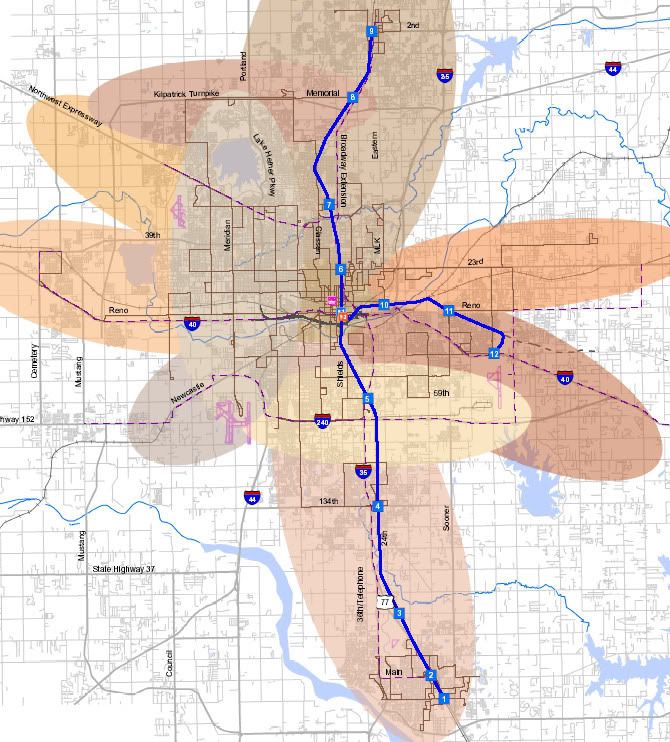
Of course, the mileage of any proposed commuter light rail transit has a great deal to do with its potential cost. On this matter, I did locate one local source, a Central Oklahoma Fixed Guideway Study which studied multi-modal transportation into the 2020s and beyond. Performed by COTPA at the behest of the Association of Central Oklahoma Governments (ACOG) during June 2004 to December 2005, it covered various forms of transit in the ACOG area shown below. The commuter rail component of the study showed three spokes converging at a multi-modal transportation center on the east side of downtown: Edmond to OKC, OKC to Norman, and OKC to Midwest City/Tinker AFB. The report did not recommend light rail from either downtown to Will Rogers Airport or any west-side light rail anywhere. In the right image, the "blue" path shows proposed commuter rail.
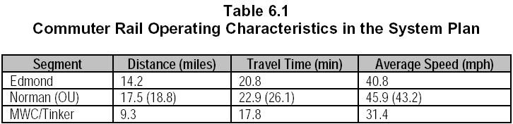
Mileage and travel time statistics of the commuter rail components are shown below:
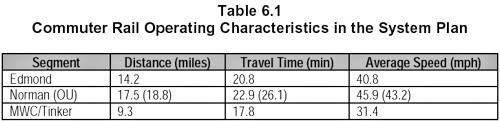 That's a fairly unambitious light rail mileage of only 31.0 or 32.3 miles, depending on the Norman (OU) component. Such a vision is certainly much less than what Mr. Stafford's article contemplates since it doesn't even include a Will Rogers Airport component. That's a fairly unambitious light rail mileage of only 31.0 or 32.3 miles, depending on the Norman (OU) component. Such a vision is certainly much less than what Mr. Stafford's article contemplates since it doesn't even include a Will Rogers Airport component.
If estimated cost was included in the report, I did not locate it.
My preliminary overview-observation is that, even if one might conclude that light-rail should be substituted (and it seems to be an either/or proposition) as the main substance of a MAPS III initiative/vote, until cost and location factors are known and objective cost information is available, it is difficult to cast aside the committee's MAPS III proposal for something more based on wishing and hoping which is not supported by much more specific and objective information. Also, see comments in this 2020 OkcCentral article (in the comments toward the bottom) for more about that.
- Do we really need a new convention center? Other than those who favor a total redirection in favor of light rail, a consensus of those commenting on the topic gives a new convention center the green light, even among those who have other criticisms of the overall proposal. In this group, see Dennis Wells' opinion that the Bricktown canal should be extended to the proposed convention center location which reads like tacit approval, and Bert Belanger expressly says, "I am okay with the MAPs 3 Convention Center Idea just South of the Ford Center."
However, this Gazette article by Scott Cooper raised the possibility that, in fact, the idea of a sparkling new and larger convention center may be overrated.
There is one person who would like to inform the Oklahoma City Council and residents that a new convention center may not be the answer: Heywood Sanders, a researcher with the University of Texas at San Antonio. He has studied the move by cities to construct mega-convention centers since the 1980s and would differ from the Greater Oklahoma City Chamber's consultant conclusion.
"The reality is, there has been a huge increase in the amount of supply (convention space) over the last 10 to 15 years," Sanders said. "Does that mean you get any more business? And the answer in general is 'no'." Since the late 1990s, convention-generated business has been on a downward slide, according to Sanders' research. Yet, during that same time, the number of cities and amount of convention center floor space skyrocketed, along with an increase in nearby hotel rooms. At least 53 cities either built new or expanded existing convention centers since 2000. Between 1986 and 2006, the number of convention centers across the country increased from 193 to 322. But since 1996, the number of convention attendees dropped. Sanders said the current rate of attendance is at 1993 levels.
"One of the things we know is the demand has not grown in the period since 2003," when the country started to come out of the recession caused by the Sept. 11 terrorist attacks, he said. "Most (cities) seem to be doing what they did before. It does suggest that as far as going forward, what we are seeing is not just a temporary downturn, particularly on the convention side, but a ratcheting down that may not ratchet back up." The article presents Greater Oklahoma City Chamber CEO Roy Williams' counterpoint to Heywood Sanders' observations, and, all in all, I found the article to be one of the better give-and-take discussions of MAPS III that I've read.
- Is the proposed boulevard too big? This one's a pretty hot topic. Interviews in the Journal Record's video provide the committee's perspective. As this is written, you can see it here (I'll change the link if I learn that it no longer works). At 3:55 into the 14 minute video, the boulevard is discussed. Mayor Cornett says that we should take a cue from Chicago and its magnificent Michigan Avenue — the "Magic Mile." Russell Klaus, city planner, says that, "It's not just a road, it's a gateway," and that it is intended to be the city's "new front door." Their intention is that the boulevard be something spectacular.
The rejoinder comes from people like Dennis Wells in his article at OkcCentral.com. He says,
Why are six new lanes of traffic needed where previously there were zero? An impressive new boulevard will be great where it's justified, but Core to Shore will already be lacerated once by the new I-40; why would we purposefully construct another pedestrian barrier? Where is it written that ALL of the old I-40 space has to be used for a boulevard? What if local artists competed to transform remnants of columns and/or roadway into works of art, or unique public spaces? The avoided demolition dollars could be used to create a signature landmark for the city. Hmmm ... I think that I'll need to reserve judgment on that proposed "art." I think that his statement that, "where previously there were were zero," is a bit of a stretch since the present-day Crosstown clearly exists and creates such a barrier today. But, the main point seems to be that a 6-lane super-boulevard would not be people-friendly and would not eliminate the existing barrier between the old downtown and the proposed "new" downtown element south of today's Crosstown.
 - Is the park area too small? Another contentious issue is the size of the Phase I park area — click the image at the right for a much better view. As I said in the Resources area, if one can wade through the meandering nature of on-line chat forums, and the occasional rudeness and bad manners, some good thoughts are often found if one is patient. The examples I'm giving for this subject are all to be found this thread inappropriately named, "Core To Shore Sucks," started by Nick Roberts, the title being admittedly chosen by him simply to draw attention. Regardless, the give and take presented in that thread illustrates the diversity of opinion about the park size. Please keep in mind that most posters in such forums refrain from using their real names and that will be the case in the examples which follow.
"Oil Capital" defended the size of the proposed park area. Here, he said:
Parks even much smaller than 40 acres can have a lot of different uses in them AND can attract development around them.
Look at Millennium Park. Look at Bryant Park in NYC. Look at Discovery Green in Houston.
Discovery Green, for example, is just over 12 acres. It's been open for about 1 & 1/2 years. Currently under construction on adjacent land: a 30 story office building, a 35 story apartment tower, and a 22 story hotel.
And, yes, there were many people on Houston development forums who confidently predicted abject failure for Discovery Green, just as you are doing with the (not even designed) OKC park. They said nobody would use it. They said it was too small. They said it would not attract any development around it. "Betts" had this to say:
Personally, I think the park planned for Core to Shore is a start. If my opinion can make a difference, I think we need to drop the block of business/retail between our new park and the Myriad Gardens, and I feel pretty strongly about that. If we can creatively bridge I-40, there's no reason we cannot work towards a second park that stretches to the river and which feels like an extension of the other park. We have to work with the terrain and budget we are given, but should push for as big a park as possible, even if it has to be built in stages, IMO.
I think there are parts of everyone's opinions that are correct. NYC has done very nicely with a massive park, and it has not had a negative effect on pedestrians. However, I also agree that one of the nice things about an urban landscape are surprises ... walking around the corner of a building and finding a small, perfect park ... seeing a mixture of different types of living and working environments. I don't have a problem with the park being the front lawn of a convention center, although I like the idea of using the mill area for a convention center better. I think it's a better location for conventioneers. I do think, however, that having some public buildings facing the park removes the concept that it is a park for the residents, primarily, a sense I think people might get if the park were surrounded by mid and high rise residential buildings only.
The nice thing about how much space we have to redevelop is that we can come up with multiple ideas for the same pieces of land. I'm not sure any of them are wrong, or any of them have to be right. What we should do is take the best ideas from multiple sources and come up with something unique to our city. "Krisb" said,
With OKC's density, or lack thereof, a smaller park could suit us well. It will make it feel more crowded and lively, rather than spread out and sparse with people. "Betts" also said,
Oil Capital, as I've said, I don't think it's the end of the world to have the park hemmed in by buildings on all sides, but why would it matter if the park were a block bigger and open to the Myriad Gardens. Would that be so bad? Might it be slightly better? Couldn't that development move over a block? That's what I don't understand. I see no way in which development on the north side of the park improves it. I agree that 40 acres is not a small park, but I also see nothing wrong with it being a bit bigger. I think there should be some flexibility inherent in Core to Shore, especially since we all know that there will be a lot of things in the plan that, over time, will end up being something other than what has been drawn. I'll give her the last word although several other posters commented about park size. Life is good. Lots of opinions and different points of view. But, frankly, in the end, is the size of the park going to be considered by anyone, or by very many, as a "deal breaker?" I doubt it. But, where's the harm in thinking through and perhaps reconsidering what the committee recommendations were for park size? None at all.
 - Should the convention center be located south of Bricktown instead of south of the Ford Center? So thinks former Mayor Kirk Humphreys, the mayor who campaigned on the slogan, "Finish MAPS Right." He said, "By golly, we've come this far – let's finish it first class." The original 3-year MAPS (I) didn't produce the funds to build the promised Ford Center and in a hotly contested mayoral race which centered upon a 6-month MAPS tax extension, Humphreys won hands down, 69% to 31%. On December 8, 1998, 44,000+ voters said, "Yes! We'll pay to finish it right," and, so, as a result, Oklahoma City got its Ford Center and you know what happened after that. He also led the highly successful campaign called "MAPS For Kids," also passing handily. His thoughts deserve serious attention.
A July 3, 2009, Oklahoman article by Steve Lackmeyer reports that,
Humphreys, meanwhile, is urging the city not to settle in on the south of Ford Center site for the convention center. Instead, he is urging them to look at buying the site of the Producer’s Co-op south of Lower Bricktown, which went up for sale last year.
Humphreys calculated walking distances of about a half-mile between the closest Bricktown eateries and the site south of the arena. In comparison, he said the distance from the cotton mill would only be about 250 feet.
"If you build it south of Ford Center people aren’t going to want to walk that far," Humphreys said. "They'll leave in their cars and go somewhere else. I think it's vital that a new convention center be as closely connected to Bricktown as possible." He's not alone in thinking that way. See Nick Roberts' impromptu plan which does the same. In a July 22 Oklahoma Gazette article by Scott Cooper, the journalist said,
But some Bricktown merchants are concerned a new convention center located further south from the Cox location could cut off business to the Bricktown area. They say extending the canal from Bricktown to the new center would keep business flowing. "I think you get conflicting opinions on that," the mayor [Mayor Cornett] said. "If the issue is connectivity, there are other ways to provide connectivity." Building the convention center in the Producers' Coop area which is reportedly up for sale is certainly one such way. Although the focus of the Gazette article was to include an extension of the Bricktown Canal into MAPS III to connect to the committee's location of the proposed convention center and other downtown areas, the point is the same.
Other points for consideration: By moving the convention center's location, those who want a greater park space could be accommodated, and those who are concerned about destruction of some existing buildings west of the BNSF railroad tracks, below, could be, also.
 - Is it not possible and wouldn't it be good to save and use more of the existing buildings? Yes and No. As for the three buildings previously identified which are between Broadway and the BNSF railroad tracks and south of the Ford Center, two of those buildings are in the footprint of the proposed convention center, including the best of the lot, the 1909 International Harvester Building shown below. With the other two buildings gone, the southernmost building would rather look like a sore thumb being surrounded by urban newness. That doesn't fit. But if the convention center were located south of Bricktown, possibilities open up for all three of those buildings to be preserved.
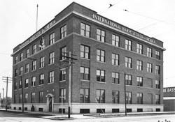
Credit Steve Lackmeyer's Bricktown (2009) |
International Harvester Today |
As for buildings along or near Robinson, it doesn't have to happen even if the convention center location stays put. As Steve Lackmeyer opined here and here, some of those buildings could be saved and with the same charm that resulted in a precious few buildings being saved in Deep Deuce. In this Journal Record article, the reporter said:
Mark Beffort, with Grubb & Ellis Levy Beffort, has been hired by the city to assist in acquisition of properties for Core to Shore. Beffort came on just after the post office deal, but will handle all future acquisitions from negotiation to closing.
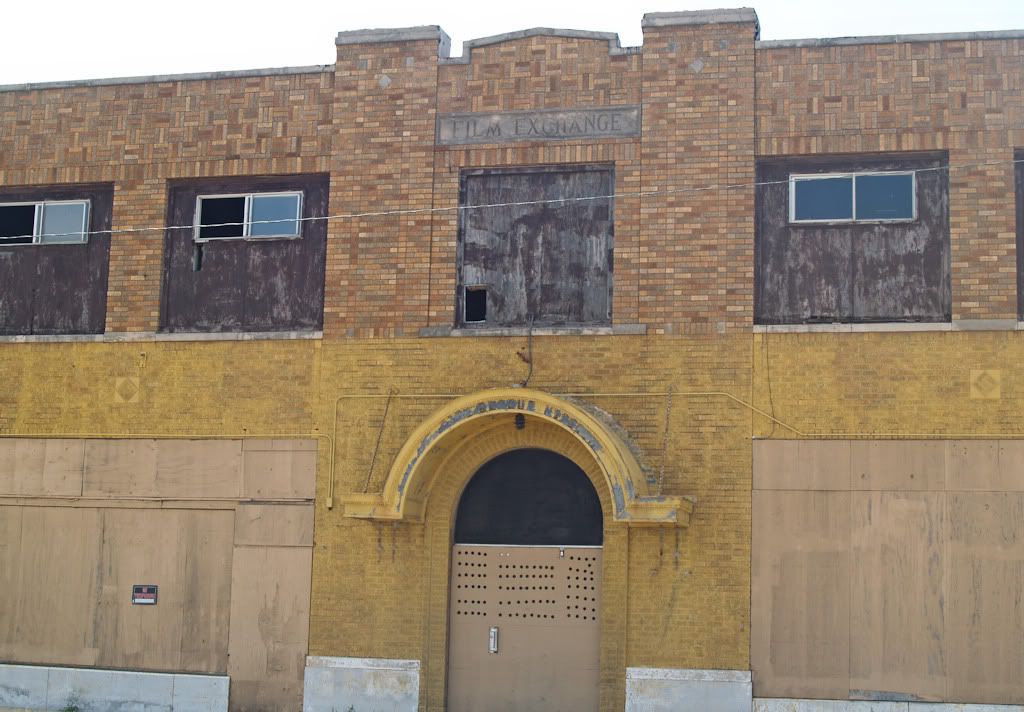
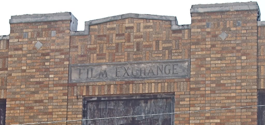
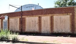
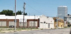
For now, Beffort said, the city is looking no farther than the proposed park area. The city is considering several properties around the proposed park but nothing is under contract. "Our primary concentration today is the park area and then one block off each side of the park," Beffort said. In Phase I, one block either side of Robinson would encompass every building along Robinson on either side down to SW 7th, including, but not limited to, the Film Exchange Building in the 500 block on the west side of Robinson, below. When was it built and how is it historically significant? At this point, I've not found those details but I'll amend this part when I do, very soon. Whenever, as shown below, it was obviously not as ugly as it is today.
Film Exchange Building in 1946
 Do we really want to destroy yet another round of buildings which link our city's past with our city of today? I'm one of those who wonders, "Can we not find a better way?" Do we really want to destroy yet another round of buildings which link our city's past with our city of today? I'm one of those who wonders, "Can we not find a better way?"
- What about the "Modern Streetcars" – is it enough to sway light rail advocates? Of all the possible projects which are probable for MAPS III, this one may perhaps be the most intriguing to voters, for two reasons: (1) The unscientific on-line survey conducted by the city reflect that the "Transit (light rail, streetcars, etc.)" category was the clear-cut favorite, receiving 668 votes (the next highest was infrastructure and streets at 188); and (2) the plan has the potential to serve more than downtown and might be seen as a springboard to a more robust commuter light rail system.
 The efforts of Jeff Bezdek, James Ellison, Mark Gibbs and Austin Hacker, and their organization Modern Transit Project (MTP), are perhaps the most visible proponents of this element of MAPS III. The efforts of Jeff Bezdek, James Ellison, Mark Gibbs and Austin Hacker, and their organization Modern Transit Project (MTP), are perhaps the most visible proponents of this element of MAPS III.
 Even though MAPS III doesn't apparently intend to extend the modern street car system north of downtown at present (at least, that's not said in the committee report), the goal of MTP is to extend north of downtown as shown in the image at the right. Even though MAPS III doesn't apparently intend to extend the modern street car system north of downtown at present (at least, that's not said in the committee report), the goal of MTP is to extend north of downtown as shown in the image at the right.
The committee report isn't very specific when it identifies the path as being, "A bi-directional loop operating along Robinson and Walker Avenues from the downtown core to the Oklahoma River, with extensions to the south as development continues." And, of course, one of the problems in think MAPS III issues through, generally, is the vagueness which presently exits.
A pair of articles are worth looking at — Item 1: Steve Lackmeyer's July 14, 2009, Oklahoman article, and Item 2: Ben Fenwick and Robbin Collins' July 22, 2009, Gazette article.
Although this non-suburban system is certainly not the commuter light rail advocated by proponents of the same, perhaps it is enough of a start in the right direction to gain their approval.
- What's In MAPS III For Me? That's what some people may be wondering. Even though MAPS I largely focused on downtown, it also included projects more far afield such as the Oklahoma River and improvements to the State Fairgrounds. MAPS For Kids covered the entire school system. The March 4, 2008, Ford Center vote appealed to people everywhere around town who wanted the city to have an NBA team.
Reservations have been expressed by at least a couple of Council Members that their constituents need to see "what's in it for them." The July 22, 2009, Gazette article reported as follows:
"I hear repeatedly ... there needs to be some balance in this MAPS 3 to pass," said Ward 2 Councilman Sam Bowman. "It's got to be more than a downtown MAPS initiative. It's got to have something for the rest of us."
* * *
Then there is the third crowd, and maybe the more controversial. When Cornett sought public input on what projects were needed, the buzz was transportation. Yet when Cornett held his annual Mayor's Development Roundtable at the Cox Convention Center in May, the focus was on a new convention center project with a privately funded adjoining hotel. It was a hit among the business and community leaders in attendance, but another project for the downtown area costing hundreds of millions of dollars may not sit so well outside of the business community.
"My constituents want to see more balance," said Ward 4 Councilman Pete White. "If the big impact is downtown, (for) people in the rural and semi-rural areas, it will be hard to see the value. "I'm still waiting to be sold this is the right thing to do." Unquestionably and however one cuts it, the present MAPS III focus is on continuing the downtown momentum generated by the success of MAPS I. Whether enough voters perceive their own identification with and involvement in "downtown" may well tell the tale of MAPS III.
WHAT'S THE TIMELINE? The July 22, 2009, Gazette article cited above says,
The City Council has until Oct. 6 to approve a MAPS 3 resolution for voters to decide on in December before the tax expires. Cornett said officials have set a target date of Sept. 29 to come up with the final proposal. CONCLUSION. My conclusion? I've not reached conclusions on all the details yet, but that's not the point or purpose of this article. First and foremost, my intentions are to provide resources and to contribute to the discussion about shaping MAPS III in a positive way. Not only is my thought incomplete as to the some of the items discussed above, important data remains unclear about exactly what it is that city leaders may choose to present to the voters, presumably in December 2009. We are led to believe that citizen input has the potential of possible change to the committee report, and I hope that is the case.
That said, in the end and after all is said and done, chances are good that I'll favor the final product since I am one who does strongly identify with downtown as the heart and heartbeat of the city and I am one who wants the MAPS I momentum to continue, even if I may not be completely happy with all of its parts.
That is because of my opinion that, of everything that Oklahoma City is, downtown is the one thing that we all share in common whether that be through reminiscing about times long gone by or anticipating those days which are yet to come. I remember the time that I was not proud of my city. That was when I was not proud of downtown after Urban Renewal destroyed many of its best parts and failed to deliver on the promises made. I remember those days that I became proud once again, a long time coming, following MAPS I. Those were the days that downtown, although different from the downtown of my nostalgic remembrances, again became a vital and energetic place to be, just as it had been in days gone by, even if the looking glass showed images of something altogether different.
I still miss that old downtown with the John A. Brown's, Rothschilds, domino parlors, movie theaters, etc., and all of its disorganized chaos.
Urban Renewal caused the destruction of the old view of downtown. After a long-time stall, MAPS I brought about the new. Although accomplishing enormous good, MAPS I did not restore the serendipity or the chaos except perhaps in Bricktown. But, it did change most Oklahoman Citians' perspective about their home and their view of themselves as Oklahoma Citians. City pride, at long last, perhaps analogous to the glorious 1920-1932 heyday period, once again emerged.
I do hope that MAPS III will preserve a little urban grit and messiness and save old structures in the Phase I when that can be done and, beyond Phase I, that Phases II and III (about which I've not said very much in the discussion) won't be as suburban looking as some of those peripheral parts surrounding Phase I areas presently strike me as being. Some of those areas are much too planned and laid out to suit a guy like me who enjoys a good bit of chaos and the unexpected in downtowns that I like to visit, including my own. But, that's another story for a different day.
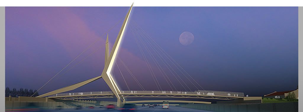
My hope is that the final MAPS III Phase I will excite me, and you, as much as this fine Skydance Pedestrian Bridge does which has already been approved to cross the relocated I-40 when it is completed south of downtown.
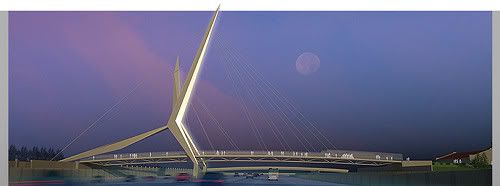
It would be a good thing, I think, if that fine pedestrian bridge has one set of great places to cross from and another set of great places to cross to, at both of its ends.
Go To Top
... Click here to read the full article and any comments ...
|