
Although it should be more than clear by now about Doug Dawgz preference in this matter, I have no wish or reason to misstate facts or twist them to suit my purposes. The "Vote No" people did that sort of thing abundantly during the campaign, but that is not my way. While this post confirms that a substantial majority of Oklahoma City voters voted, "YES," the data provided by the Oklahoma County Election Board also reflects that parts of Oklahoma City did not. This post contains the data and the unvarnished facts of who voted how, and where.
The corporate limits of Oklahoma City include a substantial part of Oklahoma County but also pieces of Canadian, Cleveland, and a pinch of Pottawatomie Counties. "Oklahoma City" proper is divided into "wards" and each "ward" is further subdivided into "precincts" (although, on occasion, I found that some precincts overlap ward boundaries). When writing the 1st version of this post, I was unaware of an internet location where all precincts could be identified ... but thanks to Dustbury's C.G. Hill and Batesline's Michael Bates, both of whom kindly gave me this link to OU's Center for Spatial Analysis, all Oklahoma City precincts have been identified in whichever county they may be located.
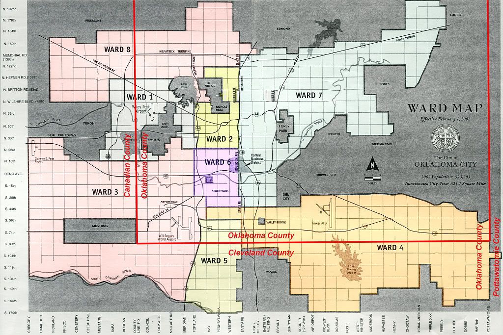
Oklahoma City's "Ward" map looks like this ...
or click the map below for a medium high resolution map:
I ventured to the Oklahoma County Election Board offices on North Lincoln on March 6 ... the "official" vote tallies were not then available ... but the "unofficial" tallies as of March 4 at 9:30 p.m. were. They gave me a printout of the "unofficial" and therefore incomplete results of the March 4 vote, as well as some very cool maps, showing the voting precincts located within Oklahoma City proper ... parts of which extend into parts of Cleveland, Canadian, and Pottawatomie counties. Their courtesies and gifts of maps, etc., were beyond my expectations, and I thank the Oklahoma County Election Board for that.
I was particularly interested in seeing which areas of "Oklahoma City" voted "Yes" or "No," and I was interested in seeing if one or more patterns existed concerning the same. In my precinct, 550485, the vote was 599 to 226, "Yes" carrying by 72.61%! Hoo ahh! But, while the vote carried in 164 precincts, it failed in 84 and tied in 2, as is graphically shown below.
The "reddish-orange" precincts are those voting "No" and the "greenish" precincts voted "Yes:"
or click the map below for a medium high resolution map:
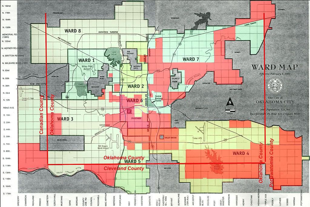
I tried placing numbers on the precincts but the map got much too fussy looking. Notice, above, that no precinct in Ward 8 voted "No" and not many in Wards 1 and 2 did. Ward 5 was largely, "Yes," also. But in Wards 3, 4, 6, and 7, the map contains many "dark" precincts. For a similar map published in Sunday's Oklahoman, click here.
As I've already said, "Oklahoma City" proper includes some, but certainly not all, of Oklahoma County ... as you know, such incorporated cities like Edmond, Midwest City, Del City, The Village, Nichols Hills, etc., while located in Oklahoma County, are not part of Oklahoma City proper. Beyond Oklahoma County, parts of "Oklahoma City" proper are located in Canadian, Cleveland, and even a pinch of an inch in Pottawatomie County.
If viewed by "Wards," all but one Ward, Ward 4, voted "Yes," and the No vote barely carried Ward 4. The following image shows the Ward detail:

From the above, it is very evident that those who preferred the measure were much more inclined to get to the polls and vote.
The Oklahoma County Election Board data reflected the following data ... I supplied the precinct percentages ... I'm guessing that the "N/A" precincts were not in Oklahoma City proper but were in the County ... C.G. Hill thinks that correct ... I supplied the "N/A" notation which was not in the printout.
| Run Date: 03-04-08 9:20 pm March 4, 2008 | |||||
| Unofficial Returns From the Oklahoma County Election Board | |||||
| County | Precinct | Yes | No | Result % | |
| Oklahoma | 550301 | 23 | 21 | Yes | 52.27% |
| Oklahoma | 550304 | 96 | 113 | No | 54.07% |
| Oklahoma | 550308 | 0 | 0 | N/A | N/A |
| Oklahoma | 550315 | 133 | 53 | Yes | 71.51% |
| Oklahoma | 550321 | 32 | 53 | No | 62.35% |
| Oklahoma | 550325 | 0 | 0 | N/A | N/A |
| Oklahoma | 550326 | 0 | 0 | N/A | N/A |
| Oklahoma | 550336 | 8 | 0 | Yes | 100.00% |
| Oklahoma | 550340 | 25 | 24 | Yes | 51.02% |
| Oklahoma | 550342 | 9 | 2 | Yes | 81.82% |
| Oklahoma | 550343 | 27 | 5 | Yes | 84.38% |
| Oklahoma | 550344 | 298 | 72 | Yes | 80.54% |
| Oklahoma | 550356 | 0 | 0 | N/A | N/A |
| Oklahoma | 550360 | 103 | 44 | Yes | 70.07% |
| Oklahoma | 550365 | 50 | 28 | Yes | 64.10% |
| Oklahoma | 550366 | 10 | 12 | No | 54.55% |
| Oklahoma | 550369 | 9 | 10 | No | 52.63% |
| Oklahoma | 550370 | 7 | 9 | No | 56.25% |
| Oklahoma | 550371 | 0 | 0 | N/A | N/A |
| Oklahoma | 550378 | 0 | 0 | N/A | N/A |
| Oklahoma | 550392 | 0 | 0 | N/A | N/A |
| Oklahoma | 550397 | 30 | 6 | Yes | 83.33% |
| Oklahoma | 550398 | 127 | 31 | Yes | 80.38% |
| Oklahoma | 550401 | 0 | 0 | N/A | N/A |
| Oklahoma | 550402 | 110 | 13 | Yes | 89.43% |
| Oklahoma | 550403 | 116 | 44 | Yes | 72.50% |
| Oklahoma | 550404 | 343 | 96 | Yes | 78.13% |
| Oklahoma | 550405 | 540 | 126 | Yes | 81.08% |
| Oklahoma | 550406 | 67 | 21 | Yes | 76.14% |
| Oklahoma | 550407 | 180 | 49 | Yes | 78.60% |
| Oklahoma | 550408 | 574 | 180 | Yes | 76.13% |
| Oklahoma | 550409 | 77 | 29 | Yes | 72.64% |
| County | Precinct | Yes | No | Result % | |
| Oklahoma | 550410 | 2 | 0 | Yes | 100.00% |
| Oklahoma | 550411 | 64 | 22 | Yes | 74.42% |
| Oklahoma | 550412 | 45 | 25 | Yes | 64.29% |
| Oklahoma | 550413 | 160 | 95 | Yes | 62.75% |
| Oklahoma | 550414 | 457 | 121 | Yes | 79.07% |
| Oklahoma | 550415 | 616 | 198 | Yes | 75.68% |
| Oklahoma | 550416 | 536 | 101 | Yes | 84.14% |
| Oklahoma | 550417 | 0 | 0 | N/A | N/A |
| Oklahoma | 550418 | 0 | 0 | N/A | N/A |
| Oklahoma | 550419 | 751 | 228 | Yes | 76.71% |
| Oklahoma | 550420 | 550 | 122 | Yes | 81.85% |
| Oklahoma | 550421 | 682 | 283 | Yes | 70.67% |
| Oklahoma | 550422 | 343 | 116 | Yes | 74.73% |
| Oklahoma | 550423 | 410 | 207 | Yes | 66.45% |
| Oklahoma | 550424 | 760 | 221 | Yes | 77.47% |
| Oklahoma | 550425 | 533 | 213 | Yes | 71.45% |
| Oklahoma | 550426 | 205 | 75 | Yes | 73.21% |
| Oklahoma | 550427 | 130 | 48 | Yes | 73.03% |
| Oklahoma | 550428 | 488 | 205 | Yes | 70.42% |
| Oklahoma | 550429 | 595 | 233 | Yes | 71.86% |
| Oklahoma | 550430 | 457 | 197 | Yes | 69.88% |
| Oklahoma | 550431 | 656 | 344 | Yes | 65.60% |
| Oklahoma | 550432 | 764 | 354 | Yes | 68.34% |
| Oklahoma | 550433 | 202 | 129 | Yes | 61.03% |
| Oklahoma | 550434 | 506 | 215 | Yes | 70.18% |
| Oklahoma | 550435 | 327 | 158 | Yes | 67.42% |
| Oklahoma | 550436 | 357 | 201 | Yes | 63.98% |
| Oklahoma | 550437 | 354 | 143 | Yes | 71.23% |
| Oklahoma | 550438 | 241 | 121 | Yes | 66.57% |
| Oklahoma | 550439 | 266 | 93 | Yes | 74.09% |
| Oklahoma | 550440 | 175 | 77 | Yes | 69.44% |
| Oklahoma | 550441 | 297 | 108 | Yes | 73.33% |
| County | Precinct | Yes | No | Result % | |
| Oklahoma | 550442 | 431 | 228 | Yes | 65.40% |
| Oklahoma | 550443 | 0 | 0 | N/A | N/A |
| Oklahoma | 550444 | 251 | 109 | Yes | 69.72% |
| Oklahoma | 550445 | 156 | 114 | Yes | 57.78% |
| Oklahoma | 550446 | 292 | 206 | Yes | 58.63% |
| Oklahoma | 550447 | 27 | 29 | No | 51.79% |
| Oklahoma | 550448 | 415 | 220 | Yes | 65.35% |
| Oklahoma | 550449 | 255 | 210 | Yes | 54.84% |
| Oklahoma | 550450 | 200 | 75 | Yes | 72.73% |
| Oklahoma | 550451 | 128 | 83 | Yes | 60.66% |
| Oklahoma | 550452 | 766 | 330 | Yes | 69.89% |
| Oklahoma | 550453 | 435 | 247 | Yes | 63.78% |
| Oklahoma | 550454 | 250 | 205 | Yes | 54.95% |
| Oklahoma | 550455 | 257 | 208 | Yes | 55.27% |
| Oklahoma | 550456 | 105 | 70 | Yes | 60.00% |
| Oklahoma | 550457 | 222 | 163 | Yes | 57.66% |
| Oklahoma | 550458 | 333 | 244 | Yes | 57.71% |
| Oklahoma | 550459 | 75 | 59 | Yes | 55.97% |
| Oklahoma | 550460 | 260 | 285 | No | 52.29% |
| Oklahoma | 550461 | 95 | 72 | Yes | 56.89% |
| Oklahoma | 550462 | 70 | 65 | Yes | 51.85% |
| Oklahoma | 550463 | 170 | 119 | Yes | 58.82% |
| Oklahoma | 550464 | 229 | 202 | Yes | 53.13% |
| Oklahoma | 550465 | 14 | 22 | No | 61.11% |
| Oklahoma | 550466 | 75 | 83 | No | 52.53% |
| Oklahoma | 550467 | 254 | 229 | Yes | 52.59% |
| Oklahoma | 550468 | 107 | 113 | No | 51.36% |
| Oklahoma | 550469 | 34 | 51 | No | 60.00% |
| Oklahoma | 550470 | 8 | 31 | No | 79.49% |
| Oklahoma | 550471 | 159 | 136 | Yes | 53.90% |
| Oklahoma | 550472 | 288 | 201 | Yes | 58.90% |
| Oklahoma | 550473 | 204 | 196 | Yes | 51.00% |
| County | Precinct | Yes | No | Result % | |
| Oklahoma | 550474 | 297 | 178 | Yes | 62.53% |
| Oklahoma | 550475 | 65 | 53 | Yes | 55.08% |
| Oklahoma | 550476 | 186 | 150 | Yes | 55.36% |
| Oklahoma | 550477 | 154 | 130 | Yes | 54.23% |
| Oklahoma | 550478 | 402 | 192 | Yes | 67.68% |
| Oklahoma | 550479 | 306 | 105 | Yes | 74.45% |
| Oklahoma | 550480 | 339 | 192 | Yes | 63.84% |
| Oklahoma | 550481 | 155 | 147 | Yes | 51.32% |
| Oklahoma | 550482 | 53 | 47 | Yes | 53.00% |
| Oklahoma | 550483 | 237 | 134 | Yes | 63.88% |
| Oklahoma | 550484 | 83 | 90 | No | 52.02% |
| Oklahoma | 550485 | 599 | 226 | Yes | 72.61% |
| Oklahoma | 550486 | 116 | 63 | Yes | 64.80% |
| Oklahoma | 550487 | 2 | 0 | Yes | 100.00% |
| Oklahoma | 550488 | 50 | 59 | No | 54.13% |
| Oklahoma | 550489 | 188 | 158 | Yes | 54.34% |
| Oklahoma | 550490 | 80 | 78 | Yes | 50.63% |
| Oklahoma | 550491 | 144 | 85 | Yes | 62.88% |
| Oklahoma | 550492 | 152 | 127 | Yes | 54.48% |
| Oklahoma | 550493 | 117 | 194 | No | 62.38% |
| Oklahoma | 550494 | 59 | 86 | No | 59.31% |
| Oklahoma | 550495 | 33 | 67 | No | 67.00% |
| Oklahoma | 550496 | 63 | 50 | Yes | 55.75% |
| Oklahoma | 550497 | 34 | 51 | No | 60.00% |
| Oklahoma | 550498 | 42 | 83 | No | 66.40% |
| Oklahoma | 550499 | 87 | 135 | No | 60.81% |
| Oklahoma | 550500 | 25 | 30 | No | 54.55% |
| Oklahoma | 550501 | 83 | 116 | No | 58.29% |
| Oklahoma | 550502 | 130 | 148 | No | 53.24% |
| Oklahoma | 550503 | 54 | 118 | No | 68.60% |
| Oklahoma | 550504 | 86 | 131 | No | 60.37% |
| Oklahoma | 550505 | 146 | 164 | No | 52.90% |
| County | Precinct | Yes | No | Result % | |
| Oklahoma | 550506 | 144 | 206 | No | 58.86% |
| Oklahoma | 550507 | 72 | 119 | No | 62.30% |
| Oklahoma | 550508 | 57 | 113 | No | 66.47% |
| Oklahoma | 550509 | 108 | 130 | No | 54.62% |
| Oklahoma | 550510 | 138 | 141 | No | 50.54% |
| Oklahoma | 550511 | 284 | 313 | No | 52.43% |
| Oklahoma | 550512 | 176 | 177 | No | 50.14% |
| Oklahoma | 550513 | 23 | 44 | No | 65.67% |
| Oklahoma | 550514 | 92 | 57 | Yes | 61.74% |
| Oklahoma | 550515 | 186 | 227 | No | 54.96% |
| Oklahoma | 550516 | 262 | 280 | No | 51.66% |
| Oklahoma | 550517 | 237 | 207 | Yes | 53.38% |
| Oklahoma | 550518 | 82 | 96 | No | 53.93% |
| Oklahoma | 550519 | 150 | 191 | No | 56.01% |
| Oklahoma | 550520 | 144 | 167 | No | 53.70% |
| Oklahoma | 550521 | 55 | 120 | No | 68.57% |
| Oklahoma | 550522 | 52 | 100 | No | 65.79% |
| Oklahoma | 550523 | 63 | 70 | No | 52.63% |
| Oklahoma | 550524 | 20 | 29 | No | 59.18% |
| Oklahoma | 550525 | 45 | 58 | No | 56.31% |
| Oklahoma | 550526 | 86 | 104 | No | 54.74% |
| Oklahoma | 550527 | 73 | 173 | No | 70.33% |
| Oklahoma | 550528 | 102 | 128 | No | 55.65% |
| Oklahoma | 550529 | 5 | 12 | No | 70.59% |
| Oklahoma | 550530 | 16 | 33 | No | 67.35% |
| Oklahoma | 550531 | 0 | 1 | No | 100.00% |
| Oklahoma | 550532 | 72 | 77 | No | 51.68% |
| Oklahoma | 550533 | 202 | 211 | No | 51.09% |
| Oklahoma | 550534 | 167 | 136 | Yes | 55.12% |
| Oklahoma | 550535 | 351 | 207 | Yes | 62.90% |
| Oklahoma | 550536 | 0 | 0 | N/A | N/A |
| Oklahoma | 550537 | 21 | 17 | Yes | 55.26% |
| County | Precinct | Yes | No | Result % | |
| Oklahoma | 550538 | 0 | 0 | N/A | N/A |
| Oklahoma | 550539 | 0 | 0 | N/A | N/A |
| Oklahoma | 550540 | 27 | 2 | Yes | 93.10% |
| Oklahoma | 550541 | 5 | 0 | Yes | 100.00% |
| Oklahoma | 550542 | 165 | 114 | Yes | 59.14% |
| Oklahoma | 550543 | 147 | 161 | No | 52.27% |
| Oklahoma | 550544 | 118 | 157 | No | 57.09% |
| Oklahoma | 550545 | 130 | 130 | Even | 50.00% |
| Oklahoma | 550546 | 27 | 32 | No | 54.24% |
| Oklahoma | 550547 | 91 | 111 | No | 54.95% |
| Oklahoma | 550548 | 103 | 64 | Yes | 61.68% |
| Oklahoma | 550549 | 131 | 143 | No | 52.19% |
| Oklahoma | 550550 | 180 | 223 | No | 55.33% |
| Oklahoma | 550551 | 164 | 199 | No | 54.82% |
| Oklahoma | 550552 | 168 | 220 | No | 56.70% |
| Oklahoma | 550553 | 130 | 184 | No | 58.60% |
| Oklahoma | 550554 | 2 | 3 | No | 60.00% |
| Oklahoma | 550555 | 5 | 4 | Yes | 55.56% |
| Oklahoma | 550556 | 22 | 27 | No | 55.10% |
| Oklahoma | 550557 | 11 | 10 | Yes | 52.38% |
| Oklahoma | 550558 | 8 | 2 | Yes | 80.00% |
| Oklahoma | 550559 | 10 | 15 | No | 60.00% |
| Oklahoma | 550560 | 74 | 52 | Yes | 58.73% |
| Oklahoma | 550561 | 102 | 62 | Yes | 62.20% |
| Oklahoma | 550562 | 296 | 191 | Yes | 60.78% |
| Oklahoma | 550563 | 50 | 26 | Yes | 65.79% |
| Oklahoma | 550564 | 84 | 54 | Yes | 60.87% |
| Oklahoma | 550565 | 228 | 122 | Yes | 65.14% |
| Oklahoma | 550566 | 302 | 216 | Yes | 58.30% |
| Oklahoma | 550567 | 0 | 0 | N/A | N/A |
| Oklahoma | 550568 | 206 | 52 | Yes | 79.84% |
| Oklahoma | 550569 | 318 | 91 | Yes | 77.75% |
| County | Precinct | Yes | No | Result % | |
| Oklahoma | 550570 | 70 | 76 | No | 52.05% |
| Oklahoma | 550571 | 208 | 107 | Yes | 66.03% |
| Oklahoma | 550572 | 0 | 0 | N/A | N/A |
| Oklahoma | 550573 | 81 | 37 | Yes | 68.64% |
| Oklahoma | 550574 | 377 | 127 | Yes | 74.80% |
| Oklahoma | 550575 | 9 | 8 | Yes | 52.94% |
| Oklahoma | 550576 | 40 | 50 | No | 55.56% |
| Oklahoma | 550577 | 4 | 4 | Even | 50.00% |
| Oklahoma | 550578 | 3 | 5 | No | 62.50% |
| Oklahoma | 550579 | 76 | 110 | No | 59.14% |
| Oklahoma | 550580 | 12 | 17 | No | 58.62% |
| Oklahoma | 550581 | 223 | 162 | Yes | 57.92% |
| Oklahoma | 550582 | 335 | 240 | Yes | 58.26% |
| Oklahoma | 550583 | 179 | 168 | Yes | 51.59% |
| Oklahoma | 550584 | 143 | 134 | Yes | 51.62% |
| Oklahoma | 550585 | 34 | 43 | No | 55.84% |
| Oklahoma | 550586 | 0 | 2 | No | 100.00% |
| Oklahoma | 550587 | 9 | 14 | No | 60.87% |
| Oklahoma | 550588 | 0 | 1 | No | 100.00% |
| Oklahoma | 550589 | 84 | 67 | Yes | 55.63% |
| Oklahoma | 550590 | 0 | 0 | N/A | N/A |
| Oklahoma | 550591 | 39 | 53 | No | 57.61% |
| Oklahoma | 550594 | 0 | 0 | N/A | N/A |
| Oklahoma | In Person Absentee | 646 | 380 | Yes | 62.96% |
| Oklahoma | Mail In Absentee | 684 | 599 | Yes | 53.31% |
| Canadian | 090126 | 35 | 15 | Yes | 70.00% |
| Canadian | 090200 | 583 | 191 | Yes | 75.32% |
| Canadian | 090201 | 82 | 51 | Yes | 61.65% |
| Canadian | 090205 | 4 | 1 | Yes | 80.00% |
| Canadian | 090206 | 10 | 4 | Yes | 71.43% |
| Canadian | 090215 | 177 | 106 | Yes | 62.54% |
| Canadian | 090220 | 309 | 110 | Yes | 73.75% |
| County | Precinct | Yes | No | Result % | |
| Canadian | 090221 | 263 | 90 | Yes | 74.50% |
| Canadian | 090222 | 166 | 100 | Yes | 62.41% |
| Canadian | 090223 | 110 | 82 | Yes | 57.29% |
| Canadian | 090224 | 66 | 78 | No | 54.17% |
| Canadian | 090225 | 333 | 150 | Yes | 68.94% |
| Canadian | 090226 | 97 | 59 | Yes | 62.18% |
| Canadian | 090227 | 316 | 105 | Yes | 75.06% |
| Canadian | 090300 | 18 | 16 | Yes | 52.94% |
| Canadian | 090302 | 44 | 40 | Yes | 52.38% |
| Canadian | 090304 | 45 | 35 | Yes | 56.25% |
| Canadian | 090305 | 8 | 6 | Yes | 57.14% |
| Canadian | 090306 | 26 | 28 | No | 51.85% |
| Canadian | 090506 | 93 | 41 | Yes | 69.40% |
| Canadian | 090700 | 0 | 0 | N/A | N/A |
| Canadian | 090701 | 0 | 0 | N/A | N/A |
| Canadian | Absentee | 55 | 58 | No | 51.33% |
| Cleveland | 140004 | 658 | 205 | Yes | 76.25% |
| Cleveland | 140005 | 397 | 202 | Yes | 66.28% |
| Cleveland | 140007 | 55 | 46 | Yes | 54.46% |
| Cleveland | 140009 | 359 | 158 | Yes | 69.44% |
| Cleveland | 140010 | 310 | 192 | Yes | 61.75% |
| Cleveland | 140017 | 73 | 65 | Yes | 52.90% |
| Cleveland | 140020 | 356 | 109 | Yes | 76.56% |
| Cleveland | 140023 | 44 | 57 | No | 56.44% |
| Cleveland | 140024 | 11 | 9 | Yes | 55.00% |
| Cleveland | 140036 | 33 | 32 | Yes | 50.77% |
| Cleveland | 140037 | 70 | 37 | Yes | 65.42% |
| Cleveland | 140040 | 313 | 179 | Yes | 63.62% |
| Cleveland | 140041 | 206 | 118 | Yes | 63.58% |
| Cleveland | 140043 | 235 | 96 | Yes | 71.00% |
| Cleveland | 140050 | 395 | 272 | Yes | 59.22% |
| Cleveland | 140060 | 74 | 45 | Yes | 62.18% |
| County | Precinct | Yes | No | Result % | |
| Cleveland | 140061 | 432 | 242 | Yes | 64.09% |
| Cleveland | 140063 | 41 | 40 | Yes | 50.62% |
| Cleveland | 140064 | 88 | 93 | No | 51.38% |
| Cleveland | 140065 | 10 | 13 | No | 56.52% |
| Cleveland | 140066 | 26 | 34 | No | 56.67% |
| Cleveland | 140069 | 406 | 306 | Yes | 57.02% |
| Cleveland | 140072 | 36 | 27 | Yes | 57.14% |
| Cleveland | 140078 | 86 | 90 | No | 51.14% |
| Cleveland | 140085 | 24 | 25 | No | 51.02% |
| Cleveland | 140086 | 408 | 149 | Yes | 73.25% |
| Cleveland | 140087 | 81 | 96 | No | 54.24% |
| Cleveland | 140088 | 549 | 237 | Yes | 69.85% |
| Cleveland | Absentee | 131 | 122 | Yes | 51.78% |
| Pottawatomie | 630025 | 2 | 1 | Yes | 66.67% |
| Pottawatomie | Absentee | 0 | 0 | N/A | N/A |
| Summary | Yes | No | Even | N/A | All |
| Ballots | 44,849 | 27,564 | --- | --- | 72,413 |
| Precincts | 164 | 84 | 2 | 21 | |
| 61.94% | 38.06% | ||||
Links:
Chamber's Big League City MySpace Page
Chamber's Big League City web page
Related blog posts:
- We Are The Champions
- Can It Fail?
- Breaking Through
- march4vote.org
- Bricktown Bash
- Roy Williams at Cafe Do Brazil
- Ford Center Watch Party
- Tramel Gets It Right
- Unabashed Pro March 4 Vote Video
- Ford Center Initiative
- Hornets 2 Year Retrospective Flash Video
- Okc ... Yes or No, on getting an NBA team
- Okc in NBA ... Where Are We?


2 comments:
I spot-checked some of your "N/A"
precincts against a precinct map, and they were indeed outside Oklahoma City limits.
Go to this page
http://geo.ou.edu/MapsFrame.htm
then select "Oklahoma City" from the pull-down menu, and it will pop up a PDF showing streets, corporate limits, and precinct boundaries.
Post a Comment