
This post is divided into sections ... click a link to move directly to that area.
| History | Memories | Maps | Pictures |
HISTORY. According to the OHS Encyclopedia of Oklahoma History website, the 59,000+ acres wildlife refuge area has these origins:
In 1901, prior to the Kiowa-Comanche-Apache Opening, Pres. William McKinley proclaimed a portion of the mountains as the Wichita Forest Reserve, assigned to the Forestry Division of the General Land Office of the U.S. Department of the Interior. In 1905 the reserve was transferred to the Bureau of Forestry under the U.S. Department of Agriculture. Later that year, after Congress passed a bill authorizing a federal wildlife refuge, Pres. Theodore Roosevelt issued a proclamation creating the Wichita Forest and Game Preserve as the nation's first big-game animal (and other native wildlife) refuge. Earlier, Roosevelt had established several national bird sanctuaries. In 1906 Roosevelt issued second proclamation, adding 3,680 acres to the refuge. In 1907 the park became the Wichita National Forest and Game Preserve, when all forest reserves were reclassified as National Forests. In 1936 Congress renamed the area the Wichita Mountains National Wildlife Refuge and transferred it to the Bureau of Biological Survey. In 1939 federal refuges moved back to Department of Interior control. In 1940 the Biological Survey and the Bureau of Fisheries combined to become the U.S. Fish and Wildlife Service, which continued to administer the Wichita Wildlife Refuge into the twenty-first century.See the full article for more and the brief history by the US Fish & Wildlife Service for less.
Note, however, that the full history of the region predates the existence of the United States by many millions of years, it being one of the oldest mountain areas in North America. See this Wikipedia article for more about geology and such things.
MEMORIES. As a kid in the 1950s and ending with my high school graduation in 1961 (LHS ... Go Wolverines!), many many excellent adventures were to be had, and were, in what most of us simply called, "The Mountains." In that time, much less federal regulation was present than is true today ... you could camp, and swim, most any place you wanted (except for the "reserved" area where wildlife was largely kept, mostly in the northern areas of the Refuge).
Other adjacent areas, not actually in the Refuge, provided lots of fun, as well!
Craterville Park. Until the land it sat upon was acquired by Ft. Sill in the mid-1950s, a neat old amusement park, Craterville, five miles north of Cache on the southern central approach to the Refuge. The park was owned and developed by Frank Rush who worked closely with Native Americans. According to the OU Western History Collection's website, he conducted all-Indian fairs at Craterville from 1924-1932. From that website:
A "covenant" drawn up between Rush and Indian leaders, written on tanned buckskin, set forth the object of this annual event at Craterville Park, as follows:See that website for many pics of the all-Indian Fairs, but, unfortunately, not really any of the park buildings which were largely built with the small round rocks common to the area, as I recall. The park closed in the mid-1950s, its remnant moving to the Lake Lugert area near Altus."The object of this Fair will be to create self-confidence and to encourage leadership by the Indian for his people, to better his position, and to take his place on terms of equality with other races in the competitive pursuits of every day life, and a desire to accomplish the most possible for himself and his people."The ninth and last annual celebration at Craterville Park was held in 1932. Members of fourteen Indian tribes were present. Will Rogers, the famous actor and columnist of Cherokee descent, attended, and thousands of visitors came during the celebration from August 25-27, 1932. The next spring, Frank Rush died at his ranch home near Craterville Park.
| But, a book, Come Have Fun with Frank Rush at Craterville Park and Sandy Lake by Frank Rush III is available. Lawton blogger Georgia Gill Williams says that the book is 400 pages and contains 200 historical photos of Craterville Park and Sandy Lake Park. Also, see The Cowboy Bookwork which is selling the book. It says, "Frank Rush was an entrepreneur who had a huge impact on rodeo and the entertainment industry in Oklahoma and Texas. His development of Craterville Park in Oklahoma and Sandy Lake Amusement Park in Texas, provided thousands, if not millions of people with memories of fun and family entertainment. This book is guaranteed to be a trip down Memory Lane for anyone who grew up and visited these family amusement parks." | 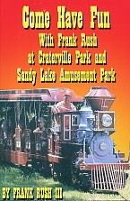 |
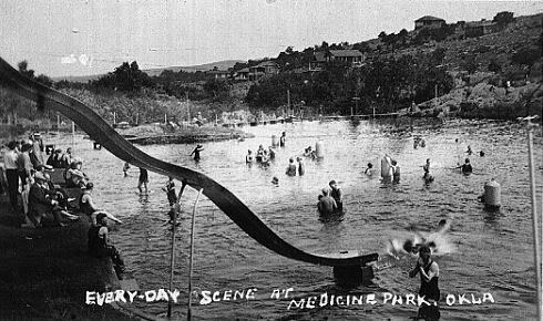
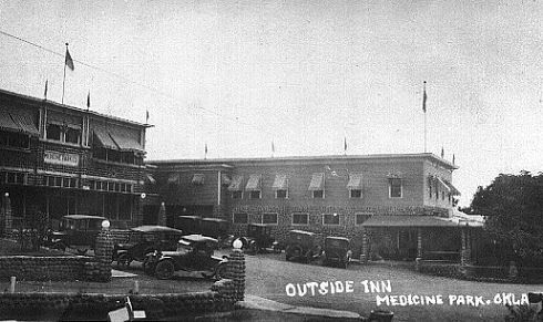
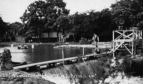
Medicine Park. According to Medicine Park's website, it was founded on July 4, 1908, by Senator Elmer Thomas. It sits along the east edge of the Refuge and was once a very popular tourist area, like in the 1920s-1930s. Many excellent 1920s photo images are provided by the Whitworth Family webpage, three of which are below:
Medicine Park's website says,
Medicine Park became the “playground” for the State’s rich, famous and notorious. Folks would come to town for the week-end and leave their “work-a-day” world, troubles and reputations behind them. Outlaws and horse thieves mixed with noted politicians and businessmen, families and socialites in this new cobblestone community.That popularity lessened substantially and by the time I was growing up in Lawton it was pretty run down, even if picturesque with its cobblestone buildings. I understand that it has been and is being spruced up these days ... its website says, "Medicine Park has grown into an arts community with several artists in residence including sculptors, fine artists, graphic designers, musicians including street theater actors." Next time I visit I'll report back and let you know.
The pages of the Town’s colorful history are filled with the likes of Will Rogers, Wiley Post, Frank Phillips, Bob Wills, Al Capone, Bonnie and Clyde, Pretty Boy Floyd, Lil Hardin, Colonel Jack Abernathy, Les Brown, Roy Rogers and Dale Evans and countless others.
Meers. Just north of the Refuge is a bump in the road called, "Meers." But, it's a regionally famous bump these days because it hosts the old Meers Post Office and Restaurant ... and if you've not enjoyed sinking your teeth into a "Meersburger," you've missed one of life's most succulent pleasures! A couple of Christmas' ago, my daughter & son-in-law kindly presented me with a copy of Greg Burn's neat drawing, below, which I've scanned ... click on the image for a larger image ...

The Holy City. The Holy City, built in part with federal money during the Great Depression by the Works Project Administration, hosted an annual Easter Drama staged by locals. See its organization's website, and the OHS On-Line Encyclopedia of Oklahoma History, for more detail. Although it depicted a religious event, Doug Dawg can assure his readers that, as a teenager, lots of heavy necking was going on under the blankets on the hill overlooking the pageant as one "watched" the Easter sunrise drama unfold! A B-movie was even made surrounding this pageant in 1949. Doug Dawg even "acted" in the Pageant (not the movie) with his DeMolay brothers on one occasion ... can't remember what I did, no "words," nothing significant, probably a soldier or something else filling in the background.
According to The Holy City website,
Located in the Wichita Mountains Wildlife Refuge, this 66-acre area looks much like Israel during Biblical times, and is the site of the nation's longest running Easter passion play, "The Prince of Peace." Attendance reached an all-time high in 1939 when 225,000 visitors jammed Audience Hill for the sunrise performance. Other attractions include a memorial for the victims of the Oklahoma City bombing, a Veterans Walkway, and the World Chapel, which has become a popular wedding locale.From that website, while the show still "goes on," it ends around 10:30 p.m., definitely shortened from the older version which lasted until sunrise on Easter Day! Here are a couple of images from the organization's website ... click the link to see more. I'll take my own pics in the future.


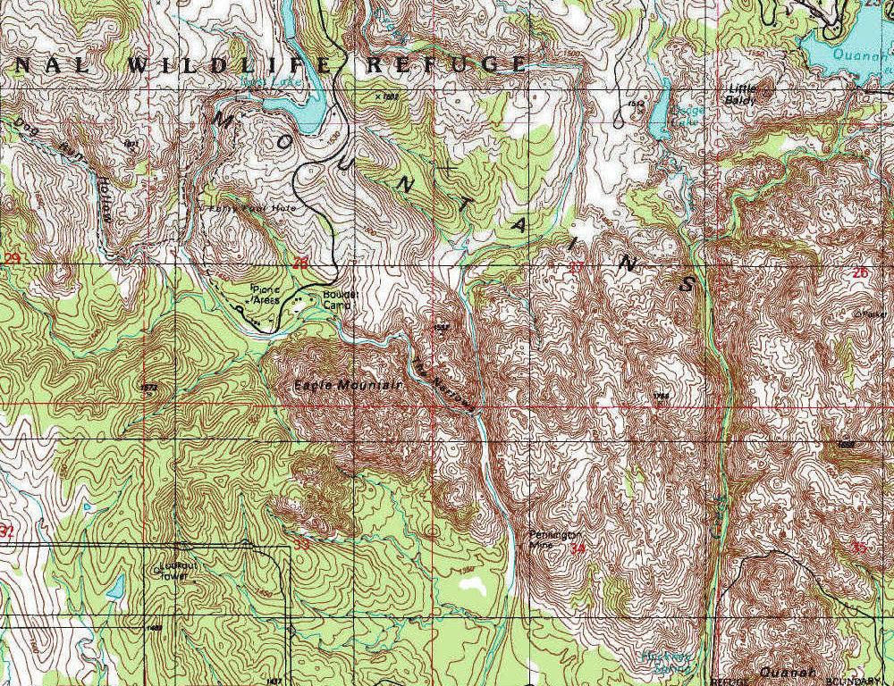
Camp Boulder. This area was my main "hang out" ... from here you could hike "up" the creek to the "40 Foot Hole" ... a small waterfall with a deep hole inside a small but lovely canyon ... or hike "down" the creek (actually, climbing a good part of Eagle Mountain was necessary to get there) along "The Narrows" to arrive at a sumptuous swimming hole surrounded by mountains. Taking this trek is not recommended unless one is in good shape ... it's not an easy walk.
MAPS. A fairly nice "starter" map furnished in a PDF file by the US Fish & Wildlife Service gives a quick, if not particularly detailed, overview of the area.

But, that's really not much of a map! Soooo ... I decided to "make" (actually scan, copy/paste) my own ... move your mouse pointer around the small image below ... info will appear at the top of the image ... and then click on what you want to see. You may need to click the map to activate it.
A large (5200 x 2750 px, 5.44 MB) single file with all of the above is also available. Left-click on the following link below to open, right-click to save, this file: Click Here For The Large Single File.
Three segments of the topographical map which may be most useful are included below. Click on an image for a larger map ...

Camp Boulder & Vicinity
Post Oak & Treasure Lake

PICTURES. Ahhh ... you see that I don't have any uploaded just yet ... but I'm hoping to have some volunteers help fill the void until I take some of my own ...


No comments:
Post a Comment