
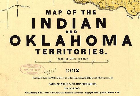
In addition to the 1905 Oklahoma Map by Geographical Publishing Company of Chicago, another very high resolution map located in the Library of Congress map files is the 1892 Oklahoma and Indian Territories map made by Rand, McNally & Company, also of Chicago. This map has no "gazetter" or other index of populations and/or towns, at least, not in its LOC version. However, it does contain some information that the 1905 map does not -- occasional "road" trails, Indian treaty information, and it also presents a clearer demarcation between Oklahoma and Indian Territories.
State Map Oklahoma County Vicinity Tulsa Vicinity
Quadrants: Northwest Southwest Southeast Northeast
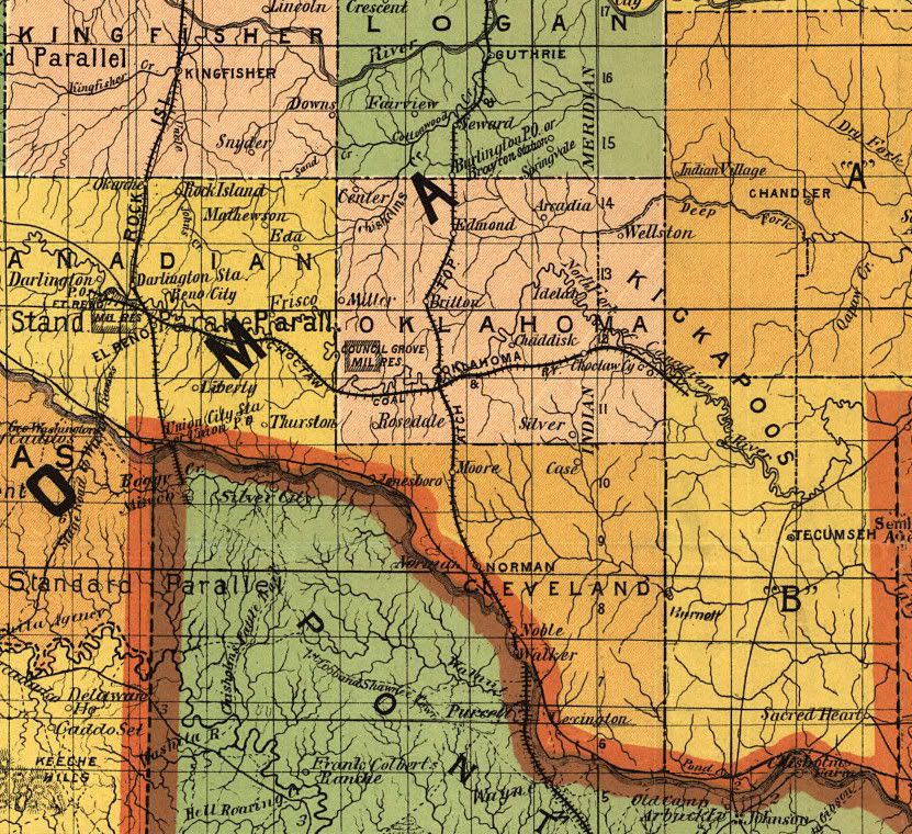
A Preliminary Word of Caution: A spot-check of the Oklahoma County section of the map gives cause to think that Rand McNally did not take as much care with this map as Geographical Publishing Company did with its 1905 map -- at least a pair of towns shown to be in Oklahoma County are not -- Wellston, located in Lincoln County, and Rosedale, located in McClain County -- barring the unlikely event that those towns secretly pulled up stakes and moved from Oklahoma County after the 1892 map was prepared and about which possible exodus I could find no basis in fact.
So, while this map should apparently be viewed with a critical eye, it nonetheless presents an interesting comparison between the territories during the 13 year time-span between 1892 and 1905. As with the 1905 map article, high resolution images are available here for download for them that wants. You can also download the map for yourself at the Library of Congress website. If you do, the LOC file format is a "MrSid" file and you will need to download and install the free MrSid viewer from the LOC website, here, as I did. It's a small and efficient program that allows conversion to a different file format, as I've done with the images presented in this article. The downloaded file is very large -- 9774 x 7200 pixels!
The Full State Map. One of the most useful items in this map is its presentation of railroads and comparing that with the 1905 file. Keeping in mind that this map was prepared only three years after the 1889 Land Run, that change is astonishing and remarkable. If Rand McNally did its job reasonably well, it is also apparent that the number of towns increased dramatically between the production of this map and the 1905 rendition.
Click here for a 3000 x 2210 px view, or
Click here for a 4000 x 2947 px view, or
Click here for a 8624 x 6353 px view
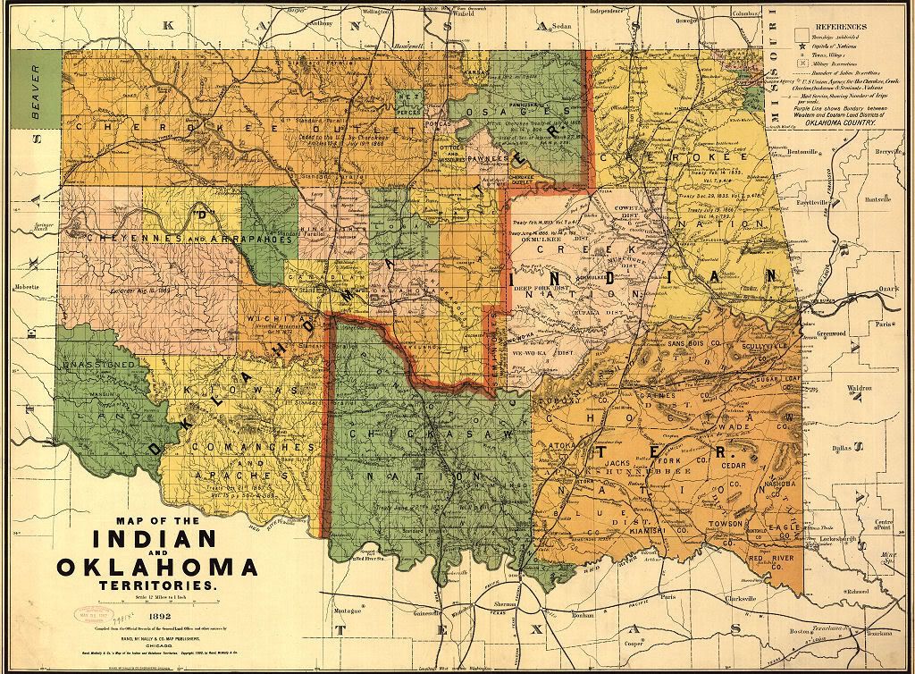
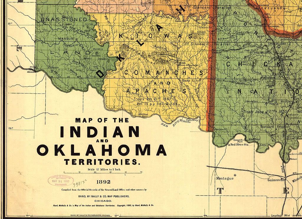
Oklahoma County Vicinity. Below, look closely and see the "Stage Road" running south of El Reno. Remember, in 1892, cars didn't exist. Also note that Chickasha, which would come to be located in Indian Territory directly south of El Reno, apparently did not then exist.
At the time of the 1889 Land Run, Oklahoma (City) had only one railroad passing through it, the north/south Atchison, Topeka & Santa Fe. By 1892, it had one other, a small piece of the Choctaw Coal & Railway Company east/west line, running from slightly west of El Reno to slightly east of Choctaw in what would become Pottawatomie County.
Click here for a 2068 x 1896 px view
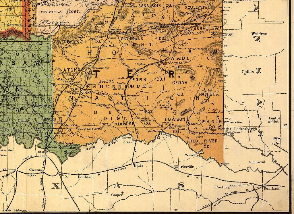
While the Choctaw Coal & Railway Company railroad line terminated east of Choctaw in what would become Pottawatomie County, if you look at the state map or the southeast quadrant, below, another segment of the same railroad is visible running from near the eastern border of Oklahoma through just west of McAlester, shown in small form below:
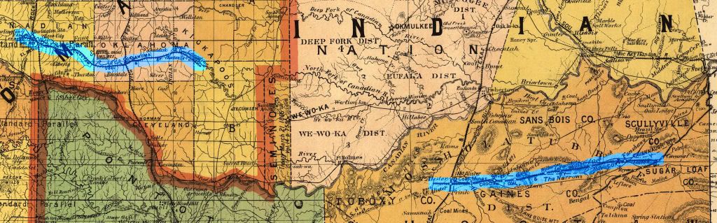
In 1902, this railroad became part of the fondly remembered "Rock Island" line, the Chicago, Rock Island and Pacific, and ran from Little Rock to Amarillo and points west. About this railroad, the OHS's Encyclopedia says this:
In 1885, after a field survey disguised as a turkey hunt, Edward D. Chadrick, a financier from Minneapolis, persuaded another titan of the railroad industry, the Lehigh Valley Railroad, to build a line that would tap the coal fields around Wilburton. The result was the incorporation of the Choctaw Coal and Railway Company in 1887 and the construction of a sixty-seven-mile line between Wister and South McAlester that was completed in 1890. This road permitted development of the coalfields at Wilburton, Alderson, and Hartshorne. Reorganized in 1894 as the Choctaw, Oklahoma, and Gulf Railroad Company, the line remained the territory's largest producer until acquired by the Chicago, Rock Island, and Pacific Railroad in 1902. Its mining subsidiary, the Rock Island Coal and Mining Company, continued to be one of the most powerful entities in Oklahoma's coal industry until the Great Depression.Also, see this website and this one which states,
Choctaw, Oklahoma and Gulf Railroad Company - Incorporated by act of Congress, provided "that the purchasers of the rights of way, railroads, mines, coal lease-holds, estates, and other property, and the franchises of the Choctaw Coal and Railway Company at any sale made under or by virtue of any process or decree of any court having jurisdiction thereof, shall be, and are hereby, constituted a corporation and shall be vested with all the right, title, interest, property, property, possession, claim and demand in law and equity, of, in, and to such rights of way, railroads, mines, coal leasehold estates, and property of the said Choctaw Coal and Railway Company, and with all the rights, powers, immunities, privileges, and franchises which have been heretofore granted to or conferred upon said Company by any Act or Acts of Congress, or which it possesses by virtue of its charter under the laws of Minnesota."Oklahoma County and Then Some. As this is initially written, I've not "spot checked" any part of this map other than Oklahoma County for accuracy. Unfortunately, that spot-check shows at least two towns being located in Oklahoma County which were actually located elsewhere -- Rosedale was and is located in McClain County and Wellston was and is located in Lincoln County. Whether the results of this one-county spot check would be similar in other parts of the map, I can't say since I've made no attempt to do that elsewhere -- but I'd be surprised if similar errors aren't present in other parts of the map. So, as said at the outset of this article, look at this map "critically" and don't assume that what it presents is necessarily exactly accurate. Here's a close look at Oklahoma County in this map:
In 1894, The Choctaw, Oklahoma and Gulf Railroad took over the Choctaw Coal and Railway Company and immediately launched a large scale expansion program. The gap between McAlester and Oklahoma City was closed in October, 1895. The El Reno to Weatherford extension was completed in 1898.
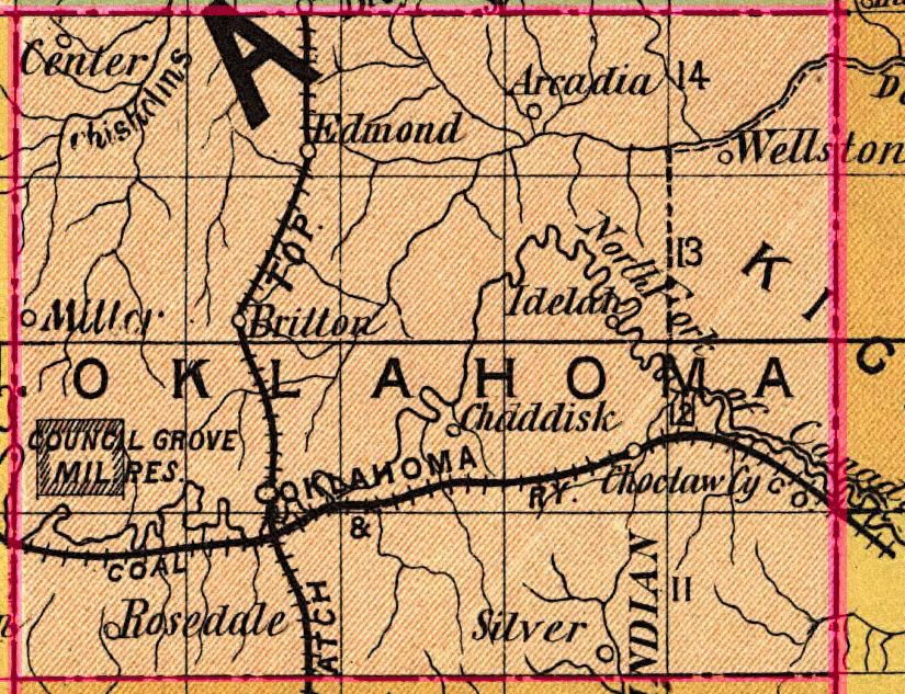
Aside from Wellston and Rosedale, this map shows other towns not located in the 1905 map: Center, Idelah, Chaddisk, Miller, and Silver. I've found nothing about them -- I'm fully expecting that Charles G. Hill will help out with this as he did with the 1905 map concerning Oklahoma County towns!
 As to Council Grove, I've just done an article on that important piece of Oklahoma County history. As is developed in that article, at least a pair of famous names associated with early Oklahoma County and City history are associated with this early day site, Jesse Chisholm and our 1st provisional mayor, William C. Couch.
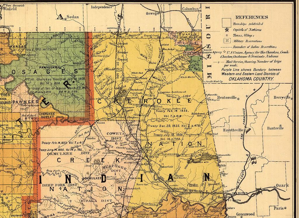
The Tulsa Vicinity. According to this website,
It wasn't until the establishment of the Post Office in March 1879 that the name Tulsa was adopted as the growing city's name.So, presumably, when this 1892 map was made, Tulsa's population would have been between those two numbers. For Tulsa history buffs, see the Tulsa Historical Society website for much more.
In 1882, Tulsa's population was about 200. But, by the time the city was incorporated on January 18, 1898, the population had sprouted to 1,100.
Click here for a 1718 x 1838 px view

Northwest Quadrant. This map was received at the Library of Congress on May 31, 1892, but it doesn't bear an exact date. But, from the drawing, it appears that only two of the six land openings in Oklahoma Territory had occurred: (1) Land Run of 1889 on April 22 (Logan, Kingfisher, Oklahoma, Payne, and Cleveland counties); and (2) Land Run of 1891 on September 22 (Lincoln and Pottawatomie counties). The third, the 1892 Land Run on April 18 (Blaine, Dewey, Day – obsolete county combined with Ellis, Roger Mills, Custer, and Washita), does not appear to have occurred when this map was made.
Click here for a 2400 x 1745 px view, or
Click here for a 4400 x 3200 px view
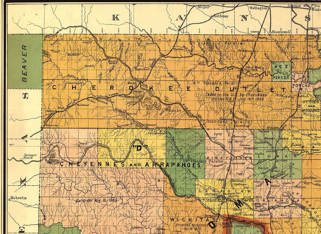
Southwest Quadrant. As is evident from the 1892 map's southwest quadrant, no land openings had occurred which affected this area. Ft. Sill is present, but neither Chickasha nor Lawton yet exist. Aside from the Atchison, Topeka & Santa Fe railroad along the east side, rail lines were not present in the southwest.
Click here for a 2400 x 1745 px view, or
Click here for a 4400 x 3200 px view
Southeast Quadrant. Several rail lines are present and McAlester appears to be the focal point, including a segment of the Choctaw Coal & Railway line discussed in the Oklahoma County vicinity, above.
Click here for a 2400 x 1745 px view, or
Click here for a 4400 x 3200 px view
Northeast Quadrant. Fairly heavily populated with rail lines, concentrations were in Vinita, Claremore, and Wagoner.
Click here for a 2400 x 1745 px view, or
Click here for a 4400 x 3200 px view


3 comments:
Well, let's see. Miller was settled around 1890 and had a population of 9 in the 1900 Census. The post office closed around 1903-04, with Britton assuming responsibility for the mail.
"Chaddisk" is almost certainly Chaddick, which eventually became Dickson. It's also a little out of position, though not so far out as, say, Wellston.
Idelah was settled in the winter of 1889-90; it didn't last long. I did turn up a transcription from a town directory in 1890, starting out with John Concannon, who was the postmaster. The post office was closed after 1891, with mail going to Choctaw.
I know nothing about Silver, other than it did have its own postmark, and that it was discontinued circa 1894.
Center, founded in 1890 and so named because it was believed to be the center of the hitherto Unassigned Lands, was renamed Whisler shortly thereafter. There remains a Whisler (aka "Whistler") Cemetery, on Covell Road (NW 206) east of MacArthur. The Whisler post office was active until 1904.
Chaz, your da man!
You do great work.
Very helpful.
Post a Comment