
SIZE AND LOCATION. Writers sometime state that Delmar Garden occupied 140 acres, but that can't be literally accurate. Probably, they mean what was said in A History of the State of Oklahoma 1908, page 38, where it speaks of Colcord Park Corporation’s ownership of “a tract of one hundred and sixty acres in the city devoted to public amusement and recreation, including the baseball park, the race track, Delmar Garden, etc.” Delmar Garden was one thing and Wheeler Park was another but both were parts of a sometimes magnificent recreational area just west and south of downtown.
 Delmar Garden was west of Western and south of Reno - the 1927 Farmers Market building occupies a small piece of Delmar Garden's space today. Wheeler Park was roughly bounded by Western on the west, Southwest 7th on the north, Lee and on the east, and the North Canadian River on the south. Click this 1907 city atlas for a closer look.
 Compare the above with this 2006 Google map. Notice that the meandering North Canadian has been straightened out considerably and moved south. Click the map for a better look.
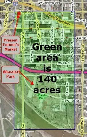
I've looked pretty hard to find actual boundaries of the entire recreational area to no avail. Probably the most reliable is the 1907 city atlas drawing, above. But, the combined space of Delmar Garden and Wheeler Park shown there doesn't come close to being the 140 acres which this article claims it to be, a statement repeated in Central State University's Newcomers to a Newland 4 ½ minute audio piece - it's the one labeled "Sinopolo Brothers-Greek-DelMar Gardens".
If the recreational area did occupy 140 acres, this Google satellite photo shows just how big 140 acres would be. I'm blindly guessing about the boundaries - I'd be amazed if they were not quite different. This is a "size" and not a "boundary" demonstration. The pink item shows the new Crosstown.
HISTORY. From this article at the Oklahoma City Metropolitan Library System (you may have to click your Refresh button once there).
Delmar GardenA more colorful article was written by Jeff Chapman at Cinema Treasures:
By Larry Johnson
Delmar Garden was the premiere playground for Oklahoma City in the first decade of the Twentieth Century. Located on the north side of the North Canadian River at Noble (now SW 3rd) and S Western, Delmar Garden was built by Greek immigrant John Sinopoulo in 1902. Sinopoulo came from St. Louis and fashioned Delmar Garden after a park of the same name there. The recreation spot featured a dance pavilion, outdoor dining, a horse racing track, a beer garden, theatre and amusement rides.
Famous performers include Lon Chaney, Buster Keaton, and boxer John L. Sullivan. While not a true "trolley park" like Belle Isle would be, Delmar Garden had a close relationship with the street car system and thousands of riders visited the park every year. Delmar Garden eventually fell victim to prohibition after statehood in 1907 and the capricious North Canadian River, which flooded the area regularly, and closed in 1910. The Public Market now stands on part of the original Delmar property.
Athel Boiter, a sweetheart of a man who was a film booker knowledgeable in theater lore, once told me the history of Delmar Garden Theater.For more reading, see this very nice thread at OkcTalk.com based upon a fine September 2004 article by The Downtown Guy which is no longer at his website ... or you can read his article here.
Mr. Boiter said that John Sinopoulo was a Greek immigrant who wanted to build a stylish amusement complex that held a uniting theme throughout a park setting. In 1902 Sinopoulo opened on the banks of the North Canadian River his Delmar Gardens Amusement Park, which was designed in elaborate Art Nouveau styling that blended blissfully with surrounding wooded acreage.
Delmar Gardens Park offered an exotic animal zoo, festive penny arcade, thrill rides, cafes and a fine restaurant, a floating wedding chapel, a swank ballroom, a blue ribbon horse racing track, a tranquil boardwalk beer garden, a high class saloon dance hall, and a top notch 3000 seat theater.
Delmar Garden Theater interior was designed in intricate Victorian gingerbread, with Art Nouveau accents. Orchestra seating held leather upholstered opera chairs, box seats contained comfortable wicker chairs and love-seats, and three horseshoe shaped balconies were equipped with steep pitch bleachers. While the auditorium had soft gas lighting, the heavily draped stage was brilliantly illuminated by electric switchboard lighting. Built to be a vaudeville house, Delmar Garden Theater also installed film equipment in 1903 to feature "The Great Train Robbery", which ran for eleven weeks. Regardless of the fact that film showings at the Delmar proved to be successful, management preferred to continue mainly as a two-a-day vaudeville venue, with only an occasional movie thrown in at the end of a weak vaudeville program. (One advantage for vaudvillians appearing on the family oriented Delmar stage was that they could also present "adult material" in late night sketches at the Delmar Saloon).
Lon Chaney, Sr. was appearing at Delmar Theater in 1905 when he rescued a beautiful 16 year-old songbird from a flooded basement dressing room. Her name was Cleva Crieghton, and after a whirlwind courtship the couple married there in Oklahoma City, but whether or not they took advantage of the romantic Delmar Garden floating chapel is lost to time.
Back in those early days, every spring the North Canadian River overflowed its banks causing extensive water damage to Delmar Gardens Park. Flooding was the reason for an early demise of this lovely pleasuredome. It closed in 1910, and was razed the following year.
THE PICS. The images below are typically postcards (drawings) found on the Web. Several are from the Oklahoma County Assessor’s Photo Album website, http://www.oklahomacounty.org/assessor/PhotoDowntown.htm, but those are typically available elsewhere on the, as well. Photographs of Delmar Garden are from the Oklahoma Metropolitan Library’s website at http://webinfo2.mls.lib.ok.us/okimages/okimages.asp?WCI=BeginSearch. Click on an image for a larger view. These images are also located at here at my website.
Before Prohibition, Mosquitoes and Floods Did It In


WHEELER PARK
1st Location of the Oklahoma City Zoo
According to The Downtown Guy's article,
And the zoo that opened at Wheeler Park in 1904 moved to Northeast 50th and Eastern Avenue after most of the animals were killed in a major flood in 1923. The park was literally cut in two when the river, over flood stage, overtook the Lake Overholser dam.


By the way, if you're curious about what the North Canadian looks like these days where it hasn't been tamed by the Army Corps of Engineers, you can still see it in the more pristine Stinchcomb Wildlife Refuge located north of Lake Overholser where the North Canadian is apparently still pretty much the way that it used to be. For some nice pics and a description of that area's history, see http://www.okcoutdoornetwork.org/Stinchcomb.htm. A couple of its images appear below:


Be sure to be prepared to rough it. But it's good to explore, don't you know?


14 comments:
Wow. Excellent post, Doug. Your blog is proving to be a must-read for fans of OKC history and nostalgia. Great job!
ditto what writerranger said! Love it!
jb
Thanks, Jason ... I'm guessing that "jb" would be Jason Bondy whose blog contains the best Oklahoma photos available anywhere!
Doug, Enjoyed your site, especially Wheeler Park Photo Cards! Warranty Deed for Wheeler Park - from James B. Wheeler filed May 13, 1902. Description: Beg. point where west line of said N. bank of North Fork of Canadian River; thence in an easterly direction following meanderings of said North Bank of the No. Fork of the Canadian River to a point South of S/W corner of Wheelers Addition to Okla. City; thence in North & North westerly direction along West line of said Wheeler's Addition (to point where West line of said Wheeler's Addition) intersects South line of right-of-way of St. Louis & San Francisco Railway Company across said Quarter section; thence West along South line right-of-way of said St. Louis & San Francisco Railway Co. to West line of said tract; thence South along West line of said land to the point or place of beginning;
Containing Fourty-three and 9/10
(43 9/10) acres, more or less.
Thanks, Anon ... are there restrictive covenants and/or reversion clauses in the deed?
Doug, Yes! After desc.:"said land to be perpetually used by party of second part as a public park for the free use and benefit of the citizens of Oklahoma City.
The consideration of the deed in the following agreement by said City of Oklahoma City herby made and entered into with the said James B. Wheeler, grantor, to wit:
The second party in consideration of the above grant, deed and conveyance hereby agrees to and with the party of the first part that the tract of land hereby conveyed shall be perpetually known as Wheeler Park, and that the name of said park shall never be changed, and that said City of Oklahoma City herby agrees to spend annually not less than Two Thousand ($2,000) Dollars per year for the period of five years in improving and beautifying the said park;said expenditure and work of improvements to begin within sixty days from this date, the said work of improvement to be performed under the direction of the Mayor and City Cuncil of said City of Oklahoma City.
"It is likewise hereby provided and agreed by and between the grantor and grantee that no Whiskey, beer or other intoxicating liquer shall ever be sold, given away or used on said tract, and that a violation of this provision of this deed shall under said deed void and said tract of land hereby conveyed shall revert to the grantor, his heirs or assigns,to have and to Hold the same, together with all and singular the tenements, hereditaments and appointenances thereunto belonging,or in otherwise appertaining, forever.
And said grantor for himself, his heirs, executors, does hereby covenant,promise and agree to and with said party of the second part, that at the time of the delivery of these presents he is lawfully signed in his own right of an absolute and indefeasible estate of inheritance;in fee simple, of and in all and singular the above granted and described premises, with all the appurtenances, that the same are free, clear, discharged and unincumbered of and from all former and other grants, titles, charges, estatee, judgements, taxes, assessaments and incoumberances of what nature or kind soever, and that he will warrant and forever defend the title to the same unto said party of the second part and its successors against said party of the first part, his heirs and all and every person or persons whomsoever lawfully claiming the said or any part whereof." In witness whereof, the said party of the first part has hereunto set his hand the day and year first above writteh. (date of indenture written May 12 A.D.1902 ...
recorded May 13,1902.
Hmmmm... no beer at a baseball or softball game? [grin]
Doug -
Great blog! What do you know about a "Maple Street" that was in the vicinity of Wheeler Park? My mother's birth certificate lists a "Maple Street" as her address, and I know (or at least believe) from visiting my grandfather as a kid (and being taken to Wheeler Park), that "Maple Street" was somewhere in that vicinity. It may have become SW 11th?
Thanks!!
Hi, Nebraska, and thanks.
Yes, you hit it on the head ... Maple Street was renamed as 11th, more particularly where you're looking, S.W. 11th. Here's a map of the area.
I should have said "South" 11th, S.W. 11th being west of the Santa Fe railroad tracks, generally. The map linked to, above, is a crop from a Sanborn Insurance Map Company map made in 1922.
Nebraskan, if you have an exact street address, I'll get you a more particular map.
I remember well a house at 531 SW 11th, and the family next door, as well as a small grocery store on the west, and a greenhouse, or place that made flower pots, a block on further west. But that's on my father's side. My mother's birth certificate simply says "Maple Street," but I know it was in the neighborhood.
Thanks for the help!!
I found this and wondered if you had seen it. It doesn't really break any new ground and seems worded similiarly to a lot of you book even. http://video.google.com/videoplay?docid=-4155617387994756588&q=centennial+stories
Thanks, WaDeLiCiouS,
Yes, I've seen the video. Actually, Billie Rodley (sp?) put it together for OETA and she used stuff from the Springlake blog article liberally, which was OK by me. The OETA videos are linked on a blog page here: OETA videos but I don't know if the links are good any more.
Post a Comment